
Östliches Ringgebiet
Östliches Ringgebiet | |
|---|---|
.JPG) Aerial view of Östliches Ringgebiet | |
Boroughs of Braunschweig  | |
 Östliches Ringgebiet  Östliches Ringgebiet | |
| Coordinates: 52°16′9″N 10°32′33″E / 52.26917°N 10.54250°E | |
| Country | Germany |
| State | Lower Saxony |
| District | Braunschweig urban district |
| City | Braunschweig |
| Government | |
| • Mayor | Juliane Krause (Greens) |
| Area | |
| • Total | 3,976 km2 (1,535 sq mi) |
| Population (2020-12-31)[1] | |
| • Total | 26,559 |
| • Density | 6.7/km2 (17/sq mi) |
| Time zone | UTC+01:00 (CET) |
| • Summer (DST) | UTC+02:00 (CEST) |
| Postal codes | 38102-38104-38106 |
| Dialling codes | 0531 |
| Vehicle registration | BS |
| Website | Official Website |
The Östliches Ringgebiet is a Stadtbezirk (borough) in the eastern part of Braunschweig, Germany. With a population of 26,559 (2020) it is the city's second most populous district.
History
.jpg)
Originally located outside of the city, the Östliche Ringgebiet (Eastern Ring Area) was developed as a residential area during the Gründerzeit in the late 19th century, when industrialisation caused a rapid growth of population in the city.[2]
The centre of the district is the
Politics
The district mayor Juliane Krause is a member of the Green party of Germany.[5]
Main sights
- The townhouses on Jasperallee.
- The neo-gothic church St. Paul's (German: St. Pauli) and the neo-romanesque church St. Matthew's (German: Matthäuskirche).
- The historical water tower Wasserturm auf dem Giersberg, built in 1901.
- The Mars-la-Tour barracks, former garrison of Brunswick's hussars.
-
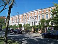 Townhouses on Jasperallee
 -
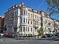 Townhouses on Jasperallee
 -
 St. Paul's Church
 -
 St. Matthew's Church
 -
 Wasserturm auf dem Giersberg
 -
 Mars-la-Tour barracks


Sports and recreation

Two parks are located on the eastern end of the Östliche Ringgebiet, the Stadtpark and the Prinz-Albrecht-Park (short: Prinzenpark). The latter is named after Prince Albert of Prussia (German: Albrecht von Preußen), regent of the Duchy of Brunswick from 1885 to 1906.
From 1947 until 1951 the annual motorsport competition Prinzenpark-Rennen was held at a race track within the Prinz-Albrecht-Park.[6][7] Prinzenparkstadion, the stadium of association football club FT Braunschweig, is also located within the park.
References
- ^ "Einwohnerzahlen nach Stadtbezirken". Stadt Braunschweig. Retrieved 21 September 2021.
- ^ Östliches Ringgebiet: Geschichte (in German). Retrieved on October 3, 2012.
- ^ Zur Geschichte der Straße (in German). Retrieved on October 3, 2012.
- ^ Kaiser-Wilhelm-Straße, heute Jasperallee (in German). Retrieved on October 3, 2012.
- ^ Stadtbezirksrat 120 Östliches Ringgebiet (in German). Retrieved on October 3, 2012.
- ^ Brettspiel erinnert an Prinzenpark-Rennen (in German). Retrieved on April 22, 2013.
- ^ "Rennen! Races! Vitesse!" (PDF).. Retrieved on April 22, 2014.
|  | |