Addu Atoll
Native name: އައްޑޫ | |
|---|---|
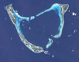
 Addu Atoll seen from space. Note the continuous reef fringing Addu from the west and southwest. | |
| Geography | |
| Location | Indian Ocean |
| Coordinates | 0°39′S 73°10′E / 0.65°S 73.16°E |
| Total islands | 29 |
| Area | 130 km2 (50 sq mi)(lagoon) 15 km2 (5.8 sq mi) (land area) |
| Administration | |
| Demographics | |
| Population | 33,694 (2013) |
Addu Atoll, also known as Seenu Atoll, is the southernmost
Geography
Unlike other atolls of the Maldives, Addu Atoll has a lagoon that is a natural anchorage, accessible through four natural channels. This results in a natural harbour that is very calm and safe for sea vessels at all times and is not affected by seasonal changes. The four channels are arranged around the atoll as follows: the Kuda channel and the nearby Maa channel are on the north, the Gan channel is on the south, and the broad Villingili channel is on the southeast.
The islands are protected from the storms and high waves of the Indian Ocean by barrier reefs. Coconut palms, the national tree, are able to grow almost everywhere on the islands of Addu Atoll. There are small lakes, wetlands, and marshy taro fields that are unique to Addu Atoll.
History
During the
Biology
The cosmopolitan
Inhabited islands
- See Meedhoo
- See Hulhudhoo
- See Hithadhoo
- See Maradhoo
- See Maradhoo-Feydhoo
- See Feydhoo
Uninhabited islands

- Aboohera
- Bodu Hajara
- Boduheragandu
- Dhigihera
- Fahikedeherangada
- Gan (Location of Gan International Airport)
- Gaukendi
- Geskalhuhera
- Hankede Hajara
- Here-there (Location of Canareef Island Resort)
- Hikahera
- Kafathalhaa Hera
- Kandu Huraa
- Kedevaahera
- Koahera
- Kuda Kandihereganda
- Maahera
- Maamendhoo
- Madihera
- Mulikede
- Savaaheli
- Vashahera
- Villingili (Location of Shangri-La Resort)
Linguistics
The spoken dialect is Addu dialect, and though it has similarities to the "Mulaku dialect" of
Culture
Long ago Addu City was ruled by families appointed by the sultans in Malé, and may have had a matrilineal system of inheritance; it is very much a man's world today. There was a recent period in Addu history when the status quo changed for a while, when a more matriarchal society developed and women became the breadwinners.
Addu Atoll has some of the earliest known settlements recorded in the country—specifically, on the island of
References
- HMSO(ISBN none) p25
- ^ Britain's Secret Base; Mike Beninghof, Sept 2018, at avalanchepress.com: Retrieved 12 November 2019
- ^ Staff, M. D. (3 February 2018). "Maldives' Wetlands Help Fight Climate Change". Modern Diplomacy. Retrieved 23 February 2019.
Bibliography
- Frampton, Victor; Grobmeier, A. H.; Johnson, Harold & Pitt, G. L. B. (2003). "British Naval Base at Addu Atoll". Warship International. XL (2): 126–128. ISSN 0043-0374.
External links
 Media related to Addu Atoll at Wikimedia Commons
- https://www.youtube.com/playlist?list=PLYTjyn6fVp5jSqXeDQCmWfNDQGAZ3lK3D The Atoll recreated in Cities: Skylines by a Youtuber. name, Strictoaster


