
Afghanistan–China border

The Afghanistan–China border is a 92-kilometre-long (57 mi)
Both sides of the border are
The border marks the greatest terrestrial time zone difference on Earth, with a 3.5 hour difference between Afghanistan's UTC+4:30 and China's UTC+08:00.[2]
History
The border was established between Afghanistan and China in an agreement between the British and the Russians in 1895 as part of
It is believed that in more recent times, the main pass, Wakhjir Pass, is sometimes used as a low intensity drug smuggling route, and is used to transport opium made in Afghanistan to China.[7] In the 2000s, Afghanistan has asked China on several occasions to open the border in the Wakhan Corridor for economic reasons or as an alternative supply route for fighting the Taliban insurgency. However, China has resisted, largely due to unrest in its far western province of Xinjiang, which borders the corridor.[8][9] In December 2009[update], it was reported that the United States had asked China to open the corridor.[10]
There have been proposals and plans by Kashgar regional government to open Tegermansu Pass as a port of entry for economic purposes since the 1990s.[11][12] However, this has yet to happen.
Geography

Article 1 of the 1963 treaty describes the Afghanistan–China border, starting from the southern end:
starting from a peak with a height of 5,630 meters--the reference coordinates of which are approximately 37 degrees 03 minutes north, 74 degrees 36 minutes east in the southern extremity, the boundary line between the two countries runs along the Mustagh Range watershed between the Karachukur Su River, a tributary of the
Aksu River and the Wakhjir River, the upper reaches of the Wakhan River, on the other hand, passing through South Wakhjir Daban (Called Wakhjir Pass on the Afghan map) at the elevation of 4,923 meters, North Wakhjir Daban (named on the Chinese map only), West Koktorok Daban (named on the Chinese map only), East Koktorok Daban (called Kara Jilga Pass on the Afghan Map), Tok Man Su Daban (called Mihman Yoli Pass on the Afghan map), Sirik Tash Daban (named on the Chinese map only), Kokrash Kol Daban (called Tigarman Su Passon the Afghan map) and reaches Peak Kokrash Kol (called Peak Povalo Shveikovski on the Afghan map) with a height of 5,698 meters.
The border's northern terminus is found at the
Border crossings
Historically, the main crossing between the two sides was Wakhjir Pass. Wakhjir Pass has been in use for at least a millennium since the Silk Road. In addition to Wakhjir Pass, there is also Tegermansu Pass which is located on the far eastern end from Little Pamir.
The passes are closed as
Historical maps and gallery
Historical English-language maps of the Afghanistan–China border, mid to late 20th century:
-
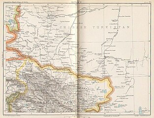 Map of the region (1893)
 -
 Map including the Afghanistan–China border (1917)
 -
![From the International Map of the World (AMS, 1966)[b]](//upload.wikimedia.org/wikipedia/commons/thumb/a/ae/Txu-oclc-6654394-nj-43-5th-ed.jpg/215px-Txu-oclc-6654394-nj-43-5th-ed.jpg)
-
 Map including Afghanistan–China border (ACIC, 1969)
 -
![Border region (DMA, 1980)[c]](//upload.wikimedia.org/wikipedia/commons/thumb/f/fb/Operational_Navigation_Chart_G-7%2C_6th_edition.jpg/331px-Operational_Navigation_Chart_G-7%2C_6th_edition.jpg) Border region (DMA, 1980)[c]
Border region (DMA, 1980)[c] -
![Border region (DMA, 1984)[d]](//upload.wikimedia.org/wikipedia/commons/thumb/a/a1/Txu-pclmaps-oclc-22834566_g-7a.jpg/335px-Txu-pclmaps-oclc-22834566_g-7a.jpg) Border region (DMA, 1984)[d]
Border region (DMA, 1984)[d] -
 Satellite image of the region with the Afghanistan–China border marked
 -
 Wakhan Corridor including Afghanistan–China border

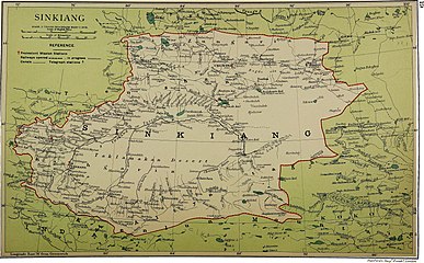
_p61_PLATE19._SINKIANG_(14597194848).jpg)
![From the International Map of the World (AMS, 1966)[b]](/File:Txu-oclc-6654394-nj-43-5th-ed.jpg)

![Border region (DMA, 1980)[c]](/File:Operational_Navigation_Chart_G-7,_6th_edition.jpg)
![Border region (DMA, 1984)[d]](/File:Txu-pclmaps-oclc-22834566_g-7a.jpg)

_Corridor.jpg)
See also
Notes
- ^ From map: "NAMES AND BOUNDARY REPRESENTATION ARE NOT NECESSARILY AUTHORITATIVE"
- ^ From map: "DELINEATION OF INTERNATIONAL BOUNDARIES MUST NOT BE CONSIDERED AUTHORITATIVE"
- ^ From map: "The representation of international boundaries is not necessarily authoritative."
- ^ From map: "The representation of international boundaries is not necessarily authoritative"
References
- ^ CIA.
The new boundary, 57 miles long,{...}and reaches Peak Kokrash Kol (called Peak Povalo Shveikovski on the Afghan map) with a height of 5,698 meters.
- CIA.
- ^ Stein, M. Aurel (1903-06-30). "Exploration in Chinese Turkestan". United States Congressional Serial Set. No. 748. Washington, D.C.: Smithsonian Institution. p. 752. Retrieved 2017-02-03.
- ^ a b [Afghanistan-China Border Agreement] (in Chinese). 1963-11-22 – via Wikisource.
- ^ Office of the Geographer (1969-05-01). "International Boundary Study - Afghanistan – China Boundary" (PDF). Bureau of Intelligence and Research. Archived from the original (PDF) on 2015-01-03. Retrieved 2017-02-03.
The Afghanistan–China boundary agreement, signed on November 22, 1963, was the fifth of these boundaries treaties initiated by the Chinese communists.
- ^ 全国人民代表大会常务委员会关于签订中华人民共和国和阿富汗王国边界条约的决议 (in Simplified Chinese). National People's Congress. Archived from the original on 17 October 2013. Retrieved 12 January 2020.
- ^ "Afghanistan border crossings". Caravanistan. Retrieved 2017-02-03.
It is mostly used as a low-intensity drug-smuggling corridor to bring opium to China during the summer.
- ^ Afghanistan tells China to open Wakhan corridor route. The Hindu. June 11, 2009 Archived January 8, 2011, at the Wayback Machine
- ^ China mulls Afghan border request. BBC News Online. June 12, 2009
- ^ South Asia Analysis Group: Paper No. 3579, 31 December 2009 Archived June 13, 2010, at the Wayback Machine
- ^ "新疆对外开放口岸一览表". china.com.cn (in Chinese). Retrieved 23 December 2019.
国别:阿富汗 口岸名称:托克满苏 开放时间:未定 说明:规划开放口岸(98年) Country: Afghanistan, Name of port: Tegermansu, Opening date: Undecided, Notes: Planning to open the port (1998)
- ^ 喀什地区发展和改革委员会 (Kashgar Region Development and Reform Committee) (2016-03-17). "喀什地区国民经济和社会发展第十三个五年" [Kashgar Regional Economic and Social Development 13th Five-Year Plan (2016-2020)]. Archived from the original on 2019-10-22. Retrieved 23 December 2019.
推进新建中国-阿富汗托克满苏陆路口岸、中国-巴基斯坦铁路口岸、中国-塔吉克斯坦铁路口岸。改善现有口岸通关条件。
- Afghan borderat the Povalo-Shveikovskogo peak (5,543 meters above sea level).
- Washington, D. C.: Army Map Service. March 1967 – via Perry–Castañeda Library Map Collection.
Pik Povalo-Shveikovskogo
- ^ 中华人民共和国和阿富汗王国边界条约 (in Chinese). 22 November 1963 – via Wikisource.
到高程为5698米的克克拉去考勒峰(阿方图称波万洛什维科夫斯基峰)。
- State Ethnic Affairs Commission. 6 July 2004. Archived from the originalon 4 December 2008.
中阿边界{...}南起中、巴、阿3国交界处的5587山峰,沿穆斯塔格山脉分水岭北行至克克拉去考勒峰。
- ^ "China Report Political, Sociological and Military Affairs No. 363" (PDF). United States Joint Publications Research Service. 18 November 1982. p. 1. Archived (PDF) from the original on January 11, 2020. Retrieved 11 January 2020 – via Defense Technical Information Center.
If we open up the Atlas of the People's Republic of China we will find that the region of the Pamir, the western extremity of Xinjiang, from the Wuzibieli [Uzbel] Pass1 to the south down to the Kekelaqukaole Peak (which the Soviet Russians call "Pavel Shveikovsky Peak") is designated as a not limited area.