
Airglades Airport
This article needs additional citations for verification. (January 2013) |
Airglades Airport Riddle Field | |||||||||||
|---|---|---|---|---|---|---|---|---|---|---|---|
AMSL 20 ft / 6 m | | ||||||||||
| Coordinates | 26°44′06″N 81°03′04″W / 26.73500°N 81.05111°W | ||||||||||
| Map | |||||||||||
 2IS Location of Airglades Airport  2IS 2IS (the United States) | |||||||||||
| Runways | |||||||||||
| |||||||||||
| Statistics (2002) | |||||||||||
| |||||||||||
Airglades Airport (FAA LID: 2IS) is a county-owned public-use airport in Hendry County, Florida, United States. It is located 5 miles (8.0 km) west of the central business district of Clewiston, Florida.[1]
Overview
The airport has a lighted 5950-foot runway (13-31) and ample aircraft tie-down space, Avfuel® aviation and jet fuel, and repair facilities for visiting aircraft and locally based aircraft owners. Unicom is on 123.05. Rental are available, as well as a local taxi service for easy travel around the area.
History
In 1941, British Prime Minister
The airfield was opened on 12 November 1942 by the
Daily life at Riddle Field consisted of Primary flight training in the
Local volunteers established a Cadet Club in what was known as the Pioneer Building (on Ponce deLeon Street behind present day U.S. Sugar Corp.) where dances and games were provided. The Clewiston Inn also served as a meeting place for officers and cadets to socialize.
Inactivated 31 December 1945 with the drawdown of AAFTC's pilot training program and was declared surplus in 1946. Responsibility for it was given to the War Assets Administration (WAA) and the facility was eventually acquired by Hendry County.
The present-day Airglades Airport was built after the war over the runways of Riddle Field. The buildings of the wartime field have been replaced by modern buildings, however the airfield is partially still in use. The No. 5 BFTS Association of former students continue their contact with the Clewiston community through periodic visits.
-
 Flying cadet at airfield sign
 -
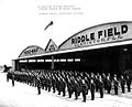 RAF Cadets on Parade
 -
 Cadet training in PT-17 Stearman
 -
 Cadets with AT-6 Texans


See also
- Florida World War II Army Airfields
- List of airports in Florida
- 28th Flying Training Wing (World War II)
References
![]() This article incorporates public domain material from the Air Force Historical Research Agency
This article incorporates public domain material from the Air Force Historical Research Agency
- Manning, Thomas A. (2005), History of Air Education and Training Command, 1942–2002. Office of History and Research, Headquarters, AETC, Randolph AFB, Texas
- Shaw, Frederick J. (2004), Locating Air Force Base Sites, History’s Legacy, Air Force History and Museums Program, United States Air Force, Washington DC. OCLC 57007862, 1050653629
- ^ PDF, effective 2008-9-25
External links
- FAA Terminal Procedures for 2IS, effective April 18, 2024
- Resources for this airport:
- FAA airport information for 2IS
- AirNav airport information for 2IS
- FlightAware airport information and live flight tracker
- SkyVector aeronautical chart for 2IS