
Aller (Germany)
| Aller | |
|---|---|
Seehausen in the Magdeburg Börde | |
| • coordinates | 52°06′09″N 11°14′01″E / 52.1024528°N 11.2337028°E |
| • elevation | 130 m above sea level (NN) |
| Mouth | |
• location | Weser near Verden |
• coordinates | 52°56′45″N 9°11′08″E / 52.945825°N 9.1856139°E |
• elevation | 10 m above sea level (NN) |
| Length | 214.8 km (133.5 mi) [1] |
| Basin size | 15,721 km2 (6,070 sq mi) [1] |
| Discharge | |
| • average | 118 m3/s (4,200 cu ft/s)[2] |
| Basin features | |
| Progression | Alpe, Wölpe |
| • right | Kleine Aller, Ise, Lachte, Örtze, Meiße, Böhme, Lehrde, Gohbach |
| Navigable | 117 km (73 mi); from Celle Class II, from Verden Class III |
The Aller (pronounced [ˈalɐ] ) is a 215-kilometre-long (134 mi) river in the states of Saxony-Anhalt and Lower Saxony in Germany. It is a right-hand, and hence eastern, tributary of the Weser and is also its largest tributary. Its last 117 kilometres (73 mi) form the Lower Aller federal waterway (Bundeswasserstraße). The Aller was extensively straightened, widened and, in places, dyked, during the 1960s to provide flood control of the river. In a 20-kilometre-long (12 mi) section near Gifhorn, the river meanders in its natural river bed.
History
Meaning of the name
The river's name, which was recorded in 781 as Alera, in 803 as Elera, in 1096 as Alara, has two possible derivations:
- A shortened form of *Eleraha, where *Eler in Old German *olisa or Old Slavic olsa (Polish: olsza) would mean Erle ("alder") and aha (pronounced in German: Acha) is an old word frequently used in river names to mean "water" (c.f. the Latin aqua). The name of the tree passed into Low German as Eller, which is very close to the word Aller. Aller would therefore mean something like Erlenwasser i.e. "alder water", which was probably due to the river banks being largely covered in aldertrees that prefer wet locations.
- In Vasconic substratum theory.
Course
Upper Aller

The Aller rises in the state of Saxony-Anhalt in the west of the region known as the
Initially, the Aller flows rather like a canalised brook in a northwestern direction through low hills and intensively farmed arable fields. As it does, it passes the
Near Wolfsburg-Wendschott, the Aller passes under the Mittelland Canal in a culvert where there is a barrier that is impassable to fish. The Aller swings northwest again from Wolfsburg. In the area of the town it crosses the Allerpark and flows past the Allersee before flowing past the Barnbruch.
-
 The Aller near Wefensleben, about 10 kilometres (6 mi) below its source
 -
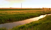 The Aller near Oebisfelde
 -
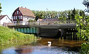 Bridge on the Upper Aller in Wolfsburg-Vorsfelde


South of Weyhausen, the Aller Canal branches off the Aller. The canal was built between 1860 and 1863 and is about 18 kilometres (11 mi) long. It was supposed to drain the long-standing floods that were greatly feared at that time. The canal runs parallel to, and generally a few miles south of, the Aller, rejoining it near Brenneckenbrück (west of Gifhorn). The canal runs south past Gifhorn, whilst the Aller flows through the town. This 20-kilometre (12 mi) long section, which parallels the Aller Canal, is the only section of the Aller that meanders in its natural river channel. Elsewhere, the Aller has been straightened and widened along its entire length from source to mouth. East of Gifhorn near Osloß it crosses under the Elbe Lateral Canal, which is carried over it on an aqueduct. After that it runs via Gifhorn to Müden, where it merges with the Oker.

Middle Aller
The 30-kilometre (19 mi) long section of the Aller from the mouth of the Oker to Celle is referred to as the Middle Aller (Mittelaller). After passing Wienhausen, it is navigable as far as Celle. Here, the river has so much water that there are barrages and the water power is extracted from the river using weirs.
-
 Confluence with the Oker (right) near Müden
 -
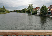 The river in Celle
 -
 Mouth of theWinsen (Aller)

_IMG_2472.jpg)

Lower Aller
The section of the river known as the Lower Aller (Unteraller) begins at Celle and runs for 120 kilometres (75 mi) to the

Aller glacial valley


After the Aller has passed through the hills of Saxony-Anhalt it enters the Wolfsburg area into the
Near Wolfsburg the level of the river bed scarcely dropped at all and during times of low water it became almost an area of standing water. The Wolfsburg Volkswagen Factory uses the river and also feeds waste water, after cleaning, into its own
Today, the landscape of the Aller valley between Celle and Verden is mainly utilised as grassland. The Aller depression there comprises valley floors lying close to the watertable, so that fertile wet areas may be found here with rich habitats for flora and fauna. The landscape is characterised by oxbows, potholes, copses and rows of bushes. The valley floors are widened by the depressions of the tributaries flowing into the Aller, so that fens and bogs can form. Around the lower reaches crops are cultivated on the clay soils. Around the upper course of the river, many pine forests are managed on the sandy soils.
Tributaries
Rivers
The most important
From the right, the Aller is joined by smaller rivers that predominantly drain the
.Streams of the Upper Aller
The Upper Aller has numerous tributary streams between its source and Müden:
|
|
|
Streams of the Aller Canal
The Aller Canal runs parallel to the Upper Aller between Wolfsburg and Gifhorn. The canal was built in the mid-19th century to reduce flooding. It has the following tributary streams:
|
|
Streams of the Lower Aller
From the left, the following small rivers and brooks feed the Aller: the Alpe and the Wölpe near Rethem, the Lehrde near Kirchlinteln-Hohenaverbergen, the Gohbach near Verden-Eitze and, just before its mouth, the Halse near Verden-Dauelsen.
Castles and monasteries
- Bartensleben Castle, built as a water castle
- Oebisfelde Castle, built as a lowland castle (Niederungsburg) probably in the 10th century on a sand bank in the Aller in a swamp area of the Drömling
- Wolfsburg Castle, built as a tower house in the 14th century on the Aller and expanded into a water castle with fortifications
- Gifhorn Castle, completed in 1581 with fortifications
- Cistercianmonastery from the 13th century
- Celle Castle, built in the 10th century as a fortified tower by a ford over the Aller
- Uhlenburg near Essel, built as a manor house in the 14th century
- Blankenburg Castle near Essel
- Ahlden House, built in 1549 as a water castle on the Aller; where the river bed became part of the Leine from 1618 when the Aller changed its course
- Ahlden (Aller)in the 13th century
- Hudemühlen Castle in the Hodenhagen sector of Hudemühlen, built in the 14th century as a castle, converted in the 16th century into a Renaissance schloss and demolished in the 19th century
- Bierde
- Hodenhagen Castle near Hodenhagen
- Blankenhagen Castle near Grethem
- Rethem Castle in Rethem (Aller), built in the 13th century and expanded into a bastioned site in the 17th century
- Verden Cathedral, built in the 12th century
Culture and tourism
The Aller is one of the few – at least to all appearances – undisturbed larger rivers in Germany. From Celle as far as the Verden area it forms, together with the Leine, the attractive landscape of the Aller-Leine Valley. The Aller flows gently through relatively natural surroundings alongside meadows and woods, small villages and country towns. As a result, it is of great importance for those seeking relaxation in Lower Saxony with almost 4 million people in the conurbation of the Hanover-Brunswick-Göttingen-Wolfsburg Metropolitan Region. The Aller Cycle Way, which is around 250 kilometres (160 mi) long and generally follows the course of the river at some distance, is just one of the leisure attractions in the area. There are attempts to make tourism along the river more compatible with nature through the 'soft tourism' (Sanfte Tourismus) initiative, especially in the Aller-Leine Valley. Leisure options include canoeing or travelling by houseboat. Water skiing is allowed on short sections of the lower river.
Hydrology
The river is the biggest tributary of the Weser. The catchment area of the Aller covers 15,744 square kilometres (6,079 sq mi), about one third that of the Weser itself. The water flow gauge at Rethem below the Aller's confluence with the Leine registers an average volumetric flow of 114 cubic metres (4,000 cu ft) per second.
The Aller receives via the
Very little of the Aller is shaded by woods (apart from the section along the Aller Canal). Direct sunlight on much of the river encourages the growth of aquatic plants and, in the absence of shady trees along its banks, the water becomes quite warm during the summer months.
Water velocity
The water velocity of the Aller is very slow in places. In its upper reaches, at the height of the Drömling, the water compares to a sluggish canal and, in some sections, it is almost like a stretch of still water. Its sluggishness is due to the very gradual slope of the channel, which in Lower Saxony averages a mere 10–20 centimetres per kilometre (0.53–1.06 ft/mi). Even in the upper course of the river, the flow across the whole of the stream bed is uniformly slow, due to the river having been widened and straightened. Here, the bed is covered by a mixture of sand and mud.
Sewage
Heavy metal pollution
The pollution of the Aller by
In 1999, investigations were carried out into the heavy metal content of the suspended material in the Aller near Verden. They showed that the Aller was polluting the Weser disproportionally with lead, cadmium, zinc and mercury.[3]
Water quality
The Lower Saxon water quality report
Flooding and historical flood protection


In former times, there were frequently spring floods in the Aller depression that stayed for a long time. This was mainly due to the very gentle slope of the river from its entry into the ice age glacial drainage channel of the Breslau-Magdeburg-Bremen
Current flood protection
In the years 1954–1962, there was increased flooding along the Aller, which caused considerable damage to its water meadows. The flooded areas in the Aller valley varied between 300 and 5,000 metres (980 and 16,400 ft) wide, mainly due to the uneven flow of the river. In 1961, the
Flood protection in Celle region

As early as the 1980s the town of Celle had drawn up a "Plan for Flood Protection of the Celle Region".[6] This described a combination of widely varying measures, such as excavation of the river shore, flood basins and dykes. On 6 June 2005 the town received authority to start the first stage of the flood protection project. In 2006 work was begun.[7] This first part of the work entailed excavation of the river shore between Boye and the confluence with the river Fuhse, which were intended to increase the cross-section of the Aller channel during high water periods.[8] The flood basins have an area of about 15 hectares (37 acres) and are 1.5 metres (4.9 ft) deep, requiring about 240,000 cubic metres (8,500,000 cu ft) of earth to be washed away. The cost of the project came to around 2 million euros. Only two years later, it was determined that these first interventions of the river system had resulted in sand being permanently deposited in the Aller producing shoals. In May 2009, the shipping channel was dredged for the first time in the vicinity of the new flood basins so that ships could once again pass through. Now, it is planned to redesign the basins and, in some cases to fill them in, in order to reduce the future dumping of sand.
Negotiability for fish
In straightening the Aller in the 1960s the slope increased as the shortest route was taken. Ledges (Sohlabstürze) were built on the river bed to reduce erosion; these have since been converted to rock ramps (Sohlgleiten) in order to enable water organisms to pass more easily. There is no longer a barrier to fish at the weir near Grafhorst—designed to raise the water level during summer droughts—since it has been given a fish ladder. The migration of fish is however prevented by weirs near Gifhorn and Müden (Aller) and the locks of the Mittelland Canal near Wolfsburg-Wendschott. The Elbe Lateral Canal near Osloß flows freely under the Aller, however.
Shipping
History
Today
Today, the Aller is a federal waterway from its mouth on the Weser to Celle. This section has a length of 117 kilometres (73 mi) and is known as the Lower Aller. The Verden Water and Shipping Office (Wasser- und Schifffahrtsamt Verden) is responsible for upgrades and new projects. With this authority, responsibility is further subdivided. The Oldau branch is responsible for the Aller from Celle to Hülsen 94.1 kilometres (58.5 mi) further downstream. In contrast, the Verden branch covers the river from Hülsen to its confluence with the Weser near Verden-Eissel 117.1 kilometres (72.8 mi) downstream from Celle.
Since the mid-1960s, only pleasure cruisers and sports boats have been used on the river above Verden towards its source.
Permitted ship sizes
- Mouth–Verden: waterway class III (length × width: 67 m × 9.50 m or 219.8 ft × 31.2 ft)
- Verden–Celle: waterway class II (length × width: 58 m × 9.50 m or 190.3 ft × 31.2 ft)
- Above Celle: not navigable
Locks
_Schleuse_Oldau_2008_by-RaBoe_05.jpg)

In 1907, the
| Place | Location | Usable length | Usable width | Fall | Built |
|---|---|---|---|---|---|
| Oldau | 14.7 km (9.1 mi) |
159 m (522 ft) |
10 m (33 ft) |
3.21 m (10.5 ft) |
1908–10 |
| Bannetze | 26.7 km (16.6 mi) |
159 m (522 ft) |
10 m (33 ft) |
2.40 m (7 ft 10 in) |
1909–12 |
| Marklendorf | 38.3 km (23.8 mi) |
159 m (522 ft) |
10 m (33 ft) |
3.22 m (10.6 ft) |
1914 |
| Hademstorf | 49.8 km (30.9 mi) |
159 m (522 ft) |
10 m (33 ft) |
1.23 m (4 ft 0 in) |
1914–18 |
Timber rafting
Timber rafting was probably being used on the Aller by the 14th century. The logs thus transported were used for construction as well as fuel. An early centre of timber rafting and the wood trade was the princely Residenz town of Celle. At first the nobility had the wood transported as fuel to heat Celle Castle and other royal buildings. The timber was felled in the royal forests. The transportation of logs by raft was roughly 10 times more efficient than moving it by horse and cart.
A major rafting operation took place on the Aller in 1680 when a large quantity of construction wood was floated down to the Weser and its mouth. The wood came from the southern
From the 17th century, wood was also rafted down the Aller tributaries, such as the
Water power
_Wasserkraftwerk_Oldau_2008_by-RaBoe_02.jpg)
In upgrading the Aller between Celle and the mouth of the Leine near
See also
References
- ^ a b Environmental map service of Lower Saxony (Umweltkartendienst des Niedersächsischen Ministeriums für Umwelt, Energie und Klimaschutz)
- ^ Wasser- und Schifffahrtsamt Verden (s. auch: http://www.wsa-verden.wsv.de/wasserstrassen/weser/index.html Archived 2018-10-04 at the Wayback Machine)
- ^ Dieter Steffen: Schwermetallfrachten der Aller und deren Auswirkung auf die Weser-Bilanzierung auf der Basis von Schwebstoffuntersuchungen des Jahres 1999
- Niedersächsischen Landesbetriebs für Wasserwirtschaft, Küsten- und Naturschutz
- ^ Allernknie Archived 2005-08-24 at the Wayback Machine
- ^ Rahmenentwurf zum Hochwasserschutz der Region Celle
- ^ NLWKN: Start der Hochwasserschutzprojekte in Celle[permanent dead link]
- ^ Übersichtskarte der Vorlandabgrabungen in der Region Celle[permanent dead link]
- ^ Wasserkraftwerk Oldau
Sources
- Delfs, Jürgen (1995). Die Flößerei auf Ise, Aller und Örtze [The Rafting on Ise, Aller and Örtze] (in German). Landkreis Gifhorn: Gifhorn. OCLC 237345239.
- Kersting, Wilhelm Christian (1979). Die ausgleichenden Maßnahmen des Umweltschutzes bei der Hochwasserregulierung der Aller [The Compensatory Measures of Environmental Protection in the Flood Control of the Aller] (in German). Celle: Fritz Steiniger und Henry Makowski, Schweiger und Pick Verlag. OCLC 8495528.
External links
- Landscape fact file - Aller Valley
- Landscape fact file - Aller Flood Plain
- TV report Wassergeschichten: Die Aller on N3
- Water quality report on the Aller /Source 2004 from Lower Saxony state[permanent dead link] (pdf, 1 MB)
| International | |
|---|---|
| National | |