
Amazonis Planitia
 Topographic map of Amazonis Planitia.
MOLA colorized relief map of Amazonis Planitia. Colors indicate elevation, with red highest, yellow intermediate, and green/blue lowest. | |
| Coordinates | 24°48′N 196°00′E / 24.8°N 196.0°E |
|---|---|

Amazonis
Its name derives from one of the
Age and composition
Only approximately 100 million years old, these plains provide some of the fewest
Amazonis has become the primary focus of modern research efforts both because of its geological composition and because of its relative youth compared to other Martian regions, which are often hundreds of millions of years older.[3] Hartman writes that the plain closely resembles Iceland's surface, with its "strange cobweb-like networks of ridges and crags [on both planets, divide] smoother areas into a pattern something like fragments of a broken plate." Both land masses' shapes have been formed by lava flows from volcanic eruptions, causing both surfaces to be covered by a thick layer of hardened lava. Findings from aerial footage of both Amazonis and Iceland have shown nearly identical terrain patterns, signifying the comparative ages of the two regions.[4]
The entire contemporary era on Mars has been named the Amazonian Epoch because researchers originally (and incorrectly) thought Amazonis Planitia to be representative of all Martian plains. Instead, over the past two decades, researchers have realized that the area's youth and extremely smooth surface actually distinguish the area from its neighbors. It is even possible that the area possessed distinctive characteristics when all of Mars was under water.[5]
Although the full implications of Amazonis's youth have not yet been determined, the nature of the area (i.e. lack of sedimentary rock) has at least provided researchers evidence that the areas are the most likely to provide future discoveries, and as such, has been proposed as a future site for most NASA landings.[6]
Medusae Fossae Formation
The Medusae Fossae Formation is a soft, easily eroded deposit that extends for nearly 1,000 km along the equator of Mars. The surface of the formation has been eroded by the wind into a series of linear ridges called yardangs. These ridges generally point in direction of the prevailing winds that carved them and demonstrate the erosive power of Martian winds. The easily eroded nature of the Medusae Fossae Formation suggests that it is composed of weakly cemented particles,[7]
-
 Plateau made up of Medusae Fossae materials and rootless cones, as seen by HiRISE.
 -
 Yardangs, as seen by HiRISE under HiWish program Location is near Gordii Dorsum in the Amazonis quadrangle.
 -
 Yardangs near a crater, as seen by HiRISE under HiWish program Location is in the Amazonis quadrangle.


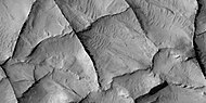
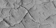
Linear ridge networks
Linear ridge networks are found in various places on Mars in and around craters.[8] Ridges often appear as mostly straight segments that intersect in a lattice-like manner. They are hundreds of meters long, tens of meters high, and several meters wide. It is thought that impacts created fractures in the surface, these fractures later acted as channels for fluids. Fluids cemented the structures. With the passage of time, surrounding material was eroded away, thereby leaving hard ridges behind. Since the ridges occur in locations with clay, these formations could serve as a marker for clay which requires water for its formation.[9][10][11] Water here could have supported past life in these locations. Clay may also preserve fossils or other traces of past life.
-
 Narrow ridges, as seen by HiRISE under HiWish program. The ridges may be the result of impacts fracturing the surface.
 -
 Linear ridge networks, as seen by HiRISE under HiWish program
 -
 Close-up of ridge network, as seen by HiRISE under HiWish program This is an enlargement of a previous image.
 -
 Close-up of ridge network, as seen by HiRISE under HiWish program This is an enlargement of a previous image.
 -
 Linear ridge networks, as seen by HiRISE under HiWish program


-
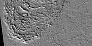
 Wide view of polygon ridges, as seen by HiRISE under HiWish program
 -
 Polygonal ridges, as seen by HiRISE under HiWish program
 -
 Polygonal ridges, as seen by HiRISE under HiWish program
 -
 Polygonal ridges, as seen by HiRISE under HiWish program
 -
 Close view of polygonal ridges, as seen by HiRISE under HiWish program
 -
 Close, color view of polygonal ridges, as seen by HiRISE under HiWish program


-
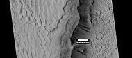
 Wide view of large ridge network, as seen by HiRISE under HiWish program
 -
 Close view of ridge network, as seen by HiRISE under HiWish program Box shows size of football field.
 -
 Close, color view of ridges, as seen by HiRISE under HiWish program


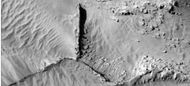
Streamlined shapes
When a fluid moves by a feature like a mound, it will become streamlined. Often flowing water makes the shape and later lava flows spread over the region. In the pictures below this has occurred.
-
 Wide view of streamlined shape and rafts of lava, as seen by HiRISE under HiWish program
 -
 Closer view of previous image, showing layers, as seen by HiRISE under HiWish program
 -
 Close view of lava rafts from previous images, as seen by HiRISE under HiWish program
 -
 Streamlined Island inPettit Crater. Scale bar is 500 meters long.
 -
 Streamlined shape showing layers, as seen by HiRISE under HiWish program.


Lava flows
-
 Lava flows affected by obstacles, as seen by HiRISE under HiWish program Arrows show two obstacles that are changing the flow.
 -
 View of a lava lobe, as seen by HiRISE under HiWish program The box shows the size of a football field.
 -
 Close view of a lava lobe, as seen by HiRISE under HiWish program The box shows the size of a football field.


Dark slope streaks
Many places on
It is most generally accepted that the streaks represent avalanches of dust. Streaks appear in areas covered with dust. When a thin layer of dust is removed, the underlying surface appears dark. Much of the Martian surface is covered with dust. Dust storms are frequent, especially when the spring season begins in the southern hemisphere. At that time, Mars is 40% closer to the Sun. The orbit of Mars is much more elliptical than the Earth's. That is, the difference between the farthest point from the Sun and the closest point to the Sun is very great for Mars, but only slight for the Earth. Also, every few years, the entire planet is engulfed in a global dust storm. When NASA's Mariner 9 craft arrived there, nothing could be seen through the dust storm.[16][17] Other global dust storms have also been observed, since that time.
-
 Layers in Gordii Dorsum Region, as seen by HiRISE under HiWish program. Dark lines areDark Slope Streaks.
 -
 Dark slope streaks on mesa, as seen by HiRISE under HiWish program Location is Amazonis quadrangle.
 -
 Dark slope streaks on mound in Lycus Sulci, as seen by HiRISE under HiWish program


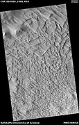
Brain terrain
Brain terrain is common in many places on Mars. It is formed when ice sublimates along cracks. The ridges of brain terrain may contain a core of ice. Shadow measurements from HiRISE indicate the ridges are 4–5 meters high.[18]
-
 Wide view of brain terrain, as seen by HiRISE under HiWish program
 -
 Close view of brain terrain, as seen by HiRISE under HiWish program
 -
 Close, color view of brain terrain, as seen by HiRISE under HiWish program


More Images from Amazonis Planitia
-
 MOLA map showing boundaries for Amazonis Planitia and other regions Colors indicate elevations.
 -
 Martian Dust Devil - in Amazonis Planitia (April 10, 2001) (also) (video (02:19)).
 -
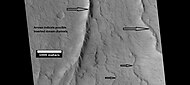 Possible inverted stream channels in Phlegra Dorsa region, as seen by HiRISE under HiWish program. The ridges were probably once stream valleys that have become full of sediment and cemented. So, they became hardened against erosion which removed surrounding material.
 -
 Surfaces in Amazonis quadrangle, as seen by HiRISE under HiWish program.
 -
 Layered features in Lycus Sulci, as seen by HiRISE under HiWish program
 -
 Wide view of scarp showing layers, as seen by HiRISE under HiWish program
 -
 Close view of layers from previous image, as seen by HiRISE under HiWish program
 -
 Layers in trough and dark slope streaks, as seen by HiRISE under HiWish program
 -
 Pedestal crater with layers, as seen by HiRISE under HiWish program


Interactive Mars map

See also
- Amazonian (Mars)
- Dark slope streaks
- Geography of Mars
- List of plains on Mars
- Medusae Fossae Formation
References
- ^ E. R. Fuller and J. W. Head, III, "GEOLOGIC HISTORY OF THE SMOOTHEST PLAINS ON MARS (AMAZONIS PLANITIA) AND ASTROBIOLOGICAL IMPLICATIONS." Lunar and Planetary Science XXXIII (2002). URL accessed 19 April 2006.
- ^ Hartmann, William. A Traveler's Guide to Mars: The Mysterious Landscapes of the Red Planet. Workman Publishing: New York, 2003.
- ^ Hartmann, 275.
- ^ Hartmann, 286.
- ^ Fuller, E.R. and J.W. Head III (2002), Amazonis Planitia: The role of geologically recent volcanism and sedimentation in the formation of the smoothest plains on Mars.
- ^ Hartmann, 287.
- ^ Grotzinger, J. and R. Milliken (eds.) 2012. Sedimentary Geology of Mars. SEPM
- ^ Head, J., J. Mustard. 2006. Breccia dikes and crater-related faults in impact craters on Mars: Erosion and exposure on the floor of a crater 75 km in diameter at the dichotomy boundary, Meteorit. Planet Science: 41, 1675-1690.
- ^ Mangold et al. 2007. Mineralogy of the Nili Fossae region with OMEGA/Mars Express data: 2. Aqueous alteration of the crust. J. Geophys. Res., 112, doi:10.1029/2006JE002835.
- ^ Mustard et al., 2007. Mineralogy of the Nili Fossae region with OMEGA/Mars Express data: 1. Ancient impact melt in the Isidis Basin and implications for the transition from the Noachian to Hesperian, J. Geophys. Res., 112.
- ^ Mustard et al., 2009. Composition, Morphology, and Stratigraphy of Noachian Crust around the Isidis Basin, J. Geophys. Res., 114, doi:10.1029/2009JE003349.
- ^ http://www.space.com/scienceastronomy/streaks_mars_021200.html[permanent dead link]
- ^ "Archived copy". Archived from the original on 2015-02-21. Retrieved 2010-12-19.
{{cite web}}: CS1 maint: archived copy as title (link) - ^ http://www.space.com/scienceastronomy/streaks_mars_streaks_030328.html[permanent dead link]
- ^ "Mars Spirit Rover Gets Energy Boost from Cleaner Solar Panels".
- ISBN 0-517-00192-6.
- ISBN 978-0-8165-1257-7. Retrieved 7 March 2011.
- ^ Levy, J., J. Head, D. Marchant. 2009. Concentric crater fill in Utopia Planitia: History and interaction between glacial “brain terrain” and periglacial mantle processes. Icarus 202, 462–476.