
Memnonia quadrangle
 Map of Memnonia quadrangle from Mars Orbiter Laser Altimeter (MOLA) data. The highest elevations are red and the lowest are blue. | |
| Coordinates | 15°00′S 157°30′W / 15°S 157.5°W |
|---|---|
The Memnonia quadrangle is one of a series of 30 quadrangle maps of Mars used by the United States Geological Survey (USGS) Astrogeology Research Program. The Memnonia quadrangle is also referred to as MC-16 (Mars Chart-16).[1]
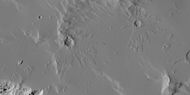
The quadrangle is a region of Mars that covers latitude -30° to 0° and longitude 135° to 180°.[2] The western part of Memnonia is a highly cratered highland region that exhibits a large range of crater degradation.
Memnonia includes these topographical regions of Mars:
Recently, evidence of water was found in the area. Layered sedimentary rocks were found in the wall and floor of
Many ancient river
Layers
Scientists are excited about finding hydrated minerals such as
Rock can form layers in a variety of ways. Volcanoes, wind, or water can produce layers.[10]
-
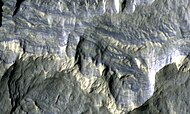 Columbus Crater Layers, as seen by HiRISE. This false-color image is about 800 feet across. Some of the layers contain hydrated minerals such as clay and sulfates.
 -
 Layers in Monument Valley. These are accepted as being formed, at least in part, by water deposition. Since Mars contains similar layers, water remains as a major cause of layering on Mars.
 -
 Layers in crater wall, as seen by HiRISE under HiWish program
 -
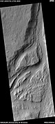
 Layers exposed at the base of a group of buttes in Mangala Valles in Memnonia quadrangle, as seen by HiRISE under HiWish program. Arrows point to boulders sitting in pits. The pits may have formed by winds, heat from the boulders melting ground ice, or some other process.
 -
 Crater displaying layers, as seen by HiRISE under HiWish program
 -
 Valley, as seen by HiRISE under HiWish program


Mangala Vallis
Mangala Vallis is a major channel system that contains several basins which filled, then the overflow went through a series of spillways.[11][12] One source of waters for the system was Memonia Fossae, but water also probably came from a large basin centered at 40 degrees S.[13][14]
-
 Mangala Valles, as seen by HiRISE.
 -
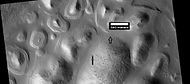
 Mangala Vallis with a streamlined island, as seen by THEMIS
 -
 Streamlined feature in Mangala Vallis, as seen by HiRISE under HiWish program. Manydark slope streaksare visible. Location is Memnonia quadrangle.
 -
 Part of Mangala Valles, as seen by HiRISE under HiWish program. Location is Memnonia quadrangle.


Craters
Impact craters generally have a rim with ejecta around them, in contrast volcanic craters usually do not have a rim or ejecta deposits. As craters get larger (greater than 10 km in diameter) they usually have a central peak.[15] The peak is caused by a rebound of the crater floor following the impact.[16] Sometimes craters will display layers. Since the collision that produces a crater is like a powerful explosion, rocks from deep underground are tossed unto the surface. Hence, craters can show us what lies deep under the surface. At times, bright rays surround craters because the impact has gone down to a bright layer of rocks, then thrown out the bright rocks on the darker surface. An image below from Mars Global Surveyor shows this.
-
 Bright rays caused by impact throwing out a bright lower layer. Some bright layers contain hydrated minerals. Picture taken with Mars Global Surveyor, under the MOC Public Targeting Program.
 -
 Small craters with thin ejecta, as seen by HiRISE under HiWish program
 -
 Close-up of Columbus Crater, as seen by HiRISE
 -
 Nicholson CraterCentral Mound, as seen by HiRISE. Click on image to see dark slope streak being diverted by an obstacle.
 -
 Bernard CraterFloor, as seen by HiRISE. Large cracks are visible on floor.
 -
 Troughs on the floor ofBernard Cratershowing many boulders, as seen by HiRISE under HiWish program
 -
 Troughs on the floor ofBernard Crater, as seen by HiRISE under HiWish program
 -
 Dejnev CraterFloor, as seen by HiRISE. Scale bar is 500 meters long. Click on image to see large pits.
 -
 Erosion of crater deposit in Lucus Planum, as seen by HiRISE under HiWish program
 -
 Close-up of layers in a pit on crater floor, as seen by HiRISE under HiWish program
 -
 Williams Crater, as seen by CTX camera (on Mars Reconnaissance Orbiter)
 -
 Middle section ofBurton Crater, showing central mound, as seen by CTX camera (on Mars Reconnaissance Orbiter)
 -
 Central mound of Burton Crater, showingdark slope streaks, as seen by CTX camera (on Mars Reconnaissance Orbiter). Note: this is an enlargement of the previous image of Burton Crater.
 -
 East side ofEjriksson Crater, as seen by CTX camera (on Mars Reconnaissance Orbiter)


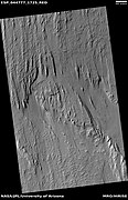
Ridges
Ridges on Mars may be due to different causes. Long straight ridges are thought to be dikes. Curved and branched ridges may be examples of
-
 Wide view of region that displays ridges when enlarged. Picture taken with HiRISE under HiWish program.
 -
 Close view of ridges, as seen by HiRISE under HiWish program. Arrows point to some ridges.
 -
 Close view of ridges, as seen by HiRISE under HiWish program
 -
 Close view of ridges, as seen by HiRISE under HiWish program. Arrows point to some straight ridges.
 -
 Close view of ridges, as seen by HiRISE under HiWish program
 -
 Straight lines and ridges, as seen by HiRISE under HiWish program


Yardangs
Yardangs are common in some regions on Mars, especially in what is called the "Medusae Fossae Formation."[18] They are formed by the action of wind on sand sized particles; hence they often point in the direction that the winds were blowing when they were formed.
-
 Wide view of yardangs in Lucus Planum, as seen by HiRISE under HiWish program
 -
 Close view of yardangs in previous image, as seen by HiRISE under HiWish program
 -
 Close view of yardangs from a previous image, as seen by HiRISE under HiWish program
 -
 Close up of crater floor showing yardangs and dark slope streaks, as seen by HiRISE under HiWish program
 -
 Yardangs, as seen by HiRISE under HiWish program
 -
 Yardangs, as seen by HiRISE under HiWish program
 -
 Wide view of yardangs, as seen by HiRISE under HiWish program. This image is odd in that the yardangs are lined up in different directions in the top and bottom part of image. The wind direction probably changed to cause this.


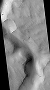
Dark slope streaks
Many places on Mars show
It is most generally accepted that the streaks represent avalanches of dust.
Research, published in January 2012 in Icarus, found that dark streaks were initiated by airblasts from meteorites traveling at supersonic speeds. The team of scientists was led by Kaylan Burleigh, an undergraduate at the University of Arizona. After counting some 65,000 dark streaks around the impact site of a group of five new craters, patterns emerged. The number of streaks was greatest closer to the impact site. So, the impact somehow probably caused the streaks. Also, the distribution of the streaks formed a pattern with two wings extending from the impact site. The curved wings resembled scimitars, curved knives. This pattern suggests that an interaction of airblasts from the group of meteorites shook dust loose enough to start dust avalanches that formed the many dark streaks. At first it was thought that the shaking of the ground from the impact caused the dust avalanches, but if that was the case the dark streaks would have been arranged symmetrically around the impacts, rather than being concentrated into curved shapes.[26][27]
-
 Minio Vallis Hanging Valleys, as seen by HiRISE. Two hanging valleys are visible, as well as many dark slope streaks.
 -
 Tinia Valles, as seen by HiRISE. Full size image shows dark slope streaks.
 -
 Labou Vallis, as seen by HiRISE. Ful size image shows old and new (darker) dark slope streaks.
 -
 Dark slope streaks, as seen by HiRISE under HiWish program
 -
 Dark slope streaks, as seen by HiRISE under HiWish program
 -
 Dark slope streaks, as seen by HiRISE under HiWish program


Fossa on Mars
Large troughs (long narrow depressions) are called fossae in the geographical language used for Mars. This term is derived from Latin; therefore fossa is singular and fossae is plural.
Other ideas have been suggested for the formation of fossae. There is evidence that they are associated with dikes of magma. Magma might move along, under the surface, breaking the rock and more importantly melting ice. The resulting action would cause a crack to form at the surface. Dikes caused both by tectonic stretching (extension) and by dikes are found in Iceland.[30] An example of a graben caused by a dike is shown below in the image Memnonia Fossae, as seen by HiRISE.
It appears that the water started coming out of the surface to form Mangala Vallis when a graben was formed.[4][31]
-
 Graben in Memnonia Fossae, as seen by HiRISE. This graben is believed to be the result of magmatic dikes rather than regional tectonic stretching. The scale bar is 1000 meters long.
 -
 Fossa (geology).
 -
 Large pits in Sirenum Fossae, as seen by HiRISE under HiWish program
 -
 Trough cutting through an impact crater, as seen by HiRISE under HiWish program


Valles
There is enormous evidence that water once flowed in river valleys on Mars. Images of curved channels have been seen in images from Mars spacecraft dating back to the early 1970s with the Mariner 9 orbiter.[32][33][34][35] Vallis (plural valles) is the
-
 Asopus Vallis, as seen by HiRISE
 -
 Samara Valles, as seen by HiRISE. Scale bar is 500 meters long.
 -
 Padus Vallis, as seen by THEMIS. Padus Vallis empties into the Medusae Fossae Formation.
 -
 Close-up of Padus Vallis, as seen by THEMIS
 -
 Mangala Vallis.
 -
 Minio Vallis, as seen by HiRISE under HiWish program. Manydark slope streaksare present.
 -
 Sabis Vallis, as seen by THEMIS. The small channels are joining to form Sabis Vallis.
 -
 Channel showing an old oxbow and a cutoff, as seen by HiRISE under HiWish program
 -
 Wide view of channel, as seen by HiRISE under HiWish program
 -
 Channel with yardangs, as seen by HiRISE under HiWish program
 -
 Channel withdark slope streaksas seen by HiRISE under HiWish program
 -
 Enlargement of the previous image, as seen by HiRISE under HiWish program
 -
 as seen by HiRISE under HiWish program
 -
 Streamlined forms in a channel, as seen by HiRISE under HiWish program
 -
 Curved valley, as seen by HiRISE under HiWish program


Lava flows
Lava is common on Mars, as it is on many other planetary bodies.
-
 Lava flow. Lava flow stopped when it encountered the higher ground of a mound. Picture was taken with HiRISE under HiWish program.

Fifty Years of Mars Imaging: from Mariner 4 to HiRISE
On October 3, 2017, HiRISE acquired a picture of Mars in the Memnonia quadrangle of a spot that has been imaged by seven different cameras on different spacecraft over the past 50 years.[40] The pictures from the Red Planet started with one of the pictures from Mariner 4 in the summer of 1965. The following pictures show these pictures with their increasing resolution over the years. The resolution in the first image by Mariner 4 was 1.25 km/pixel; that compares to the approximate 50 cm/pixel resolution of HiRISE.
-
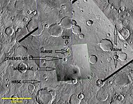 Composite demonstrating relative resolution of seven different cameras that imaged Mars:Mars Odyssey), MOC-WAC (Mars Global Surveyor), HRSC (Mars Express), CTX (Mars Reconnaissance Orbiter), Viking, Mariner 4. Location is Memnonia quadrangle.
 -
 Composite demonstrating relative resolution of seven different cameras that imaged Mars: HiRISE (Mars Reconnaissance Orbiter), THEMIS VIS (Mars Odyssey), MOC-WAC (Mars Global Surveyor), HRSC (Mars Express), CTX (Mars Reconnaissance Orbiter), Viking, Mariner 4. Location is Memnonia quadrangle. Blue arrow on some pictures points to same location at with different cameras. Red box with CTX image shows location of the next frame from HiRISE.


-
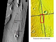
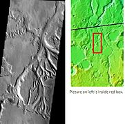
 Map showing area covered in the above photos with a black rectangle. Blue arrow indicates the spot eventually imaged by HiRISE. The relative positions ofBernard Craterare shown.

More features
-
 Surface features along a scarp in Medusae Fossae formation, as seen by HiRISE under HiWish program. Location is Memnonia quadrangle.
 -
 Channels inside and outside of a crater, as seen by HiRISE under HiWish program. Branched channels are outside the crater (at the top of the image). The channel then goes into crater, making more branches that are probably on a delta-like form.
 -
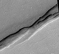
 Channel that has eroded through a wrinkle ridge, as seen by HiRISE under HiWish program. Arrow shows point where channel eroded through ridge.
 -
 Streamlined feature, as seen by HiRISE under HiWish program
 -
 Wide view of layers in crater, as seen by HiRISE under HiWish program
 -
 Close view of layers in crater, as seen by HiRISE under HiWish program
 -
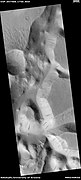
 Close view of boulders sitting in pits, as seen by HiRISE under HiWish program
 -
 Exhumed crater, as seen by HiRISE under HiWish program. After its formation, the crater was buried, now it is being exposed by erosion.


Other Mars quadrangles

Interactive Mars map

See also
- Climate of Mars
- Dark slope streaks
- Fossa (geology)
- Geology of Mars
- Groundwater on Mars
- HiRISE
- High Resolution Stereo Camera - HRSC
- HiWish program
- Impact crater
- Lakes on Mars
- List of quadrangles on Mars
- Linear ridge networks
- Lucus Planum
- Mariner 4
- Mars Express
- Mars Global Surveyor
- Mars Orbiter Camera
- Mars Orbiter Mission
- 2001 Mars Odyssey
- MAVEN
- Thermal Emission Imaging System- THEMIS
- Viking program
- Vallis
- Valley networks (Mars)
- Water on Mars
- Yardang
- Yardangs on Mars
References
- ^ Davies, M.E.; Batson, R.M.; Wu, S.S.C. "Geodesy and Cartography" in Kieffer, H.H.; Jakosky, B.M.; Snyder, C.W.; Matthews, M.S., Eds. Mars. University of Arizona Press: Tucson, 1992.
- ^ USGS Astrogeology: Planetary Map Listing
- ^ "HiRISE | Sedimentary Layers in Columbus Crater (PSP_010281_1510)". Hirise.lpl.arizona.edu. Retrieved 2012-08-04.
- ^ a b "Mars Channels and Valleys". Msss.com. Retrieved 2012-08-04.
- ^ Cabrol, N. and E. Grin (eds.). 2010. Lakes on Mars. Elsevier.NY.
- ^ Wray, J. et al. 2009. Columbus Crater and other possible plaelakes in Terra Sirenum, Mars. Lunar and Planetary Science Conference. 40: 1896.
- ^ "Martian "Lake Michigan" Filled Crater, Minerals Hint". News.nationalgeographic.com. 2010-10-28. Archived from the original on December 5, 2009. Retrieved 2012-08-04.
- ^ "Target Zone: Nilosyrtis? | Mars Odyssey Mission THEMIS". Themis.asu.edu. Retrieved 2012-08-04.
- ^ "HiRISE | Craters and Valleys in the Elysium Fossae (PSP_004046_2080)". Hirise.lpl.arizona.edu. Retrieved 2012-08-04.
- ^ "HiRISE | High Resolution Imaging Science Experiment". Hirise.lpl.arizona.edu?psp_008437_1750. Retrieved 2012-08-04.
- ^ Cabrol, N. and E. Grin (eds.). 2010. Lakes on Mars. Elsevier. NY.
- ^ Emrick, C. and R. De Hon. 1999. Flood discharge through Labou Vallis, Mars. Lunar Planet. Sci. Conf. XXX: Abstract #1893.
- ^ Zimbelman, J. et al. 1992. Volatile history of Mangala Valles, Mars. J. Geophys. Res. 97: 18309-18317
- ^ De Hon, R. 1994. Lacustrine sedimentation in lower Mangals Valles. Mars Lunar Planet. Sci. Conf. XXVII: 295-296
- ^ "Stones, Wind, and Ice: A Guide to Martian Impact Craters". Lpi.usra.edu. Retrieved 2012-08-04.
- ^ ISBN 978-0-8165-1257-7. Retrieved 7 March 2011.
- ^ Head, J., J. Mustard. 2006. Breccia dikes and crater-related faults in impact craters on Mars: Erosion and exposure on the floor of a crater 75 km in diameter at the dichotomy boundary, Meteorit. Planet Science: 41, 1675-1690.
- ^ SAO/NASA ADS Astronomy Abstract Service: Yardangs on Mars
- ^ Schorghofer, N, et al. 2007. Three decades of slope streak activity on Mars. Icarus. 191:132-140.
- ^ http://www.space.com/scienceastronomy/streaks_mars_021200.html [dead link]
- ^ www.spcae.com https://web.archive.org/web/20150221231430/http://www.spcae.com/scienceastronomy/streaks_mars_021211.html. Archived from the original on February 21, 2015.
{{cite web}}: Missing or empty|title=(help) - ^ http://www.space.com/scienceastronomy/streaks_mars_streaks_030328.html [dead link]
- ^ "Mars Spirit Rover Gets Energy Boost From Cleaner Solar Panels". Sciencedaily.com. 2009-02-19. Retrieved 2012-08-04.
- ISBN 0-517-00192-6.
- ^ "Red Planet Report | What's up with Mars". Redplanet.asu.edu. Retrieved 2012-08-04.
- ^ "Mars Art Gallery Martian Feature Name Nomenclature". Marsartgallery.com. Retrieved 2012-08-04.
- ^ "HiRISE | Craters and Pit Crater Chains in Chryse Planitia (PSP_008641_2105)". Hirise.lpl.arizona.edu. Retrieved 2012-08-04.
- ^ "HiRISE | Graben in Memnonia Fossae (PSP_005376_1575)". Hirise.lpl.arizona.edu. Retrieved 2012-08-04.
- ISBN 978-0-521-87201-0. Retrieved 21 March 2011.
- ^ Baker, V. 1982. The Channels of Mars. Univ. of Tex. Press, Austin, TX
- ^ Baker, V., R. Strom, R., V. Gulick, J. Kargel, G. Komatsu, V. Kale. 1991. Ancient oceans, ice sheets and the hydrological cycle on Mars. Nature 352, 589–594.
- ^ Carr, M. 1979. Formation of Martian flood features by release of water from confined aquifers. J. Geophys. Res. 84, 2995–300.
- ^ Komar, P. 1979. Comparisons of the hydraulics of water flows in Martian outflow channels with flows of similar scale on Earth. Icarus 37, 156–181.
- ^ Raeburn, P. 1998. Uncovering the Secrets of the Red Planet Mars. National Geographic Society. Washington D.C.
- ^ Moore, P. et al. 1990. The Atlas of the Solar System. Mitchell Beazley Publishers NY, NY.
- ^ Carr, M. 1979. Formation of martian flood features by release of water from confined aquifers. J. Geophys. Res. 84: 2995-3007.
- ^ Hanna, J. and R. Phillips. 2005. Tectonic pressurization of aquifers in the formation of Mangala and Athabasca Valles on Mars. LPSC XXXVI. Abstract 2261.
- ^ "HiRISE | Fifty Years of Mars Imaging: From Mariner 4 to HiRISE (ESP_052438_1560)".
- ISBN 0-312-24551-3.
- ^ "Online Atlas of Mars". Ralphaeschliman.com. Retrieved December 16, 2012.
- ^ "PIA03467: The MGS MOC Wide Angle Map of Mars". Photojournal. NASA / Jet Propulsion Laboratory. February 16, 2002. Retrieved December 16, 2012.