Amt Beetzsee

Coordinates: 52°26′58″N 12°32′23″E / 52.449444°N 12.539722°E / 52.449444; 12.539722
Source: Wikipedia, the free encyclopedia.

Amt Beetzsee is an

Amt ("collective municipality") in the district of Potsdam-Mittelmark, in Brandenburg, Germany
. Its seat is in Beetzsee.

The Amt Beetzsee consists of the following municipalities:

  1. Beetzsee
  2. Beetzseeheide
  3. Havelsee
  4. Päwesin
  5. Roskow

Demography

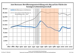
  • Development of population since 1875 within the current Boundaries (Blue Line: Population; Dotted Line: Comparison to Population development in Brandenburg state; Grey Background: Time of Nazi Germany; Red Background: Time of communist East Germany)
    Development of population since 1875 within the current Boundaries (Blue Line: Population; Dotted Line: Comparison to Population development in Brandenburg state; Grey Background: Time of Nazi Germany; Red Background: Time of communist East Germany)
  • Recent Population Development and Projections (Population Development before Census 2011 (blue line); Recent Population Development according to the Census in Germany in 2011 (blue bordered line); Official projections for 2005-2030 (yellow line); for 2017-2030 (scarlet line); for 2020-2030 (green line)
    Recent Population Development and Projections (Population Development before Census 2011 (blue line); Recent Population Development according to the Census in Germany in 2011 (blue bordered line); Official projections for 2005-2030 (yellow line); for 2017-2030 (scarlet line); for 2020-2030 (green line)
Amt Beetzsee: Population development
within the current boundaries (2020)[1]
YearPop.±% p.a.
1875 8,712—    
1890 9,402+0.51%
1910 8,990−0.22%
1925 8,871−0.09%
1939 9,351+0.38%
1950 11,689+2.05%
1964 8,836−1.98%
YearPop.±% p.a.
1971 8,657−0.29%
1981 7,443−1.50%
1985 7,183−0.88%
1990 6,846−0.96%
1995 7,296+1.28%
2000 8,892+4.04%
2005 8,666−0.51%
YearPop.±% p.a.
2010 8,473−0.45%
2015 8,141−0.80%
2016 8,205+0.79%
2017 8,192−0.16%
2018 8,261+0.84%
2019 8,307+0.56%
2020 8,295−0.14%

References

  1. ^ Detailed data sources are to be found in the Wikimedia Commons.Population Projection Brandenburg at Wikimedia Commons

52°26′58″N 12°32′23″E / 52.449444°N 12.539722°E / 52.449444; 12.539722