Amt Temnitz

Coordinates: 52°56′21″N 12°40′12″E / 52.939222°N 12.669889°E / 52.939222; 12.669889
Source: Wikipedia, the free encyclopedia.

Amt Temnitz is an

collective municipality") in the district of Ostprignitz-Ruppin, in Brandenburg, Germany
. Its seat is in Walsleben.

The Amt Temnitz consists of the following municipalities:

  1. Dabergotz
  2. Märkisch Linden
  3. Storbeck-Frankendorf
  4. Temnitzquell
  5. Temnitztal
  6. Walsleben

Demography

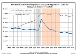
  • Development of population since 1875 within the current Boundaries (Blue Line: Population; Dotted Line: Comparison to Population development in Brandenburg state; Grey Background: Time of Nazi Germany; Red Background: Time of communist East Germany)
    Development of population since 1875 within the current Boundaries (Blue Line: Population; Dotted Line: Comparison to Population development in Brandenburg state; Grey Background: Time of Nazi Germany; Red Background: Time of communist East Germany)
  • Recent Population Development and Projections (Population Development before Census 2011 (blue line); Recent Population Development according to the Census in Germany in 2011 (blue bordered line); Official projections for 2005-2030 (yellow line); for 2017-2030 (scarlet line); for 2020-2030 (green line)
    Recent Population Development and Projections (Population Development before Census 2011 (blue line); Recent Population Development according to the Census in Germany in 2011 (blue bordered line); Official projections for 2005-2030 (yellow line); for 2017-2030 (scarlet line); for 2020-2030 (green line)
Amt Temnitz: Population development
within the current boundaries (2020)[1]
YearPop.±% p.a.
1875 7,412—    
1890 7,509+0.09%
1910 6,798−0.50%
1925 7,105+0.29%
1939 6,677−0.44%
1950 10,356+4.07%
1964 7,202−2.56%
YearPop.±% p.a.
1971 6,975−0.46%
1981 6,003−1.49%
1985 5,918−0.36%
1990 5,760−0.54%
1995 5,699−0.21%
2000 5,874+0.61%
2005 5,724−0.52%
YearPop.±% p.a.
2010 5,478−0.87%
2015 5,284−0.72%
2016 5,266−0.34%
2017 5,270+0.08%
2018 5,294+0.46%
2019 5,384+1.70%
2020 5,479+1.76%

References

  1. ^ Detailed data sources are to be found in the Wikimedia Commons.Population Projection Brandenburg at Wikimedia Commons

52°56′21″N 12°40′12″E / 52.939222°N 12.669889°E / 52.939222; 12.669889