
Barnim
This article needs additional citations for verification. (March 2013) |
Barnim | |
|---|---|
 Flag  Coat of arms | |
 | |
| Country | Germany |
| State | Brandenburg |
| Capital | Eberswalde |
| Government | |
| • District admin. | Daniel Kurth (SPD) |
| Area | |
| • Total | 1,494 km2 (577 sq mi) |
| Population (31 December 2022)[1] | |
| • Total | 191,849 |
| • Density | 130/km2 (330/sq mi) |
| Time zone | UTC+01:00 (CET) |
| • Summer (DST) | UTC+02:00 (CEST) |
| Vehicle registration | BAR, BER, EW |
| Website | www.barnim.de |
Barnim (German pronunciation: [ˈbaʁnɪm] ⓘ) is a district in Brandenburg, Germany. It is bounded by (from the east and clockwise) Poland, the district of Märkisch-Oderland, the city state of Berlin and the districts of Oberhavel and Uckermark.
History
The name "Barnim" emerged in the 13th century and was applied to a large forest region east of the Havel and north of the Spree on the homonymous plateau, where noblemen used to hunt. The present district is roughly identical with, but somewhat smaller than this historical region.
The district was established in 1993 by merging the former districts of Bernau and Eberswalde.
Geography
Barnim extends from the
Demography
-
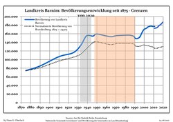 Development of Population since 1875 within the Current Boundaries (Blue Line: Population; Dotted Line: Comparison to Population Development of Brandenburg state; Grey background: Time of Nazi rule; Red background: Time of communist rule)
 -
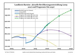 Recent Population Development and Projections (Population Development before Census 2011 (blue line); Recent Population Development according to the Census in Germany in 2011 (blue bordered line); Official projections for 2005-2030 (yellow line); for 2014-2030 (red line); for 2017-2030 (scarlet line)


|
|
|
Coat of arms

The coat of arms of the district resembles the coat of arms of the former district Oberbarnim. The only difference is that the old one had a silver top half and a red bottom half, while the current one is split into four parts and in the right half exchanged red and silver. The eagle in the top half is the eagle of Brandenburg.
Towns and municipalities
| Amt-free towns | Ämter
|
|
|---|---|---|
|
|
||
| 1seat of the Amt; 2town | ||
References
- Amt für Statistik Berlin-Brandenburg(in German). June 2023.
- ^ Detailed data sources are to be found in the Wikimedia Commons.Population Projection Brandenburg at Wikimedia Commons
External links
![]() Media related to Barnim at Wikimedia Commons
Media related to Barnim at Wikimedia Commons
- Official website (in German)
| Urban districts | |
|---|---|
| Rural districts | |
52°50′N 13°45′E / 52.833°N 13.750°E
| International | |
|---|---|
| National | |