Bear's Paw
| Bear's Paw | |
|---|---|
| Hanging Rock | |
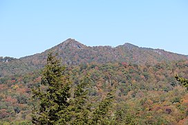
 Peak Mountain (left) and Bear's Paw (right) viewed from Grandfather Mountain | |
| Highest point | |
| Elevation | 5,203 ft (1,586 m)[1] |
| Prominence | 1,080 ft (330 m)[2] |
| Coordinates | 36°09′13″N 81°49′27″W / 36.15361°N 81.82417°W[1] |
| Geography | |
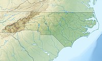
| Location | Avery / Watauga counties, North Carolina, U.S. |
| Parent range | Blue Ridge Mountains |
| Topo map | USGS Valle Crucis |
Hanging Rock, also known as Bear's Paw (Yonah‑wayah in
Elk and Watauga
rivers.
In 2008, Bear Paw State Natural Area was established on the mountain by the
Grandfather Mountain State Park
.
See also
References
- ^ a b "Hanging Rock". Geographic Names Information System. United States Geological Survey, United States Department of the Interior. Retrieved December 29, 2009.
- ^ "Hanging Rock". Peakbagger.com. Retrieved December 31, 2009.
- ^ a b
"Session Law 2008-155". Raleigh, North Carolina: General Assembly of North Carolina. June 19, 2003. Retrieved September 13, 2011.
[T]his site was known by the Cherokee as Yonah‑wayah, or Bear's Paw[.]
- ^ "Bear Paw and Yellow Mountain State Natural Areas Authorized". ncparks.gov. N.C. Department of Environment and Natural Resources. August 5, 2008. Retrieved September 13, 2011.
- ^ "Size of the North Carolina State Parks System". North Carolina Division of Parks and Recreation. January 1, 2015. Archived from the original (XLS) on October 4, 2015. Retrieved September 2, 2015.
External links
- Bear Paw SNA Map by the Town of Seven Devils.


