
Mount Pisgah (mountain in North Carolina)
| Mount Pisgah | |
|---|---|
_Oct_2016.jpg) View of Mount Pisgah from the Blue Ridge Parkway, October 2016 | |
| Highest point | |
| Elevation | 5,721 ft (1,744 m) |
| Coordinates | 35°25′32″N 82°45′25″W / 35.4255°N 82.7569°W |
| Geography | |
| Location | Buncombe / Haywood counties, North Carolina, U.S. |
| Parent range | Appalachian Mountains |
| Topo map | USGS Cruso |
| Climbing | |
| Easiest route | Hike |
Mount Pisgah is a mountain in the Appalachian mountain range and part of the Blue Ridge Mountains of North Carolina, United States. The mountain's height is 5,721 feet (1,744 m) above sea level, and it sits approximately 15 miles (24 kilometers) southwest of Asheville, near the crossing of the boundaries of Buncombe, Haywood, Henderson and Transylvania counties. It is located on the border of Buncombe and Haywood counties, close to the point where Henderson and Transylvania meet them, but not actually within the latter two counties. The mountain is easily accessible via a hiking trail from the Blue Ridge Parkway, near the Pisgah Inn.
Broadcasting controversy
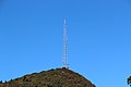
The prominent tower in the picture at the crest of Mount Pisgah, on what is known as Pisgah Ledge, is a 339-foot-tall (103 m) television
On May 22, 2001, the
Recreation
The trail leading to the summit of Mt. Pisgah starts at
Leading up the mountain from the valley floor, is a still-operating cable car that is used to ferry broadcasting equipment to the building. The cable car also ferries engineers during bad weather, for mandatory transmitter work.
Also at the Mt. Pisgah Parking area is the Buck Spring
On the east side of the Parkway at
The Pisgah Inn Lodge Restaurant and Country Store, as well as the Mt. Pisgah
Gallery
-
 View from Black Balsam Knob, 9.5 miles distant
 -
 Viewed from North Carolina Highway 151
 -
 Mount Pisgah summit, with radio tower


See also
References
External links
 Media related to Mount Pisgah (North Carolina) at Wikimedia Commons
- Blue Ridge Parkway: Mount Pisgah
- Pisgah Inn
- Pisgah Cable Car