
Bohoniki
Bohoniki | ||
|---|---|---|
Village | ||
Country | ||
| Voivodeship | Podlaskie | |
| County | Sokółka | |
| Gmina | Sokółka | |
| Population | ||
| • Total | 100 | |

Bohoniki [bɔxɔˈniki] (Polish Arabic: بوـحـونيكي) is a village in the administrative district of Gmina Sokółka, within Sokółka County, Podlaskie Voivodeship, in north-eastern Poland, close to the border with Belarus.[1] It lies approximately 7 kilometres (4 mi) east of Sokółka and 42 km (26 mi) north-east of the regional capital Białystok.
Bohoniki was primarily a
Muslims. Although residents don't speak their native Tatar language (often written in Latin, Cyrillic or Arabic alphabet), they have close ties to Lipka Tatar and Islamic traditions.[2]
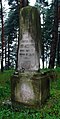
Sites of interest in the village include a 19th-century wooden mosque and a Muslim cemetery.
The village was named one of Poland's official national
National Heritage Board of Poland
.
Muslim cemetery
-
 Entrance
 -
 Muslim Lipka Tatar cemetery sign
 -
 Damaged tombstone
 -
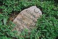 Ruthenian language Arabic script of a tombstone
 -

-

-

-
-


References
Wikimedia Commons has media related to Bohoniki.
- ^ "Central Statistical Office (GUS) - TERYT (National Register of Territorial Land Apportionment Journal)" (in Polish). 2008-06-01.
- ^ Leonard Drożdżewicz (2016). "Biographical Dictionary of Polish Tatars of the Twentieth Century" (PDF). Znad Wilii. 4 (68): 77–82.

| International | |
|---|---|
| National | |
This Sokółka County location article is a stub. You can help Wikipedia by expanding it. |