
Bojacá
Bojacá | |
|---|---|
Municipality and town | |
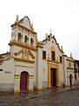
 Church of Bojacá | |
|
UTC-5 (Colombia Standard Time) | |
| Website | Official website |
Bojacá is a municipality and town of the
Madrid and Facatativá in the north, Madrid and Mosquera in the east, Soacha and San Antonio del Tequendama in the south and Tena, La Mesa and Zipacón in the west.[1]
Etymology
The name Bojacá comes from Chibcha and means "Purple enclosure".[1][2]
History
The area around Bojacá was inhabited at least since 3410 years
Muisca
.
On his expedition to El Dorado and after conquering the Muisca, conquistador Gonzalo Jiménez de Quesada founded modern Bojacá on October 16, 1537.[1]
Economy
Main economical activities of Bojacá are
tree tomato and granadilla.[1]
Gallery
-
 Central square
 -
 Church of Bojacá at the central square
 -
 Buste of friar Diego Francisco Pinilla at the central square


References
- ^ a b c d (in Spanish) Official website Bojacá Archived 2017-10-11 at the Wayback Machine
- ^ (in Spanish) Etymology municipalities Cundinamarca - El Tiempo
- ^ Correal Urrego, Gonzalo. 1990. Aguazuque: Evidence of hunter-gatherers and growers on the high plains of the Eastern Ranges, 1-316. Banco de la República: Fundación de Investigaciones Arqueológicas Nacionales. Accessed 2016-07-08.
Wikimedia Commons has media related to Bojacá.
| International | |
|---|---|
| National | |