
Budhabare, Jhapa
Hadiya Budhabare
हडिया बुधवारे | |
|---|---|
Village of UTC+5:45 (NST ) | |
| A.P.O. | 57206 |
| PSTN | 555 |
Budhabare, more specifically Hadiya Budhabare[
As the village is crossed by Hadiya Khola, it is sometimes also referred to as Hadiya Budhabare. The village of Budhabare is best known for two things: the production of
Etymology
The origin of the name budhabare dates back to the early 1940s. Local legend has it that, at that time, an elite man by the name of
Geography
Budhabare is located in
Climate
Since the village lies in the flanks of
Geology
Topographically, Budhabare area lies in the upper Terai region of the Indo-Gangetic plains, almost on the foot of the Siwalik hills. It is generally flat in the south, while the northern part is rolling. The area is dissected by two major streams: Biring Khola and Hadiya Khola. Biring Khola runs from north to south along the western border, serving as a natural demarcation between Budhabare and Khudnabari. Hadiya Khola also runs from north to south, but close to the eastern border. The area close to the two streams is mainly composed of gravel, boulder, and sand. However, the rest and much of Budhabare is primarily composed of silty loamy soil, which is ideal for agriculture.[3]
Demographics
As per the National Population and Housing Census 2011, the total population of the village stands at 22,936, with a male population of 10,938 and a female population of 11,998.[1] In terms of percentage, males constitute some 47.69% and females constitute about 52.31% of the total population. Likewise, the sex ratio is 91.17, which means there are about 91 males for every 100 females in the VDC. The total number of households in the village is 5,270, with an average household size of 4.35. Moreover, the population density of the VDC comes to be around 723 persons per square kilometer, which is about fourfold higher than the national population density.[7]
Age structure
The active population of the VDC is 14,415, which is about 63.29% of the total population. The table immediately below enumerates the population composition of the village on the basis of child dependent, economically active, and old dependent age-group respectively:[7]
| Age Group | Population | Percentage |
|---|---|---|
| 0-14 | 6,170 | 26.90% |
| 15-59 | 14,515 | 63.29% |
| 60+ | 2251 | 9.81% |
Ethnicity
Brahmins who have descended from hills make up about 43.22% of Budhabare's populace. Similarly, Chhetri, Kami, Limbu, Rai, Newar, etc. are also fairly common ethnic groups found in the village. In addition, minority groups residing in the village include Tharu, Muslims, Majhi, Bengali, etc. The table below mentions the major ethnic groups and bulks the minorities into "others," summing up the population composition of Budhabare on ethnicity basis:[7]
| Ethnic Group | Population | Percentage |
|---|---|---|
| Brahmins (Hill) | 9,913 | 43.22% |
| Chhetri | 2,542 | 11.08% |
| Kami | 1,458 | 6.36% |
| Limbu | 1,403 | 6.12% |
| Rai | 1,143 | 4.98% |
| Newar | 1,063 | 4.63% |
| Damai/Dholi | 733 | 3.20% |
| Tamang | 593 | 2.58% |
| Magar | 587 | 2.56% |
| Dhimal | 582 | 2.54% |
Rajbansi |
467 | 2.04% |
| Others | 2,452 | 10.69% |
Language
An overwhelming majority of village population (82.68%) speak Nepali as mother tongue. Other spoken languages include Limbu (4.06%), Dhimal (2.02%), Rai (1.88%), etc. The table below enumerates all languages that at least have a three-digit population:[7]
| Mother Tongue | Population | Percentage |
|---|---|---|
| Nepali | 18,963 | 82.68% |
| Limbu | 932 | 4.06% |
| Dhimal | 464 | 2.02% |
Rai |
432 | 1.88% |
| Tamang | 329 | 1.43% |
| Newari | 300 | 1.31% |
| Rajbansi | 299 | 1.30% |
| Maithili | 287 | 1.25% |
| Magar | 173 | 0.75% |
| Tharu | 125 | 0.54% |
| Bhojpuri | 108 | 0.47% |
| Others | 524 | 2.28% |
Education
As of
Facilities and services
Budhabare is moderately facilitated. For health services, there is a health post located near Budhabare bazaar, which provides basic health care facilities to the local population. In addition to this health post, there also exists an Ayurveda aushadhalaya, which renders basic ayurvedic health facilities. The area has good access to road transport. The Mechi Highway, which connects all the districts of the Mechi zone, runs through the village. It has a network of part black topped and part graveled road within its area. Most areas are thus easily accessible.[3]
Economic activities
The primary economic activity of the village is agriculture. The land is very fertile and the rate of production is good, making this place an "agricultural hotspot" of
Religious sites
Budhabare is home to numerous temple sites that are sacred to Hindu devotees. Pilgrims and worshippers from all over the village and other places flock to these religious spaces during special occasions. Some of the eminent holy places located across the several wards of the village include:
- Ram Janaki Mandir, Budhabare-9
- Shree Krishna Pranami Mandir, Budhabare-6
- Laxmi Narayan Mandir, Budhabare-6
- Kamleshwar Mahadev Mandir, Budhabare-5
- Shree Hanuman Mandir, Budhabare-9
- Sitala Devi Mandir, Budhabare-5
Gallery
-
 View of the water reservoir tower that was built as part of Small Town Drinking Water and Sanitation Project
 -
 Farmlands of Hattisude, Budhabare-9, as seen at the crack of dawn. Locals believe Hattisude to be one of the most fertile places for the production of rice in Jhapa and even across the country.
 -
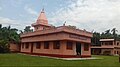 Located in Budhabare-6, Shree Krishna Pranami Mandir is an important religious site in and around the Budhabare area.
 -
 People gather to observe a street play on a Wednesday in the bazaar area of Budhabare. Street plays like this usually carry with them a social message, and this one is on "Domestic Violence Against Women."
 -
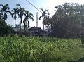 A village scene of Budhabare with maize plants and betelnut trees
 -
 Distant shot of Shree Buddha Adarsha Uccha Madhyamik Vidyalaya, the oldest educational institution in the village
 -
 Part of Mechi Highway that passes through the village of Budhabare


External links
References
- ^ a b "National Population and Housing Census 2011 (Nepal)" (PDF). cbs.gov.np. Central Bureau of Statistics, Nepal. Archived from the original (PDF) on 21 December 2016. Retrieved 1 June 2016.
- ^ Budhabare: Hijo ra Aaja (in Nepali) (First ed.). Village Development Committee, Budhabare.
- ^ a b c d e f "NEP: Third Small Towns Water Supply and Sanitation Sector Project – Budhabare, Jhapa District" (PDF). adb.org. Asian Development Bank. Retrieved 6 June 2016.
- ^ a b c Bimala Pandey. "Role of Remittance in Rural Poverty Reduction - A Case Study of Budhabare-9, Jhapa, Nepal" (PDF). Norwegian University of Life Sciences. Retrieved 4 June 2016.
- ^ "Co-ordinates of Budhabare, Mechi". maps.google.com. Google Maps. Retrieved 2 June 2016.
- ^ a b c "Climatic Data of Budhabare, Mechi". en.climate-data.org. Climate-data.org. Retrieved 1 June 2016.
- ^ a b c d e "National Population and Housing Census, 2011 (Jhapa)" (PDF). cbs.gov.np. Central Bureau of Statistics, Nepal. Archived from the original (PDF) on 18 July 2016. Retrieved 5 June 2016.
- ^ CIA (2011) The World Factbook : Nepal.

Financial Institution: NICASIA Bank Limited