
Bull Mountain (Garfield County, Utah)
| Bull Mountain | |
|---|---|
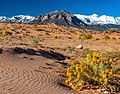
 Northeast aspect, from Highway 95 (Snow-capped Mt. Ellen in back} | |
| Highest point | |
| Elevation | 9,187 ft (2,800 m)[1] |
| Prominence | 1,347 ft (411 m)[1] |
| Isolation | 2.83 mi (4.55 km)[2] |
| Coordinates | 38°08′25″N 110°43′56″W / 38.1402626°N 110.7320964°W[3] |
| Geography | |
 Bull Mountain Location in Utah  Bull Mountain Bull Mountain (the United States) | |
| Location | class 2 scrambling[2] |
Bull Mountain is a 9,187-foot (2,800 m) elevation summit located in northern Garfield County of Utah, United States.[3] Bull Mountain is part of the Henry Mountains which are set between Capitol Reef National Park to the west, and Glen Canyon National Recreation Area to the east. Mount Ellen is immediately southwest of Bull Mountain, and Burr Desert spreads out to the northeast. It is situated in a dry, rugged, and sparsely settled region, set on primitive land administered by the Bureau of Land Management. Precipitation runoff from this mountain drains into tributaries of the Colorado River. The nearest town is Hanksville, 17 miles to the north, and Robbers Roost is 20 miles to the northeast.
Climate
Spring and fall are the most favorable seasons to visit Bull Mountain. According to the
Gallery
-
 South aspect
 -
 Northeast aspect
 -
 From the north


See also
References
- ^ a b "Bull Mountain". Peakbagger.com. Retrieved 2020-09-14.
- ^ a b "Bull Mountain - 9,187' UT". listsofjohn.com. Retrieved 2020-09-14.
- ^ a b "Bull Mountain". Geographic Names Information System. United States Geological Survey, United States Department of the Interior. Retrieved 2020-09-14.
External links
- Weather forecast: Bull Mountain