
Buren
Buren | |
|---|---|
Municipality | |
 Buren | |
|
UTC+2 (CEST) | |
| Postcode | Parts of 4000 and 4100 ranges |
| Area code | 0344, 0345 |
| Website | www |

Buren (Dutch pronunciation:
Geography
Buren is located in
in the south.Population centers
Population centers include:
History
The earliest known settlement of the region occurred as early as 772.
_-_A_winter_landscape_with_activities_on_the_ice_near_Castle_Buren.jpg)
The Castle eventually came into the possession of the
The current municipality is the result of 2 mergers. On 1 January 1978, the municipalities of Beusichem, Zoelen and part of Buurmalsen were added to the existing municipality of Buren, that was formed in the mid-19th century. On 1 January 1999, Buren was enlarged with the addition of the municipalities of Lienden and Maurik.

Historical sites
Buren has two museums:
- The Museum of the Royal Military Police, located in a 17th-century orphanage.[6]
- The Museum of the Dutch Royal Family, located in the historic city hall.[7]
It is also home to De Prins Van Oranje, a restored windmill.
Government and politics
The title "Count or Countess of Buren and Leerdam" is held by
Demographics
Twin town
Buren is twinned with:
Notable people
- Philip William, Prince of Orange (1554 in Buren – 1618) Prince of Orange in 1584 and Knight of the Golden Fleece in 1599
- Gerard de Kruijff (1890 in Buren – 1968) a Dutch horse rider who competed in the 1924 and the 1928 Summer Olympics
- Lukas Smits (born 1935 in Ravenswaaij) a Dutch painter.
- Jos Beijnen (born 1956 in Beusichem) a Dutch pharmacist and academic
- Ron Stevens (born 1959 in Lienden) a Dutch sprint canoer who competed in two Summer Olympics
Gallery
-
 The Culemborg gate with the Saint-Lambertus church, Buren in the background.
 -
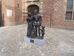 Statue in the center of Buren - William of Orange and Anna van Buren
 -
 Buren, panoramio
 -
 Buren, Herenstraat and the Rodeheldenstraat in the background.
 -
 Weighing scales and village pump on the market square in Buren.
 -
 Buren, church, de Sint-Lambertuskerk behind the wall
 -
 Buren, orphan house behind the wall


.jpg)

.jpg)


See also
References
- ^ "Samenstelling college" [Members of the board] (in Dutch). Gemeente Buren. Archived from the original on 14 July 2014. Retrieved 18 June 2014.
- ^ "Kerncijfers wijken en buurten 2020" [Key figures for neighbourhoods 2020]. StatLine (in Dutch). CBS. 24 July 2020. Retrieved 19 September 2020.
- ^ "Postcodetool for 4021VZ". Actueel Hoogtebestand Nederland (in Dutch). Het Waterschapshuis. Retrieved 18 June 2014.
- ^ "Bevolkingsontwikkeling; regio per maand" [Population growth; regions per month]. CBS Statline (in Dutch). CBS. 1 January 2021. Retrieved 2 January 2022.
- ISBN 90-400-9406-3
- ^ "Home - Marechausseemuseum". Marechausseemuseum.nl. Archived from the original on 13 November 2014. Retrieved 15 January 2017.
- ^ "Burenenoranje". burenenoranje.nl. Archived from the original on 18 February 2009. Retrieved 15 January 2017.
- ^ "Zorgatlas". www.zorgatlas.nl. Archived from the original on 5 December 2011. Retrieved 15 January 2017.
- ^ "Kinderhook to honor sister city". Times Union. Albany, N.Y.: Hearst Newspapers. July 21, 2018. Retrieved August 5, 2018.
External links
Places adjacent to Buren | |
|---|---|

| International | |
|---|---|
| National | |
| Geographic | |