
Carcar
Carcar | ||
|---|---|---|
| City of Carcar | ||
 Carcar Old Town Plaza as seen from the bell tower of St. Catherine of Alexandria Church | ||
 Seal | ||
| Nickname: Heritage City of the South | ||
| Motto(s): Sidlak Carcar!, Sadya Carcar! | ||
| Anthem: Ganghaan sa habagatan English: Southern gate | ||
 Map of Cebu with Carcar highlighted | ||
OpenStreetMap OpenStreetMap  | ||
.svg) Carcar Location within the Philippines | ||
| Coordinates: 10°07′N 123°38′E / 10.12°N 123.63°E | ||
| Country | Philippines | |
| Region | Central Visayas | |
| Province | Cebu | |
| District | 1st district | |
Founded | 1599 | |
| Cityhood | July 1, 2007 (Lost cityhood in 2008 and 2010) | |
| Affirmed Cityhood | February 15, 2011 | |
| Barangays | 15
(see Vice Mayor Efren A. Quijano (1Cebu) | |
| • Representative | Rhea Mae A. Gullas | |
| • City Council | Members | |
| • ZIP code | 6019 | |
| PSGC | ||
| IDD : area code | +63 (0)32 | |
| Native languages | Cebuano Tagalog | |
Carcar, officially the City of Carcar (Cebuano: Dakbayan sa Carcar; Filipino: Lungsod ng Carcar), is a component city in the province of Cebu, Philippines. According to the 2020 census, it has a population of 136,453 people.[3]
History
Carcar was known as "Kabkad" or "Sialo" before Spanish colonization.[citation needed] It became a town in 1599. Carcar is considered one of the oldest towns in Cebu, with its Spanish influence lasted more than 300 years ago.
World War II and the Koga papers
In early April 1944, fishermen Pedro Gantuangko and Rufo Wamar, both residents of Carcar, discovered a wooden box floating off the coast of San Fernando, Cebu after they were alerted to the crash of a Japanese plane at sea. Upon retrieving the box from the shore, they discovered a water-soaked portfolio containing various Japanese-language documents, which they dried for the next two days and kept hidden from Japanese authorities. Gantuangko eventually handed over the documents to local guerrillas, with the papers soon reaching Lt. Col. James M. Cushing. Japanese military officers murdered numerous civilians in their persistent search for the documents, with both Gantuangko and Wamar separately fleeing to Bohol to hide from authorities.[5][6]
The documents, later named the "Koga papers" after General Mineichi Koga, were picked up by the American submarine USS Crevalle in Negros Oriental and sent to Brisbane, Australia, where it was discovered by General Douglas MacArthur to contain plans called Operation Z that revealed the Japanese' tactics in the Pacific theatre. The papers soon proved crucial to the forming of the Allied plan to liberate the Philippines, pushing the planned Allied invasion of the country to October 1944, two months ahead of schedule.[5][6]
Cityhood
In July 2007, the municipality of Carcar was converted into a component city of the province of Cebu after ratification of Republic Act 9436.
On November 18, 2008, Supreme Court ruled that the cityhood charters of Carcar and 15 other cities as unconstitutional as a result of a petition filed by the League of Cities of the Philippines. A year later, on December 22, Carcar and 15 other municipalities regained their status as cities again after the court reversed its November 18, 2008, ruling. On August 23, 2010, the court reinstated its ruling on November 18, 2008, causing Carcar and 15 cities to revert to municipalities. Finally on February 15, 2011, Carcar and the other 15 municipalities regained their cityhood status.
In 2013, after a six year legal battle, the League of Cities of the Philippines acknowledged and recognized the cityhood of Carcar and 15 other cities on July 19, 2013.[7][8]
Geography
Carcar City is bordered to the north by the town of
Carcar lies on the southernmost part of Metro Cebu area.[9]
- Topography
The land is generally level with less than 18% slope comprising 78.7% of the total land area. Areas with slopes ranging from 18 to 50% cover 19.3% of the total land area and those over 50% slope comprise approximately 1.9%. The highest recorded elevation is a little over 660 metres (2,170 ft) above sea level, located within the barangay of Napo.
- Soil type
The municipality has five dominant soil types namely: Faraon Clay, Steep Phase, the Lugo Clay, the Mandaue clay loam & the Hydrosol type.
Barangays
Carcar is politically subdivided into 15 barangays. Each barangay consists of
| PSGC | Barangay | Population | ±% p.a. | |||
|---|---|---|---|---|---|---|
| 2020[3] | 2010[10] | |||||
| 072214001 | Bolinawan | 8.0% | 10,881 | 10,852 | 0.03% | |
| 072214002 | Buenavista | 2.0% | 2,662 | 2,294 | 1.50% | |
| 072214003 | Calidngan | 2.4% | 3,258 | 2,953 | 0.99% | |
| 072214004 | Can‑asujan | 6.7% | 9,114 | 7,845 | 1.51% | |
| 072214005 | Guadalupe | 9.3% | 12,641 | 10,633 | 1.74% | |
| 072214006 | Liburon | 5.6% | 7,606 | 6,749 | 1.20% | |
| 072214007 | Napo | 4.7% | 6,427 | 6,344 | 0.13% | |
| 072214008 | Ocaña | 6.9% | 9,361 | 8,507 | 0.96% | |
| 072214009 | Perrelos | 10.4% | 14,129 | 12,901 | 0.91% | |
| 072214012 | Poblacion I | 8.0% | 10,919 | 8,996 | 1.96% | |
| 072214013 | Poblacion II | 2.0% | 2,680 | 2,432 | 0.98% | |
| 072214014 | Poblacion III | 5.1% | 6,898 | 5,763 | 1.81% | |
| 072214015 | Tuyom | 4.5% | 6,080 | 5,563 | 0.89% | |
| 072214010 | Valencia | 4.0% | 5,485 | 4,885 | 1.17% | |
| 072214011 | Valladolid | 8.4% | 11,523 | 10,606 | 0.83% | |
| Total | 136,453 | 107,323 | 2.43% | |||
Climate
The wet season occurs during the months of May to October and the dry season, from January to May.
| Climate data for Carcar, Cebu | |||||||||||||
|---|---|---|---|---|---|---|---|---|---|---|---|---|---|
| Month | Jan | Feb | Mar | Apr | May | Jun | Jul | Aug | Sep | Oct | Nov | Dec | Year |
| Mean daily maximum °C (°F) | 28 (82) |
29 (84) |
30 (86) |
31 (88) |
31 (88) |
30 (86) |
30 (86) |
30 (86) |
30 (86) |
29 (84) |
29 (84) |
28 (82) |
30 (85) |
| Mean daily minimum °C (°F) | 23 (73) |
23 (73) |
23 (73) |
24 (75) |
25 (77) |
25 (77) |
25 (77) |
25 (77) |
25 (77) |
25 (77) |
24 (75) |
23 (73) |
24 (75) |
| Average precipitation mm (inches) | 70 (2.8) |
49 (1.9) |
62 (2.4) |
78 (3.1) |
138 (5.4) |
201 (7.9) |
192 (7.6) |
185 (7.3) |
192 (7.6) |
205 (8.1) |
156 (6.1) |
111 (4.4) |
1,639 (64.6) |
| Average rainy days | 13.4 | 10.6 | 13.1 | 14.5 | 24.2 | 27.9 | 28.4 | 27.7 | 27.1 | 27.4 | 22.5 | 15.9 | 252.7 |
| Source: Meteoblue (Use with caution: this is modeled/calculated data, not measured locally.)[11] | |||||||||||||
Demographics
| Year | Pop. | ±% p.a. |
|---|---|---|
| 1903 | 31,895 | — |
| 1918 | 37,392 | +1.07% |
| 1939 | 36,308 | −0.14% |
| 1948 | 32,818 | −1.12% |
| 1960 | 36,304 | +0.84% |
| 1970 | 45,806 | +2.35% |
| 1975 | 47,174 | +0.59% |
| 1980 | 57,822 | +4.15% |
| 1990 | 70,841 | +2.05% |
| 1995 | 78,726 | +2.00% |
| 2000 | 89,199 | +2.71% |
| 2007 | 100,632 | +1.68% |
| 2010 | 107,323 | +2.37% |
| 2015 | 119,664 | +2.09% |
| 2020 | 136,453 | +2.62% |
| Source: Philippine Statistics Authority[12][10][13][14] | ||
Economy
Poverty incidence of Carcar
10
20
30
40
50
2000
49.90 2003
22.88 2006
35.00 2009
27.21 2012
17.02 2015
21.39 2018
13.80 2021
30.71 Source: Philippine Statistics Authority[15][16][17][18][19][20][21][22] |
Tourism

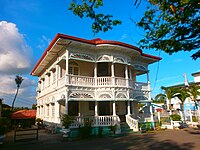
- As a heritage city of Cebu, Carcar contains various Spanish and American period structures. The Carcar plaza alone hosts several heritage structures, the Church of St. Catherine of Alexandria dominates the area. Within the complex various structures stand, including quaint houses and their distinctive architectural details.
- Surrounding the Rotunda and in the public market one will find the famous Carcar puso– just some of the local delicacies.
- Guadalupe Mabugnao Mainit Hot Spring National Park
- Heritage Houses such as the Mercado Mansion
- Tuyom Beach – Beach Houses
- The Kabkaban Festival, which is the town's local festival in honor of St. Catherine of Alexandria. The name of the festival comes from the old name of the town, which was taken from the local term for the Oakleaf Fern (Aglaomorpha quercifolia) which is abundant in the town, even to this day. Celebrated from the November 23 to 25, it highlights the rich culture, faith, and musical history of Carcar.
Education
The public schools in Carcar are administered by the Schools Division of Carcar City.
Elementary schools
- Bolinawan Elementary School — Bolinawan
- Buenavista Elementary School — Buenavista
- Calidngan Elementary School — Calidngan
- Canal Elementary School — Sitio Canal, Bolinawan
- Can-asujan Elementary School — Can-asujan
- Cara-atan Elementary School — Sitio Cara-atan, Buenavista
- Carcar Central Elementary School — P. Nellas Street, Poblacion III
- Guadalupe Elementary School — Guadalupe
- Hunob Elementary School — Sitio Hunob, Guadalupe
- Kalangyawon Elementary School — Sitio Kalangyawon, Napo
- Kamanggahan Elementary School — Sitio Kamanggahan, Guadalupe
- Kayam Elementary School — Sitio Kayam, Napo
- Liburon Elementary School — Liburon
- Lunas Elementary School — Sitio Lunas, Calidngan
- Mainit Elementary School — Sitio Mainit, Guadalupe
- Manghupi Elementary School — Sitio Manghupi, Can-asujan
- Maximina V. Barangan Elementary School — Poblacion I
- Moag Elementary School — Sitio Moag, Guadalupe
- Napo Elementary School — Napo
- Ocaña Central Elementary School — Ocaña
- Perrelos Elementary School — Perrelos
- Pit-os Elementary School — Sitio Pit-os, Calidngan
- Sa-ay Elementary School — Sitio Saay, Can-asujan
- Tagaytay Elementary School — Sitio Tagaytay, Can-asujan
- Tal-ot Elementary School — Sitio Tal-ut, Valencia
- Tapal Elementary School — Sitio Tapal, Guadalupe
- Tawog Elementary School — Sitio Tawog, Valladolid
- Tuyom Elementary School — Tuyom
- Upland Elementary School — Poblacion I
- Valencia Elementary School — Valencia
- Valladolid Elementary School — Valladolid
High schools
- Can-asujan National High School — Can-asujan
- Carcar Central National High School — P. Nellas Street, Poblacion III
- Gelacio C. Babao, Sr. Memorial National High School — Valladolid
- Kalangyawon National High School — Sitio Kalangyawon, Napo
- Liburon National High School — Liburon
- Maximino Noel Memorial National High School — Guadalupe
- Ocaña National High School — Ocaña
- Perrelos National High School — Perrelos
- Pit-os National High School — Sitio Pit-os, Calidngan
- Roberto E. Sato Memorial National High School — Calidngan
- Tal-ut National High School — Sitio Tal-ut, Valencia
- Tuyom National High School — Tuyom
- Tuyom Senior High School — Tuyom
- Valencia National Vocational High School — Valencia
Integrated schools
- Puesto Integrated School — Sitio Puesto, Napo
- Sacsac Integrated School — Sacsac, Calidngan, Carcar City
Colleges
- Carcar City College — P. Vasquez St., Poblacion I
Notable personalities
- Teofilo Camomot – founded the Congregation of Blessed Virgin Missionaries
- Sheryn Regis – singer
Gallery
-
 Rizal Monument at Old Town Plaza
 -
 Carcar City Museum (formerly, Carcar Dispensary)
 -
 St. Catherine of Alexandria Church Interior
 -
 Carcar Former Municipal Complex


References
- (DILG)
- (PDF) from the original on May 25, 2021. Retrieved July 16, 2021.
- ^ a b c Census of Population (2020). "Region VII (Central Visayas)". Total Population by Province, City, Municipality and Barangay. Philippine Statistics Authority. Retrieved July 8, 2021.
- ^ "PSA Releases the 2021 City and Municipal Level Poverty Estimates". Philippine Statistics Authority. April 2, 2024. Retrieved April 28, 2024.
- ^ a b National Historical Commission of the Philippines (April 3, 2025). "On this day, 81 years ago[...]". Facebook. Meta Platforms, Inc. Retrieved April 4, 2025.
[...]Filipino fishermen Pedro Gantuangko and Rufu Wamar, discovered a strange box floating off the coast of Magtalisay, San Fernando, Cebu.
- ^ University of Hawaii: 127–130. Retrieved April 4, 2025.
Before the discovery of the documents the Americans planned to retake the Philippines by landing first at Sarangani Bay, Cotabato[...] in late December 20, 1944.
- ^ "16 new cities recognized as LCP members (Archived)". Sun Star News. July 19, 2013. Retrieved March 6, 2018.
- ^ "League finally recognizes 16 'unqualified' cities". Rappler. July 19, 2013. Retrieved March 6, 2018.
- ^ Sun–Star 2005.
- ^ a b Census of Population and Housing (2010). "Region VII (Central Visayas)" (PDF). Total Population by Province, City, Municipality and Barangay. National Statistics Office. Retrieved June 29, 2016.
- ^ "Carcar: Average Temperatures and Rainfall". Meteoblue. Retrieved May 10, 2020.
- ^ Census of Population (2015). "Region VII (Central Visayas)". Total Population by Province, City, Municipality and Barangay. Philippine Statistics Authority. Retrieved June 20, 2016.
- ^ Censuses of Population (1903–2007). "Region VII (Central Visayas)". Table 1. Population Enumerated in Various Censuses by Province/Highly Urbanized City: 1903 to 2007. National Statistics Office.
- ^
"Province of Cebu". Municipality Population Data. Local Water Utilities AdministrationResearch Division. Retrieved December 17, 2016.
- ^ "Poverty incidence (PI):". Philippine Statistics Authority. Retrieved December 28, 2020.
- ^ "Estimation of Local Poverty in the Philippines" (PDF). Philippine Statistics Authority. November 29, 2005.
- ^ "2003 City and Municipal Level Poverty Estimates" (PDF). Philippine Statistics Authority. March 23, 2009.
- ^ "City and Municipal Level Poverty Estimates; 2006 and 2009" (PDF). Philippine Statistics Authority. August 3, 2012.
- ^ "2012 Municipal and City Level Poverty Estimates" (PDF). Philippine Statistics Authority. May 31, 2016.
- ^ "Municipal and City Level Small Area Poverty Estimates; 2009, 2012 and 2015". Philippine Statistics Authority. July 10, 2019.
- ^ "PSA Releases the 2018 Municipal and City Level Poverty Estimates". Philippine Statistics Authority. December 15, 2021. Retrieved January 22, 2022.
- ^ "PSA Releases the 2021 City and Municipal Level Poverty Estimates". Philippine Statistics Authority. April 2, 2024. Retrieved April 28, 2024.
Sources
- Sun–Star (October 8, 2005). "RDC enlarges Metro Cebu". Archived from the original on September 30, 2007. Retrieved November 10, 2015.
External links
 Media related to Carcar at Wikimedia Commons
 Carcar travel guide from Wikivoyage
- Philippine Standard Geographic Code
Places adjacent to Carcar | ||||||||||||||||
|---|---|---|---|---|---|---|---|---|---|---|---|---|---|---|---|---|
| ||||||||||||||||

| International | |
|---|---|
| National | |