
Crosswicks, New Jersey
Crosswicks, New Jersey | |
|---|---|
 The J. Ivins House on Church Street, part of the Crosswicks Historic District | |
 Crosswicks Location of Crosswicks in Burlington County (Inset: Location of county within the state of New Jersey)  Crosswicks Crosswicks (New Jersey)  Crosswicks Crosswicks (the United States) | |
| Coordinates: 40°09′12″N 74°38′52″W / 40.15333°N 74.64778°W | |
| Country | |
| State | |
| County | Burlington |
| Township | Chesterfield |
| Area | |
| • Total | 1.84 sq mi (4.78 km2) |
| • Land | 1.82 sq mi (4.73 km2) |
| • Water | 0.02 sq mi (0.05 km2) |
| Elevation | 82 ft (25 m) |
| Population | |
| • Total | 849 |
| • Density | 465.21/sq mi (179.63/km2) |
| Time zone | UTC−05:00 (Eastern (EST)) |
| • Summer (DST) | UTC−04:00 (EDT) |
| Area code(s) | 609, 640 |
| FIPS code | 34-16060[4] |
| GNIS feature ID | 875749[2] |
Crosswicks is an unincorporated community and census-designated place (CDP)[5] located along the Crosswicks Creek in the northern part of Chesterfield Township in Burlington County in the U.S. state of New Jersey.[6][7] The area is served as United States Postal Service ZIP Code 08515.
As of the 2000 United States census, the population for ZIP Code Tabulation Area 08515 was 290.
History
Chesterfield Township comprises three distinct communities: Chesterfield, Crosswicks and Sykesville. The area was first settled in 1677, when a group primarily consisting of
On June 23, 1778, during the
Crosswicks is home to a
The Crosswicks Community Association holds an annual family-style croquet tournament and music festival on the village green in July. There is live music provided by local bands during the day. Food is available from vendors. There are lawn games set up for children.
Historic district
Crosswicks Historic District | |
 J. M. Bunting House, built c. 1858 | |
| Location | Chesterfield-Crosswicks Road, Main, Church and Front Streets |
|---|---|
| Area | 50 acres (20 ha) |
| Architectural style | Greek Revival, Gothic, Provincial Georgian |
| NRHP reference No. | 76001146[11] |
| NJRHP No. | 777[12] |
| Significant dates | |
| Added to NRHP | May 3, 1976 |
| Designated NJRHP | October 23, 1975 |
The Crosswicks Historic District is a 50-acre (20 ha)
-
 Crosswicks Friends Meeting House, built 1773
 -
 Friends First Day School, built c. 1784
 -
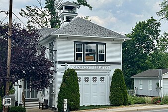 Crosswicks Public Library, built 1922
 -
 Crosswicks Community House, built 1923


Geography
The community has an area of 51.98 square kilometres (20.07 sq mi) and is located on the bank of Crosswicks Creek, a tributary of the Delaware River. The community is located 9.1 kilometres (5.7 mi) from Trenton, the capital of the U.S state of New Jersey and 27 kilometres (17 mi) from Philadelphia.
Demographics
As of the 2020 United States census, the population was 849.[3]
| Census | Pop. | Note | %± |
|---|---|---|---|
| 2020 | 849 | — | |
| U.S. Decennial Census[16] 2020[3] | |||
See also
- National Register of Historic Places listings in Burlington County, New Jersey
- List of Friends meeting houses
References
- ^ "ArcGIS REST Services Directory". United States Census Bureau. Retrieved October 11, 2022.
- ^ a b "Crosswicks". Geographic Names Information System. United States Geological Survey, United States Department of the Interior. Variant name: Crossweeksung
- ^ a b c Census Data Explorer: Crosswicks CDP, New Jersey, United States Census Bureau. Accessed June 15, 2023.
- ^ Geographic Codes Lookup for New Jersey, Missouri Census Data Center. Accessed June 9, 2023.
- ^ State of New Jersey Census Designated Places - BVP20 - Data as of January 1, 2020, United States Census Bureau. Accessed December 1, 2022.
- ^ Genovese, Peter (September 27, 2019). "N.J.'s 33 best small towns, ranked, for the ultimate fall day trip". NJ.com. Retrieved February 18, 2020.
- ^ Locality Search, State of New Jersey. Accessed March 15, 2015.
- ^ History of Chesterfield Township, Chesterfield Township. Accessed March 6, 2007. Archived October 11, 2007, at the Wayback Machine
- ^ Hutchinson, Viola L. (May 1945). The Origin of New Jersey Place Names (PDF). New Jersey Public Library Commission. p. 11.
- ^ Zimmerman, Colin (August 4, 2022). "The Battle of Crosswicks: Prelude to Monmouth".
- ^ "National Register Information System – (#76001146)". National Register of Historic Places. National Park Service. November 2, 2013.
- ^ "New Jersey and National Registers of Historic Places – Burlington County" (PDF). New Jersey Department of Environmental Protection – Historic Preservation Office. September 29, 2022. p. 5.
listed as the Crosswicks Historic District
- ^ a b Dr. and Mrs. John J. Winters, Jr. (October 1975). "National Register of Historic Places Inventory/Nomination: Crosswicks". National Park Service. With accompanying 31 photos
- Historic American Buildings Survey. 1936.
- ^ "A Brief History of the Crosswicks Friends Meeting". Crosswicks Friends Meeting.
- ^ "Census of Population and Housing". Census.gov. Retrieved June 4, 2016.
External links
 Media related to Crosswicks, New Jersey at Wikimedia Commons
- Historic American Buildings Survey (HABS) No. NJ-25, "Chesterfield Friends Meeting House, Front & Church Streets, Crosswicks, Burlington County, NJ", 8 photos, 12 measured drawings, 4 data pages
- Census 2000 Fact Sheet for ZIP Code Tabulation Area 08515 from the United States Census Bureau
- Crosswicks Fire Department

| International | |
|---|---|
| National | |