
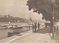
Danube Promenade
Erzsébet Bridge, Széchenyi Chain Bridge, Gellért Hill
.47°29′44″N 19°2′55″E / 47.49556°N 19.04861°E The Danube Promenade (
Erzsébet Bridge
.
History
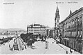
From the middle of the 19th century the city center has developed rather fast. On the left bank of the Danube a row of hotels began to rise. These were the Hungária, Bristol (Duna Szálló), Carlton, and Ritz (Duna palota). Among them only Bristol survived the destruction of World War II, but in 1969 the hotel was demolished. In front of the hotels an esplanade took shape that later became known as Dunakorzó (En: Danube Boardwalk).
Along the esplanade
The southern end of the promenade is the
Contra-Aquincum, are displayed, The Inner City Parish Church’s simple exterior conceals a colorful past: it was built as a Romanesque basilica and later was used as a mosque during the Turkish occupation and was finally reconceived in the baroque
style in the 18th century.
The center of the promenade is the
Vigadó Concert Hall
.
At the other end of the street can be found
Gresham-palota and the Hungarian Academy of Sciences
.
Important buildings and landmarks around the promenade
- Contra-Aquincum, a 4th century Roman fortress next to Erzsébet Bridge
- Inner City Parish Church
- Vigadó Concert Hall
- Gresham-palota
- Hungarian Academy of Sciences next to Széchenyi Chain Bridge
Sculptures
- István Széchenyi - near to the Hungarian Academy of Sciences
- József Eötvös - 1879 sculptor Huszár Adolf
- Hungarian Seaman Memorial - the anchor of "Ungvár" (copy) - Szende Pál utca
- József Nádor Archduke Joseph, Palatine of Hungary
- Vigadó Concert Hall - Also in Marton László sculptors garden NaphegyTigris utca, with other works.
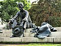
- Attila József - famous poet of "At the Danube" also by László Marton (sculptor) at Hungarian Parliament Building
- Mihály Vörösmarty
- William Shakespeare
- Petőfi Sándor
- Shoes on the Danube Promenade Gyula Pauer and Can Togay- April 16. 2005.
Gallery


- Pictures of the promenade from the 1910s.
-
 The promenade with people having a walk
 -
 Petőfi Sándor Square
 -
 The promenade
 -
 Grand Hotel Hungária


- Some important monuments
-
 The Little Princess
 -

-
 The statue of Attila József


See also
- Naphegy
- Shoes on the Danube Promenade
- Tabán
- World Heritage Site
Sources
- Budapest Info
- www.visitbudapest.travel
- www.welovebudapest.com Archived 2019-08-16 at the Wayback Machine
References
- ^ "kiskirálylány 2". 27 September 2007. Archived from the original on 2007-09-27.
External links
- Google search "Danube Promenade"
- Google search "Dunakorzó" (Hungarian name)
- Walking Tour 1: Pest's Inner City [permanent dead link]
Maps
- Google Map from Erzsébet Bridge
- Near view to Vigadó Tér and Vörösmarty tér on Google Map
- Danube Promenade on the old Map from 1905.
- 1905, the last years of Austria-Hungary.