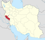
Dehloran County
Dehloran County
UTC+3:30 (IRST) | |
|---|---|
| Dehloran County can be found at GEOnet Names Server, at this link, by opening the Advanced Search box, entering "9205933" in the "Unique Feature Id" form, and clicking on "Search Database". |
Dehloran County (Persian: شهرستان دهلران) is in Ilam province, Iran. Its capital is the city of Dehloran.
At the 2006 census, the county's population was 58,993 in 11,376 households.[3] The following census in 2011 counted 66,399 people in 14,852 households.[4] At the 2016 census, the county's population was 65,630 in 16,959 households.[2]
Dehloran County is mostly populated by the Kurdish Kurdali tribe and has an Arab and Lur minority.[5]
Administrative divisions
The population history and structural changes of Dehloran County's administrative divisions over three consecutive censuses are shown in the following table. The latest census shows four districts, eight rural districts, and four cities.[2]
In March 2017, Abu Ghoveyr and Dasht-e Abbas Rural Districts were transferred from Musian District in the establishment of Dasht-e Abbas District. At the same time, Dalpari Rural District was established in Musian District.[6]
| Administrative Divisions | 2006[3] | 2011[4] | 2016[2] |
|---|---|---|---|
| Central District | 32,311 | 36,942 | 38,304 |
| Anaran RD | 4,709 | 5,953 | 5,363 |
| Dehloran (city) | 27,602 | 30,989 | 32,941 |
| Dasht-e Abbas District1 | |||
| Abu Ghoveyr RD | |||
| Dasht-e Abbas RD | |||
| Musian District | 16,275 | 19,427 | 18,282 |
| Abu Ghoveyr RD | 1,142 | 1,915 | 1,813 |
| Dalpari RD1 | |||
| Dasht-e Abbas RD | 8,525 | 9,782 | 9,204 |
| Nahr-e Anbar RD | 4,037 | 5,153 | 4,806 |
| Musian (city) | 2,571 | 2,577 | 2,459 |
| Sarab Meymeh District | 2,766 | ||
| Gurab RD | 626 | ||
| Takhtan RD | 227 | ||
| Meymeh (city) | 1,913 | ||
| Zarrinabad District | 10,407 | 10,030 | 6,227 |
| Seyyed Ebrahim RD | 1,547 | 1,350 | 1,114 |
| Seyyed Nasereddin RD | 2,242 | 1,979 | 1,243 |
| Meymeh (city) | 2,277 | 2,636 | |
| Pahleh (city) | 4,341 | 4,065 | 3,870 |
| Total | 58,993 | 66,399 | 65,630 |
| RD: Rural District 1Established after the 2016 census[6] | |||
References
- ^ OpenStreetMap contributors (28 March 2024). "Dehloran County" (Map). OpenStreetMap. Retrieved 28 March 2024.
- ^ a b c d "Census of the Islamic Republic of Iran, 1395 (2016)". AMAR (in Persian). The Statistical Center of Iran. p. 16. Archived from the original (Excel) on 1 November 2020. Retrieved 19 December 2022.
- ^ a b "Census of the Islamic Republic of Iran, 1385 (2006)". AMAR (in Persian). The Statistical Center of Iran. p. 16. Archived from the original (Excel) on 20 September 2011. Retrieved 25 September 2022.
- ^ a b "Census of the Islamic Republic of Iran, 1390 (2011)". Syracuse University (in Persian). The Statistical Center of Iran. p. 16. Archived from the original (Excel) on 17 January 2023. Retrieved 19 December 2022.
- ^ Fattah, Ismaïl Kamandâr (2000), Les dialectes kurdes méridionaux, Acta Iranica 37, p. 32
- ^ a b Jahangiri, Ishaq (22 March 2017). "Approval letter regarding country divisions in Dehloran County, Ilam province". Islamic Parliament Research Center of the Islamic Republic of Iran (in Persian). Ministry of Interior, Council of Ministers. Archived from the original on 13 March 2019. Retrieved 5 June 2023.

