Effects of Hurricane Georges in Louisiana
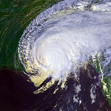
 Hurricane Georges making landfall in Mississippi | |
| Tropical storm | |
|---|---|
| 1-minute sustained (SSHWS/NWS) | |
| Highest winds | 70 mph (110 km/h) |
| Lowest pressure | 970 mbar (hPa); 28.64 inHg |
| Overall effects | |
| Fatalities | 3 indirect |
| Damage | $30.1 million (1998 USD) |
| Areas affected | Southeast Louisiana |
Part of the 1998 Atlantic hurricane season | |
| History
Effects
Other wikis | |
The effects of Hurricane Georges in Louisiana included $30.1 million in damage and three deaths. Forming from a
Numerous homes located outside the
Background

Tropical storm (39–73 mph, 63–118 km/h)
Category 1 (74–95 mph, 119–153 km/h)
Category 2 (96–110 mph, 154–177 km/h)
Category 3 (111–129 mph, 178–208 km/h)
Category 4 (130–156 mph, 209–251 km/h)
Category 5 (≥157 mph, ≥252 km/h)
Unknown
Hurricane Georges began as a
Over the following five days, the hurricane tracked through the
Preparations
At 9:00 am

During September 25–26, large-scale evacuations took place in response to forecasts suggesting a landfall near
Approximately 500,000 people evacuated from
Impact
Compared to the record-breaking rainfall in Mississippi, Alabama, and Florida, Hurricane Georges produced relatively little precipitation in Louisiana, peaking at 2.98 inches (76 mm) in Bogalusa.[2] The worst damages were confined to the southeastern portion of the state, concentrated in the Plaquemines and St. Bernard Parishes. A storm surge of 8.9 ft (2.7 m) was recorded in Gardene Bay before power at the recording station failed. Gale-force winds impacted most of the parish and gusts peaked at 82 mph (132 km/h). The combination of high winds and surge cut power to most of the area and flooded at least 50 homes, all of which were located outside the levee system.[3] A lighthouse on one island was partially submerged in the Gulf of Mexico, nearly 1,200 feet (370 m) from land following severe beach erosion. Six-foot (1.8 m) sand dunes on the islands were completely eroded by the storm, leaving boardwalks formerly situated atop the dunes suspended near the water's surface.[7]
In
Aftermath

Before Hurricane Georges, FEMA issued disaster declarations for Ascension, Assumption, Jefferson, Lafourche, Livingston, Plaquemines, Orleans, St. Bernard, St. Charles, St. James, St. John the Baptist, St. Tammany, Terrebone, Tangipahoa, and Washington Parishes. The declaration allowed residents to receive individual and public assistance.[8] Including relief funds to Puerto Rico and Mississippi associated with Georges, a total of $14,150,532 insurance claims was paid for by FEMA.[9] The Clinton administration appropriated $56 million in post-disaster funds for regions impacted Tropical Storm Frances and Hurricane Georges in Louisiana.[10]
Throughout the state, officials opened 67 shelters and deployed 1,200 FEMA personnel to Louisiana, Mississippi, Alabama, Florida and Georgia.
See also
References
- ^ a b Jerry Schwartz (September 28, 1998). "Hurricane Georges Slams Into Gulf Coast (News)". Associated Press. Archived from the original on October 25, 2012. Retrieved May 17, 2009.
- ^ a b c d John L. Guiney (January 5, 1999). "Hurricane Georges Tropical Cyclone Report". National Hurricane Center. Archived from the original on September 1, 2010. Retrieved April 22, 2009.
- ^ a b c d e "NCDC Event Report: Louisiana Hurricane". National Climatic Data Center. 1999. Archived from the original on January 26, 2012. Retrieved April 22, 2009.
- ^ "Hurricane Georges forces evacuation". The Minnesota Daily. Minneapolis, Minnesota. Associated Press. September 28, 1998. Archived from the original on April 17, 2021. Retrieved April 17, 2021.
- ^ Mary Dejevsky (September 28, 1998). "Georges heads for New Orleans". The Independent. Archived from the original on October 26, 2012. Retrieved April 22, 2009.
- ^ "Hurricane Georges heading toward Big Easy". Associated Press. September 27, 1998. Archived from the original on October 25, 2012. Retrieved May 17, 2009.
- ^ "Hurricane Georges Damages Chandeleur Islands—New Orleans' First Line Of Storm Defense". ScienceDaily. United States Geological Survey. October 5, 1998. Retrieved April 17, 2021.
- ^ Government of the United States (September 23, 1998). "Designated Counties for Louisiana Tropical Storm Frances and Hurricane Georges". Federal Emergency Management Agency. Archived from the original on May 8, 2009. Retrieved April 22, 2009.
- ^ Government of the United States (March 7, 2008). "Significant Flood Events". Federal Emergency Management Agency. Archived from the original on July 10, 2011. Retrieved April 22, 2009.
- ^ Government of the United States (October 2000). "Accomplishments of the Clinton-Gore Administration". Government of the United States. Archived from the original on February 18, 2013. Retrieved April 22, 2009.
- ^ "Recovering From Georges' Fury". CBS News. September 29, 1998. Archived from the original on April 17, 2021. Retrieved April 17, 2021.
- ^ "Hurricane Georges blasts Gulf Coast with rain, wind". The Winona Daily News. Winona, Minnesota. Associated Press. September 29, 1998. p. 1. Retrieved April 17, 2021 – via Newspapers.com.
- ^ "National Guard mobilized to help with aftermath of Hurricane Georges". Associated Press. September 29, 1998. Archived from the original on October 25, 2012. Retrieved May 17, 2009.
- ^ "UMCOR: Hurricane Georges News, October 2, 1998". United Methodist Committee on Relief. October 2, 1998. Archived from the original on September 19, 2008. Retrieved May 19, 2009.
- ^ Kyle Donaldson (August 12, 2008). "Documenting the Aftermath of Hurricane Georges". United States Geological Survey. Archived from the original on May 7, 2009. Retrieved May 19, 2009.
External links
- Tropical Cyclone Report from the National Hurricane Center
- Event report from the National Climatic Data Center


