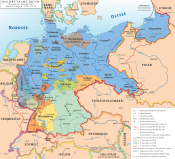
Free State of Anhalt
| Free State of Anhalt Freistaat Anhalt | |||||||||
|---|---|---|---|---|---|---|---|---|---|
| State of Germany | |||||||||
| 1918–1945 | |||||||||
Anthem | |||||||||
| Anhaltlied "Song of Anhalt" | |||||||||
| Capital | Dessau | ||||||||
| Area | |||||||||
| • Coordinates | 51°50′N 12°15′E / 51.833°N 12.250°E | ||||||||
• 1925 | 2,314 km2 (893 sq mi) | ||||||||
| Population | |||||||||
• 1925 | 351,045 | ||||||||
| Government | |||||||||
| • Type | Wilhelm Loeper | ||||||||
• 1935–1937 | Fritz Sauckel | ||||||||
• 1937–1945 | Rudolf Jordan | ||||||||
Minister-President | |||||||||
• 1918–1919 | Wolfgang Heine (first) | ||||||||
• 1919–1924 | Heinrich Deist | ||||||||
• 1924–1924 | Willy Knorr | ||||||||
• 1924–1932 | Heinrich Deist | ||||||||
• 1932–1940 | Alfred Freyberg | ||||||||
• 1940–1945 | Rudolf Jordan (last) | ||||||||
| Historical era | Interwar / World War II | ||||||||
• Established | 12 November 1918 | ||||||||
• Disestablished | 23 July 1945 | ||||||||
| |||||||||
The Free State of Anhalt (
Social-Democratic Party of Germany
(SPD).
However, in May 1932, the
Nazi seizure of power at the Reich level in 1933, Anhalt, along with all other German states, had its Landtag abolished and its state sovereignty transferred to the Reich government by the "Law on the Reconstruction of the Reich" of 30 January 1934. Though the state itself was not formally abolished, it was superseded in administrative importance by the Nazi Party Gau Magdeburg-Anhalt
.
At the end of World War II, when Germany was divided into
reunification of Germany
.
See also
References

External links
- (in German) More statistical information
- (in German) Further historical details


