
Freeport, Maine
Freeport, Maine | ||
|---|---|---|
 View of downtown | ||
|
FIPS code 23-26525 | | |
| GNIS feature ID | 0582481 | |
| Website | www | |
Freeport is a
Freeport is part of the
History
The town was once a part of North Yarmouth called Harraseeket, after the Harraseeket River. First settled about 1700, it was set off and incorporated on February 14, 1789 as Freeport. It is probably named "from the openness of its harbor" (free from ice).[3] Freeport developed as four villages—Mast Landing, Porter's Landing, South Freeport and Freeport Corner—all of which are now part of the Harraseeket Historic District, listed on the National Register of Historic Places.
At the
cars. The hotel burned in 1914, but its tower still stands.Freeport Corner was an inland village for farming and
In 1912,
In 1982,
-
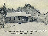 Old Ledge Schoolhouse c. 1905
 -
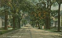 Main Street c. 1910
 -
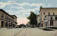 Main Street c. 1912
 -
 Jameson Tavern c. 1915
 -
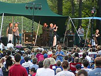 Rockapella performs at the L.L. Bean Summer Concert Series, July 2003
 -
 Facade of McDonald's located in Freeport where the restaurant was forced to maintain the pre-existing exterior of the house.
 -
 Main Street, 2012


Geography
According to the United States Census Bureau, the town has a total area of 46.47 square miles (120.36 km2), of which 34.70 square miles (89.87 km2) is land and 11.77 square miles (30.48 km2) is water.[1] Situated at the northeastern extremity of Casco Bay, Freeport is drained by the Harraseeket River.
Freeport borders Brunswick and Durham to the north, Pownal to the west, and Yarmouth to the southwest. Freeport also shares small borders with Cumberland and Harpswell in Casco Bay. Cumberland and Harpswell are not connected to Freeport by roads, but since Freeport's town border ranges out into Casco Bay, the other towns' borders meet Freeport's.
Climate
This
Transportation
Both U.S. 1 and Interstate-295 run directly through Freeport, the latter with three exits northbound (20, 22 and 24) and two exits southbound (22 and 20).
Amtrak's Downeaster train service stops at Freeport station with service to the Portland Transportation Center and Boston's North Station.
Demographics
| Census | Pop. | Note | %± |
|---|---|---|---|
| 1790 | 1,320 | — | |
| 1800 | 2,237 | 69.5% | |
| 1810 | 2,184 | −2.4% | |
| 1820 | 2,184 | 0.0% | |
| 1830 | 2,623 | 20.1% | |
| 1840 | 2,662 | 1.5% | |
| 1850 | 2,629 | −1.2% | |
| 1860 | 2,792 | 6.2% | |
| 1870 | 2,457 | −12.0% | |
| 1880 | 2,279 | −7.2% | |
| 1890 | 2,482 | 8.9% | |
| 1900 | 2,339 | −5.8% | |
| 1910 | 2,460 | 5.2% | |
| 1920 | 2,488 | 1.1% | |
| 1930 | 2,184 | −12.2% | |
| 1940 | 2,764 | 26.6% | |
| 1950 | 3,280 | 18.7% | |
| 1960 | 4,055 | 23.6% | |
| 1970 | 4,781 | 17.9% | |
| 1980 | 5,863 | 22.6% | |
| 1990 | 6,905 | 17.8% | |
| 2000 | 7,800 | 13.0% | |
| 2010 | 7,879 | 1.0% | |
| 2020 | 8,737 | 10.9% | |
| U.S. Decennial Census[10] | |||
2010 census
As of the
There were 3,209 households, of which 32.6% had children under the age of 18 living with them, 55.8% were married couples living together, 8.2% had a female householder with no husband present, 3.7% had a male householder with no wife present, and 32.3% were non-families. Of all households, 25.1% were made up of individuals, and 10% had someone living alone who was 65 years of age or older. The average household size was 2.40 and the average family size was 2.89.
The median age in the town was 45 years. 22.8% of residents were under the age of 18; 5.3% were between the ages of 18 and 24; 22% were from 25 to 44; 34.7% were from 45 to 64; and 15.3% were 65 years of age or older. The gender makeup of the town was 47.4% male and 52.6% female.
2000 census
As of the
There were 3,065 households, out of which 34.7% had children under the age of 18 living with them, 57.5% were married couples living together, 9.5% had a female householder with no husband present, and 29.8% were non-families. Of all households, 22.4% were made up of individuals, and 7.4% had someone living alone who was 65 years of age or older. The average household size was 2.49 and the average family size was 2.93.
In the town, the population was spread out, with 25.2% under the age of 18, 5.0% from 18 to 24, 29.4% from 25 to 44, 27.6% from 45 to 64, and 12.7% who were 65 years of age or older. The median age was 40 years. For every 100 females, there were 94.5 males. For every 100 females age 18 and over, there were 89.9 males.
The median income for a household in the town was $52,023, and the median income for a family was $58,134. Males had a median income of $41,703 versus $27,490 for females. The
Education
Freeport is part of Regional school unit #5.[13]
Public schools
- Morse Street School, grades K–2
- Mast Landing School, grades 3–5
- Freeport Middle School, grades 6–8
- Freeport High School, grades 9–12
Private schools
- École Française du Maine, grades K–7 (French immersion)
- Maine Coast Waldorf School[14]
- Pine Tree Academy (Seventh-day Adventist Church)
Sites of interest
- Desert of Maine
- Mann Cemetery
- Wolfe's Neck Woods State Park
- Wolfe’s Neck Center for Agriculture & the Environment
Notable people
- Cyrus Augustus Bartol, pastor and writer
- Melissa Coleman, author, columnist, and writer
- Aaron Lufkin Dennison, watchmaker
- Beth Edmonds, president of the state senate
- Speaker of the Maine House of Representatives, Democratic Nominee for U.S. Senate in 2020
- John Gould, humorist, columnist
- Donald B. MacMillan, admiral, Arctic explorer
- Christopher McCormick, businessman
- Edward C. Plummer, historian
- Joan Benoit Samuelson, Olympic marathon gold medalist (1984)
- Stephen Gill Spottswood - Bishop of the African Methodist Episcopal Zion Church, Chairman of the NAACP[15]
- Rufus Soule, shipbuilder and state politician
- Drew Taggart, half of the EDM group The Chainsmokers
References
- ^ a b "US Gazetteer files 2010". United States Census Bureau. Retrieved December 16, 2012.
- ^ "Census - Geography Profile: Freeport town, Cumberland County, Maine". Retrieved January 11, 2022.
- ^ a b Coolidge, Austin J.; John B. Mansfield (1859). A History and Description of New England. Boston, Massachusetts: A.J. Coolidge. p. 131.
coolidge mansfield history description new england 1859.
- ^ Varney, George J. (1886), Gazetteer of the state of Maine. Freeport, Boston: Russell
- ^ "Historical Sketch of FREEPORT, Maine". history.rays-place.com. Retrieved April 18, 2018.
- ^ There is now a park that is dedicated in his name. "Company Information:Background". L.L. Bean. Retrieved August 9, 2007.
- ^ http://www.freeportecon.com/wp-content/uploads/2013/05/160510-Retail-Sales-Report.pdf Freeport, Maine Retail Sales Report Prepared by: Freeport Economic Development Corporation Updated: May 10, 2016
- ^ "Thinking Outside the Big Box". Preservation Online. National Trust for Historic Preservation. Retrieved August 9, 2008.
- ^ "Freeport, Maine Köppen Climate Classification (Weatherbase)". Weatherbase. Retrieved April 18, 2018.
- ^ "Census of Population and Housing". Census.gov. Retrieved June 4, 2015.
- ^ "U.S. Census website". United States Census Bureau. Retrieved December 16, 2012.
- ^ "U.S. Census website". United States Census Bureau. Retrieved January 31, 2008.
- ^ Inc., SchoolPointe. "Home - Regional School Unit 5". rsu5.org. Retrieved April 18, 2018.
{{cite web}}:|last=has generic name (help) - ^ Maine Coast
- ISBN 9780884482758.
External links
Municipalities and communities of Cumberland County, Maine, United States | ||
|---|---|---|
| Cities |  | |
| Towns | ||
| CDPs |
| |
| Other villages | ||
| ||
| International | |
|---|---|
| National | |
| Geographic | |