
Gorham, Maine
Gorham, Maine | ||
|---|---|---|
 Gorham Academy Building, c. 1906 | ||
|
FIPS code 23-28240 | | |
| GNIS feature ID | 0582493 | |
| Website | www | |
Gorham is a
Gorham is part of the
Initially named Narragansett Number 7, the village was renamed Gorhamtown Plantation in honor of the famous New England Ranger John Gorham I,[3] the great grandfather of John Gorham 4th.[4]
History
First called Narragansett Number 7, it was one of seven townships granted by the Massachusetts General Court to soldiers (or their heirs) who had fought in the Narragansett War of 1675, also called King Philip's War. The land was first settled in 1736 by Captain John Phinney and his family, followed in 1738 by Hugh McLellan and Daniel Mosher. By 1743, the first sawmill was established by John Gorham at Little River. Without window-glass, the first dwellings were constructed of logs chinked with moss and clay.[5]
Narragansett Number 7 suffered its first Indian raid in 1745 during King George's War, when the meeting house and Gorham's sawmill were burned. It was attacked again in 1746, when five colonists were killed and three abducted. Incursions during the French and Indian Wars would finally end, however, with the 1763 Treaty of Paris. The town was incorporated as Gorham in 1764.[6] It would annex land from Standish in 1831 and 1839, and from Scarborough in 1864.
Good soil benefited agriculture, and numerous falls provided
works.The
In 1803, Gorham Academy was founded. Designed by Samuel Elder, the
Gorham currently has a much smaller industrial infrastructure than it did in earlier years. The majority of Gorham's industry is based along its border with
Gallery
-
 Hugh McLellan House, completed in 1773
 -
 Old mill in 1906
 -
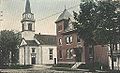 Congregational Church c. 1915


Geography
According to the
Roads and adjacent communities
The town is served by
Demographics
| Census | Pop. | Note | %± |
|---|---|---|---|
| 1800 | 2,503 | — | |
| 1810 | 2,632 | 5.2% | |
| 1820 | 2,795 | 6.2% | |
| 1830 | 2,988 | 6.9% | |
| 1840 | 3,001 | 0.4% | |
| 1850 | 3,088 | 2.9% | |
| 1860 | 3,252 | 5.3% | |
| 1870 | 3,351 | 3.0% | |
| 1880 | 3,233 | −3.5% | |
| 1890 | 2,888 | −10.7% | |
| 1900 | 2,540 | −12.0% | |
| 1910 | 2,822 | 11.1% | |
| 1920 | 2,870 | 1.7% | |
| 1930 | 3,035 | 5.7% | |
| 1940 | 3,494 | 15.1% | |
| 1950 | 4,742 | 35.7% | |
| 1960 | 5,767 | 21.6% | |
| 1970 | 7,839 | 35.9% | |
| 1980 | 10,101 | 28.9% | |
| 1990 | 11,856 | 17.4% | |
| 2000 | 14,141 | 19.3% | |
| 2010 | 16,381 | 15.8% | |
| 2020 | 18,336 | 11.9% | |
| U.S. Decennial Census[10] | |||

2010 census
As of the census
There were 5,719 households, of which 36.0% had children under the age of 18 living with them, 57.1% were married couples living together, 9.9% had a female householder with no husband present, 4.0% had a male householder with no wife present, and 28.9% were non-families. 21.8% of all households were made up of individuals, and 9% had someone living alone who was 65 years of age or older. The average household size was 2.59 and the average family size was 3.03.
The median age in the town was 38 years. 22.6% of residents were under the age of 18; 15% were between the ages of 18 and 24; 22.8% were from 25 to 44; 27.8% were from 45 to 64; and 11.9% were 65 years of age or older. The gender makeup of the town was 48.3% male and 51.7% female.
2000 census
As of the census
There were 4,875 households, out of which 38.7% had children under the age of 18 living with them, 59.2% were married couples living together, 10.0% had a female householder with no husband present, and 27.6% were non-families. 20.5% of all households were made up of individuals, and 8.3% had someone living alone who was 65 years of age or older. The average household size was 2.67 and the average family size was 3.11.

In the town, the population was spread out, with 25.9% under the age of 18, 13.7% from 18 to 24, 28.9% from 25 to 44, 21.5% from 45 to 64, and 10.0% who were 65 years of age or older. The median age was 34 years. For every 100 females, there were 93.8 males. For every 100 females age 18 and over, there were 90.2 males.
The median income for a household in the town was $50,316, and the median income for a family was $55,434. Males had a median income of $37,828 versus $30,394 for females. The per capita income for the town was $21,174. About 5.1% of families and 7.4% of the population were below the poverty line, including 9.7% of those under age 18 and 6.7% of those age 65 or over.
Education
Schools in Gorham are part of the Gorham School District. Heather Perry is the Superintendent.[citation needed]
The school district has three elementary schools (Village, Great Falls, and Narragansett), a middle school and a high school. For the 2011 to 2012 school year, the district had approximately 2,698 students enrolled.[13]
Notable people

- Wendell Abraham Anderson, politician
- James Phinney Baxter, historian, civic leader
- Maine
- James Boyle, state legislator
- Joseph Brackett, elder in Shakers sect and songwriter, most notably of Simple Gifts
- Bob Crowley, winner of Survivor: Gabon, physics teacher at Gorham High School
- Hiram Edson, a pioneer of the Seventh-day Adventist Church
- Edwin Hall, physicist
- Isaiah H. Hedge, MD, abolitionist, early donor to Bates College, physician
- Mackenzie Holmes, women's basketball player
- Charles Davis Jameson, lumberman, general
- Stephen Longfellow, US congressman
- James Mann, US congressman
- Peter Mills, former member of the Maine state Senate, raised in Gorham
- 2018 candidate for Governor of Maine, born in Gorham
- Josiah Pierce, Maine state senator and lawyer
- Rodney S. Quinn, Secretary of State of Maine (1979–1988)
- governor of Maine
- Linda Sanborn, state legislator
- Donald F. Snow, US congressman
- Ellen G. White, co-founder of the Seventh-day Adventist Church
- Horace Wilson, professor and baseball promoter
- Eric Saindon,VFX supervisor
See also
References
- ^ a b "US Gazetteer files 2010". United States Census Bureau. Retrieved December 16, 2012.
- ^ "Census - Geography Profile: Gorham town, Cumberland County, Maine". Retrieved January 11, 2022.
- ^ Josiah Pierce. A History of the town of Gorham, Maine. p. 169
- ^ Hugh Davis McLellan, History of Gorham, Maine; Smith & Sale, printers; Portland, Maine 1903
- ^ Coolidge, Austin J.; John B. Mansfield (1859). A History and Description of New England. Boston, Massachusetts: A.J. Coolidge. pp. 141–142.
coolidge mansfield history description new england 1859.
- ^ Chadbourne, Ava H. (April 20, 1949). "Many Maine towns bear names of military men". Lewiston Evening Journal. pp. A-2. Retrieved October 17, 2015.
- ^ Varney, George J. (1886), Gazetteer of the state of Maine. Gorham, Boston: Russell
- ^ Johnson, Ron (n.d.). Maine Central R.R. Mountain Division. 470 Railroad Club.
- ^ a b Wright, Virginia. "Gorham at a Crossroads". Down East: The Magazine of Maine (June 2010).
- ^ "Census of Population and Housing". Census.gov. Retrieved June 4, 2015.
- ^ "U.S. Census website". United States Census Bureau. Retrieved December 16, 2012.
- ^ "U.S. Census website". United States Census Bureau. Retrieved January 31, 2008.
- ^ "Gorham School District". Gorham School District. Retrieved June 6, 2012.
External links
- Town of Gorham official website
- Baxter Memorial Library
- Gorham Historical Society
- Maine Genealogy: Gorham, Cumberland County, Maine
43°40′46″N 70°26′39″W / 43.67944°N 70.44417°W
Municipalities and communities of Cumberland County, Maine, United States | ||
|---|---|---|
| Cities |  | |
| Towns | ||
| CDPs |
| |
| Other villages | ||
| ||
| International | |
|---|---|
| National | |