
Güssing
Güssing | ||
|---|---|---|
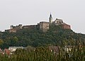
 Güssing Castle | ||
|
Postal code 7540 | ||
| Website | www.guessing.co.at | |
Güssing (German pronunciation:

History
Overview
The origins of Güssing date back to 1157, with the construction of the castle alongside a small settlement nearby. By 1355, Güssing had been granted special rights by Louis IV.[2] During the Middle Ages, religion, art and crafts were of great importance. As a border town, Güssing was fortified in order to repel attacks from what is now Hungary. Despite the threat of invasion Güssing prospered, with residents of the town at the time including the Artois botanist Carolus Clusius, and Johann Manlius, a typographer.[3] There is an homage to Clusius in the town, as well as a street named after him, the Clusiusweg.
In the 16th century, Güssing was a free imperial city with full municipal laws. In 1619, the town was surrounded with an enceinte, a type of town wall. The town at the time contained four quarters- Vorstadt, untere Stadt by the mansion of the Drašković family, innere Stadt from the monastery to the town hall and Hochstadt.
The lords of Güssing (in Hungarian: Kőszeg, in Slovak: Kysak) were a noble family in the frontier region of Austria and the Kingdom of Hungary. Note that Kőszeg is the name of a nearby Hungarian town (known as Güns in German) to which that family moved its residence from Güssing in 1274. In 1522, it became the residence of the Batthyány family, one of the most distinguished magnate families in Hungary. The family still Batthyány own the ancestral seat of Güssing Castle. In 1540, Franz Batthyány gained the magnate from Ferdinand I, the incumbent king of Hungary, Croatia and Bohemia, which allowed him to open up ore mines, whilst in 1549, he was granted the right to hold markets in the town by the emperor. A market still takes place on the first Monday of every month in the town.
The area, like the rest of what is now Burgenland, belonged to
In the 20th century, Güssing struggled economically due to its proximity to the Hungarian border, and with it the Iron Curtain during the Cold War. Many residents moved elsewhere or commuted for long distances to find work.[4]

Geography
The town is situated in the south of Burgenland, close to the Hungarian border, in the valley of the river Strem at a height of 229 metres above sea level.[5] Just under half of the area is agricultural land, whilst nearly 40% is forested. The town is neighboured by Tobaj to the north, Strem to the east, Heiligenbrunn to the southeast, Kleinmürbisch and Großmürbisch to the south, Neustift bei Güssing to the southwest and Gerersdorf-Sulz to the northwest. The Güssing fish ponds are a designated Ramsar site within the town, known for its bird populations of little bittern, grey heron and great crested grebe.[6]
Renewable energy
The town is also known for its renewable energy projects. During the 1980s, Peter Vadasz, a local councillor, and Reinhard Koch, a technical engineer, created an energy transition strategy for the town by using local wood as an energy source.
International Relations
Güssing is twinned with:
-
-
 An homage to Carolus Clusius, a resident of the town
 -
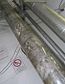
 Wood gasifier (commercial operation)
 -
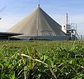
 Fischer-Tropsch diesel production from gasified wood (Pilot)
 -
 Biogas plant Strem
 -
 Biogas fuelled engine Biogas plant Strem


Neighbourhoods
The neighbourhoods that make up the town area include (with the population as of January 2021 in brackets):
- Glasing (123) with the Glasing mountains
- Güssing (Kernstadt) (2725) with Langzeil, Ludwigshof and Rosenberg
- Krottendorf (212)
- Sankt Nikolaus (193)
- Steingraben (182)
- Urbersdorf (230)
Culture
- The main attraction of the district is Güssing castle. Built on a volcanic cone, the castle is known for its exhibition "400 years of art", the gothic castle chapel (with a neo-gothic, wooden carved high altar, an old chest organ and a baroqueside altar. The castle also contains a museum and a restaurant.
- A romanesque parish church dates back to the 1200s, with a cemetery nearby.
- The town contains a Franciscan monastery, which was built at the same time as a bastion of the town wall and a monastic church, the Visitation of Mary church. Built in 1863, the monastery contains a range of renaissance architectural elements. The monastery is also noted for a paramental shrine in the sacristy and the library with many unique works from the age of Protestantism. Under the monastery is the crypt of the family Batthyány, which is the second largest of its kind in Austria, with a state coffin by K. Moll. There is also a shrine depicting the beatification of László Batthyány-Strattmann.
- There is a two-storey, castle like arcade in the town.
- In the east of the town is the family home of the classicist style mansion with empire stylefurniture and a gothic winged altar from 1450 in the house chapel.
Regular events
- Musical Güssing: The cultural association hosts several events each year. In late January a carnival show takes place in the heart of Güssing. Every September a well-known musical show is performed, in which amateurs and professionals work together. The actor and singer Florian Resetarits (de) began his career in these musicals.
- Castle performances: For the last 500 years, Güssing has been a cultural centre, with the theatre being of particular significance. The castle performances are a highlight of the summer programme. The actor Frank Hoffmann was the most recent director of the Güssing summer programme, as part of which performances take place at Güssing castle. The Güssing castle association hosts theatre performances for adults and children on the fairground at the foot of the castle.
Sport
The town has a football club, SV Güssing, which play in the Landesliga Burgenland, the fourth division of Austrian football. The town is home to a basketball club, UBC Güssing Knights.
Notable people
- Batthyány-Strattmann family
- Franjo Baćan) (1497, Buda - 1566) (hu)
- Bishop of Transylvania (de)
- Gusztáv, 5th Prince Batthyány-Strattmann (1803–1883), owner and breeder of race-horses
- Prince Edmund Batthyany-Strattmann(1826–1914)
- Prince László Batthyány-Strattmann (1870, Dunakiliti - 1931), doctor and blessed of the Roman Catholic Church
- István Beythe (1532–1612), bishop, botanist (hu)
- Julia Dujmovits (born 1987), snowboarder
- Ferenc Faludi (German: Franz Faludi, 1704–1779) (de)
- Samuel Steinherz, errorly "Steinberg" (1857–1942), Jewish historian born here[7]
- Josef Reichl (1860–1924)
- Carolus Clusius (1526-1609)
- Jenő Nagy (1898–1944) (hu)
- Otto Kery (1923–2006), director, editor, actor (de)
- Peter Vadasz (born 1944), City Mayor
- Reinhard Koch (born 1959), together with Vadas the "creator" of energy-independent Güssing
- Josef Trinkl (1951–2004), politician (de)
- Heinz Janisch (born 1960), author (de)
- Ägidius Zsifkovics (born 1963), theologian, Bishop of Eisenstadt
- Sabine James circus-artist, harpist, performer, theatre-director (Burgspiele Güssing)
- Martin Stranzl (born 1980), football player
- Michael Miksits (born 1981), football player (de)
- Kabarettist
- Csákányi László (1921-1992), színész, schauspieler (hu)
See also
References
- DI Dean Marcelja (ECRE AG) & Geraldine Faulkner (Sustainable Solutions), 2008
- ^ "Dauersiedlungsraum der Gemeinden Politischen Bezirke und Bundesländer - Gebietsstand 1.1.2018". Statistics Austria. Retrieved 10 March 2019.
- ^ "Güssing Eine Stadt Stellt Sich Vor" (PDF). Guessing.co.at. 1997. Retrieved 27 August 2022.
- ^ "Güssing Eine Stadt Stellt Sich Vor" (PDF). Guessing.co.at. 1997. Retrieved 27 August 2022.
- ^ .
- ^ "Güssing in Zahlen". Güssing.at. Retrieved 30 May 2022.
- ^ Holler, Christian. "Ramsar-Gebiet Güssinger Fischteiche Management Plan Dezember 14" (PDF). Naturschutz Burgenland (in German). Retrieved 3 June 2022.
- ^ "Gerhard Oberkofler: Samuel Steinherz (1857-1942)". Archived from the original on 2009-07-22. Retrieved 2009-08-13., Steinberg: [1], "DotRoll Domain Regisztráció". Archived from the original on 2011-07-20. Retrieved 2009-08-13.
External links
- Official Website of Güssing
- Biomass gasification power plant Güssing Archived 2008-10-13 at the Wayback Machine
- Biogas plant Strem Archived 2008-10-13 at the Wayback Machine
- Official Website of the Batthyany Family
- Official Website of the Foundation of the castle of Guessing
| International | |
|---|---|
| National | |
| Geographic | |