
Galveston Seawall
Galveston Seawall | |
Texas State Antiquities Landmark | |
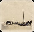
 Galveston Seawall during construction | |
 Galveston Seawall  Galveston Seawall | |
| Location | Seawall Blvd., Galveston, Texas |
|---|---|
| Coordinates | 29°18′09″N 94°46′27″W / 29.30250°N 94.77417°W |
| Area | 8 acres (3.2 ha) |
| Built | 1902 |
| Built by | J.M. O`Rourke & Co. |
| Architect | Gen. H.M. Robert |
| Architectural style | Protective Seawall |
| NRHP reference No. | 77001443[1] |
| TSAL No. | 8200000269 |
| Significant dates | |
| Added to NRHP | August 18, 1977 |
| Designated TSAL | January 1, 1981 |
The Galveston Seawall is a
Description
Although the Seawall performed as intended, it created an unintended and insurmountable consequence: passive erosion resulting in the gradual disappearance of the once-wide beach and the resort business with it. "Within twenty years, the city had lost one hundred yards of sand. People who once watched auto racing on a wide beach were left with a narrow strip of sand at low tide and a gloomy vista of waves on rocks when the tide was high."[3] Houston soon overtook Galveston as the major city in the region.
Reporting in the aftermath of the 1983 Hurricane Alicia, the Corps of Engineers estimated that $100 million in damage was avoided because of the seawall.[4] On September 13, 2008, Hurricane Ike's large waves over-topped the seawall.[5] As a result, a commission was established by the Texas governor to investigate preparing for and mitigating future disasters.[6]
A proposal has been put forth to build an "Ike Dike", a massive levee system that would protect the Galveston Bay and the important industrial facilities that line the coast and the Houston Ship Channel from a future, potentially more destructive storm. The proposal has gained widespread support from a variety of business interests. As of 2009[update] it is only at the conceptual stage. Further proposals for a layered network of smaller, local levees and natural protections have been put forward by the SSPEED Center at Rice University and the University of Houston. These proposals include a surge gate at the mouth of the Houston Ship Channel connecting adjacent high ground near the Hartman Bridge and hard protections for the west shore of Galveston Bay and around the densely developed east end of Galveston Island. Also included is the proposed lower coastal Lone Star Coastal National Recreation Area.
Texas
The seawall is 10 miles (16 km) long. It is approximately 17 feet (5.2 m) high and 16 feet (4.9 m) thick at its base. The seawall was listed in the
Many miles of the seawall are painted with
Gallery
-
 Postcard of the construction of the Galveston Seawall, undated.
 -
 Postcard of the Galveston Seawall, undated.
 -
 Damage to Seawall after 1915 Hurricane.
 -
 Galveston Seawall paintings.
 -
 Sea Wall and beach, Galveston, Texas (postcard, circa 1907).
 -
 Workers repairing Seawall Boulevard after 1915 Galveston hurricane.
.jpg)
.jpg)


See also
References
- ^ "National Register Information System". National Register of Historic Places. National Park Service. November 2, 2013.
- ^ SEAWALL Archived 2009-03-21 at the Wayback Machine Accessed 2008-09-17.
- ^ "Against the Tide".
- ^ "Hurricane Alicia, 1983". USA Today. September 21, 2005. Retrieved February 12, 2017.
- ^ Casselman, Ben (September 12, 2008). "As Waters Rise, Many Decline To Leave Galveston Island". The Wall Street Journal. Retrieved September 13, 2008.
By 4 p.m., waves were overtopping the city's 17-foot-tall seawall and parts of...island were unreachable even by rescue crews.
- ^ Casselman, Ben (June 4, 2009). "Planning the 'Ike Dike' Defense". Wall Street Journal.
- ^ Galveston, Texas Outdoor Recreation & Nature Accessed 2012-03-15.
- ^ Moran, Kevin (September 9, 1990). "City has raised storm preparedness to a fine art". Houston Chronicle.
- ^ "Galveston Seawall and Grade Raising Historical Marker". The Historical Marker Database. Retrieved April 23, 2021.
Further reading
- Austin, A. (March 1905). "Galveston, The City Reclaimed: Marvelous Recuperation of a Town Wiped Out Four Years Ago". Pearson's Magazine. XIII (3): 211–219. Retrieved July 15, 2009.
- Gillette, Halbert Powers; Hill, Charles Shattuck (1908). Concrete Construction: Methods and Cost. New York: The Myron C. Clark Publishing Co. pp. 268–269. Retrieved July 15, 2009. (Diagrams of the movable concrete mixer plant used for construction of the seawall)
- Putnam, Frank (June 1907). "Galveston, An Epitome Of American Pluck". The New England Magazine. XXXVI (4): 387–403. Retrieved July 15, 2009.
- Shaw, Albert (November 1903). "Galveston's Great Sea Wall". The American Monthly Review of Reviews. XXVIII: 574–576. 5. Retrieved July 15, 2009.
- Slosson, W. B. (June 16, 1904). "The New Galveston". The Independent. LVI (2898): 1382–1387. Retrieved July 15, 2009.
- Williams, Clement Clarence (1922). The Design Of Masonry Structures And Foundations. New York: McGraw-Hill Book Company. p. 248. Retrieved July 15, 2009. (Diagram and description of the geometry of the seawall to dissipate wave energy)
- "Raising the Grade of Galveston". Locomotive Firemen's Magazine. XXXVI (5): 643–647. May 1904. Retrieved July 15, 2009.
External links
- One-hundred-year-old photos of the Galveston seawall Archived September 17, 2008, at the Wayback Machine
