
Gouraya National Park
| Gouraya National Park | |
|---|---|
 The Aiguades | |
 | |
| Location | Béjaïa Province, Algeria |
| Nearest city | Béjaïa |
| Coordinates | 36°46′N 5°6′E / 36.767°N 5.100°E |
| Area | 20.8 km2 (8.0 sq mi) |
| Established | 1984 |
| Visitors | 60.000 (in 2005) |
 | |
The
History
The park became an Algerian National Park in 1984, and has been
Description
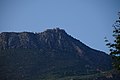
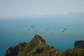
The park owes its name to the Gouraya Mountain (altitude 660m) located within the park's boundaries.[2] The ground elevation in the park oscillates between -135m and 660m. There is also a lake, the Lake Mézaïa.[1]
The park is located on a calcaro-dolomitic ground.[3]
The park is north-east of
Population
The permanent population in the Gouraya National Park is of Berber origins, 1,655 inhabitants across 13 villages.[1]
Wildlife

The park is home to a wide variety of flora and fauna, including Barbary macaques and jackals who live in the park's forests. The Barbary macaque is a primate with a very restricted range in portions of northwestern North Africa and disjunctively in Gibraltar.[1]
In 2011, the French
- Quercetea ilicis Braun-Blanquet (1947)
- Querco-Fagetea Braun-Blanquet & Vlieg (1937)
- Crithmo-limonielea Braun-Blanquet (1947)
- Asplenietea rupestris (H.M) Braun-Blanquet (1934)
- Protected fauna[1]
- Tree spurge (Euphorbia dendroides)
- Prickly juniper (Juniperus oxycedrus)
- Endangered animals[1]
- barbary apes (Maccaca sylvanus)
- Jackals (Canis aureus algeriensis)
- Wild cats (Felis silvestris)
- Algerian hedgehogs (Erinaceus algirus)
- Marine mammals of national importance[1]
- Sperm whales (Physeter macrocephalus)
- Short-beaked common dolphins (Delphinus delphis)
- Bottlenose dolphins (Tursiops truncatus)
- Harbour porpoises (Phocoena phocoena)
Gallery
-
 Yemma Gouraya, next to Béjaïa.
 -
 The city of Bougie at the base of Yemma Gouraya mountain.
 -
 Monkeys' peak (Pic des singes), above the Cap Carbon.
 -
 Fort Gouraya, which culminates at 672m.
 -
 Dead fish on the river Summam, probably frompesticide pollutiondue to heavy rains (2008).


References
- ^ a b c d e f g Biosphere Reserve Information, Unesco.org, 3 April 2006
- ^ Gouraya National Park - Biodiversity at its Best, Algeria.com
- ^ a b K. Rebbas, Errol Véla, Approche phytosociologique du Parc National de Gouraya (Béjaïa, Algérie), Inra.fr, 2011