
Hainault Loop
Hainault Loop | |||||||||||||||||||||||||||||||||||||||||||||||||||||||||||||||||||||||||||||||||||||||||||||||||||||||||||||||||||||||||||||||||||||||||||||||||||||||||||||||||||||||||||||||
|---|---|---|---|---|---|---|---|---|---|---|---|---|---|---|---|---|---|---|---|---|---|---|---|---|---|---|---|---|---|---|---|---|---|---|---|---|---|---|---|---|---|---|---|---|---|---|---|---|---|---|---|---|---|---|---|---|---|---|---|---|---|---|---|---|---|---|---|---|---|---|---|---|---|---|---|---|---|---|---|---|---|---|---|---|---|---|---|---|---|---|---|---|---|---|---|---|---|---|---|---|---|---|---|---|---|---|---|---|---|---|---|---|---|---|---|---|---|---|---|---|---|---|---|---|---|---|---|---|---|---|---|---|---|---|---|---|---|---|---|---|---|---|---|---|---|---|---|---|---|---|---|---|---|---|---|---|---|---|---|---|---|---|---|---|---|---|---|---|---|---|---|---|---|---|---|
| |||||||||||||||||||||||||||||||||||||||||||||||||||||||||||||||||||||||||||||||||||||||||||||||||||||||||||||||||||||||||||||||||||||||||||||||||||||||||||||||||||||||||||||||
The Hainault Loop, originally opened as the Fairlop Loop, is a 6.5-mile (10.5 km)
History

The GER built the line to foster suburban growth in
First to go was the westward curve between Newbury Park Junction and Ilford Carriage Sidings Junction, on 30 November 1947.[2] The other connection to Seven Kings West Junction was goods only and survived until 19 March 1956.[2] The whole triangular junction disappeared under expansion of Ilford carriage sheds in 1959.[4] Goods trains operated by British Rail continued using the loop via Woodford as far as Newbury Park until 4 October 1965.[5] A short turn-back siding was provided on the former track-bed south of Newbury Park: after goods trains were withdrawn it was used by engineers' trains until 1992.[6]
Layout
Woodford to Ilford
The Loop was double track and all six original stations had two 600 ft (183 m) platforms: the 1936 station at Roding Valley had 500 ft (152 m) platforms. Hainault station re-opened in 1948 with a third platform[7] It is today used by terminating Central line trains. A fork at the northern end at Woodford Junction let trains leave or join the Ongar branch. A triangular junction at the southern end gave access to the main line, the site now occupied by Ilford carriage sheds and a maintenance depot run by Bombardier. The apex of the triangle was Newbury Park Junction (just south of Vicarage Lane), the western side was Ilford Carriage Sidings Junction, and the eastern side was Seven Kings West Junction.

The topography challenged engineers.[8] The line was on the surface but 260 yards (238m) of tunnel was bored immediately north of Grange Hill. The line between Roding Valley and Chigwell was on an embankment, and a three-arch viaduct was built over the River Roding. Further east, the embankment was bisected by the London end of the M11 motorway in 1977,[9] a concrete bridge carrying the line over the road. Chigwell and Grange Hill were built in cuttings, Hainault and Fairlop on embankment, and most of the route south of Barkingside including Newbury Park was in a cutting. Only the platforms at Roding Valley and Barkingside (eastbound only) are accessible from street level. Works for accessibility to each of the platforms at Roding Valley were completed in 2009; hitherto there were a couple of steps to street level.
Goods yards were at Grange Hill (closed 1965), Hainault (closed 1908), Fairlop (closed 1958), Barkingside and Newbury Park (both closed 1965).[10] One of the former sidings at Newbury Park is now the eastbound through line, with the former eastbound line normally used only for reversing, though it retains the connection facing Barkingside. The sidings at Grange Hill now form part of the north-facing access from Hainault Depot. They extend parallel to the station platforms, and there are also sidings at the southern end of the depot next to the platforms at Hainault. East of Chigwell a short siding served Chigwell Nursery in GER days, but this was closed, probably before Grouping into the LNER (the nursery was sold in 1922[11]).
Newbury Park to Leytonstone
The line between Leytonstone and Newbury Park is of standard twin-bore construction, with the three intermediate stations all having central platforms. The route diverges from the
Stations
Stations served
From north-west to south-east
- Woodford, opened 22 August 1856 by the Eastern Counties Railway (ECR), closed briefly, re-opening 14 December 1947.[2]
Fairlop Loop diverges from the Ongar (now Epping) Branch at Woodford Junction
- Roding Valley, opened 3 February 1936 as Roding Valley Halt by the LNER, closed 29 November 1947, re-opening 21 November 1948.[2]
- Chigwell, opened 1 May 1903 by the GER, closed 29 November 1947, re-opening 21 November 1948.[2]
- Grange Hill, opened 1 May 1903 by the GER, closed 29 November 1947, re-opening 21 November 1948.[2]
- Hainault, opened 1 May 1903 by the GER, closed 1 October 1908 to 3 March 1930. Closed 29 November 1947, re-opening 31 May 1948.[2]
- Fairlop, opened 1 May 1903 by the GER, closed 29 November 1947, re-opening 31 May 1948.[2]
- Barkingside, opened 1 May 1903 by the GER, closed 22 May 1916 to 30 June 1919. Closed 29 November 1947, re-opening 31 May 1948.[2]
- Newbury Park, opened 1 May 1903 by the GER, closed 29 November 1947, re-opening 14 December 1947 as part of the Central line.[2]
- Former connection: Fairlop Loop joins Great Eastern Main Line via westward curve between Newbury Park Junction and Ilford Carriage Sidings Junction
- Ilford, opened 20 June 1839[15] by the Eastern Counties Railway. Operated by the Elizabeth line. Connection closed 30 November 1947.[2]
- Former connection (freight-only): Fairlop Loop joins Great Eastern Main Line via eastward curve between Newbury Park Junction and Seven Kings West Junction
- Seven Kings, opened 1 March 1899[15] by the GER. Operated by the Elizabeth line. Connection closed 19 March 1956.[2] (not served by scheduled Fairlop Loop passenger trains)
Remainder of Fairlop loop connects with Central line tube from Leytonstone (nowadays both parts referred to as the "Hainault Loop")
- Gants Hill, opened by LTE 14 December 1947.[2]
- Redbridge, opened by LTE 14 December 1947.[2]
- Wanstead, opened by LTE 14 December 1947.[2]
re-joins the Ongar (Epping) Branch at Leytonstone Junction
- Leytonstone, opened 22 August 1856 by the ECR, closed briefly, re-opening 5 May 1947.[2]
Station architecture
Most of the surface stations on the Fairlop loop and the underground stations on the Hainault loop are notable for their architecture, dating from Edwardian to the London Transport style of the 1930s/1940s. The bus station shelter at Newbury Park won a Festival of Britain award in 1951, and both it and Barkingside station are Grade II Listed buildings.[16][17] The interior of Gants Hill was heavily inspired by the Moscow Metro.[12] Gants Hill lacks a proper station building, being directly underneath the busy A12 roundabout. Due to bomb damage to Grange Hill in 1944,[18] and expansion of the A12 Eastern Avenue at Newbury Park in 1956,[19] the original station buildings were demolished. They were almost identical to that at Chigwell. Newbury Park was meant to receive a replacement building but it was never built, and the only entrance is via the bus station. Hainault's original structure, prior to rebuilding due to the addition of Hainault Depot, was very similar to that at Fairlop.[20] Roding Valley had rather basic buildings on opening, with a wooden shelter on the Woodford-bound side, replaced by more substantial structures when transferred to the Central line. Notable architects included Oliver Hill for Newbury Park bus station and W. N. Ashbee for the original six stations from Chigwell to Newbury Park (though the Listing authorities credit William Burgess for Barkingside, possibly erroneously). Renowned London Underground architect Charles Holden designed the three new underground stations that opened in 1947.[21]
-
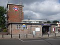
 Roding Valley (new building 1949)
 -

-
 Grange Hill (new building 1949)
 -
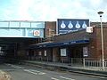 Hainault (new building 1949)
 -

-

-
 Newbury Park bus station
 -
-
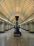 Gants Hill interior
 -
-


Service pattern
Since 1947 (Central line)
Typical off-peak service pattern (as of 2007):[22]
- Through trains central London - Leytonstone - Hainault via Newbury Park: every 6-10 mins until c. 01:00.
- as above but additionally Hainault - Woodford: every 20 mins until 24:00.
- additional trains from White City to Newbury Park, every 20 mins.
Before 1947 (GER/LNER)
Typical service pattern by 1933 (LNER):[23]
- Half-hourly during the day, circular service typically London Liverpool Street - Stratford - Ilford - Woodford - Stratford - London Liverpool Street.
Rolling stock
Since 1947 (Central line)
- Standard tube stock1947-1963 (final withdrawal)
- 1959 tube stock1960-1964
- 1962 tube stock1962-1995 (final withdrawal)
- 1992 tube stock1993–present
- Hainault - Woodford shuttle service saw a variety of stock from the early 1960s in conjunction with experimental 1973 tube stock,[25]prior to introduction of the 1992 trains.
Before 1947 (GER/LNER)
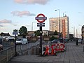
The closed connection today
The connection between Ilford/Seven Kings and Newbury Park is approximately 0.8 miles (1.3 km) long, and is still evident at ground level despite the track being lifted many years ago. From south to north, there are three road bridges - Vicarage Lane, Benton Road and Wards Road - crossing a missing alignment: much of the route was in a cutting that has been filled in since the line closed.
South of Newbury Park, the inclines to/from the tunnel portals towards Gants Hill diverge away from the former route. Immediately to the south is an
-
 The A12 Eastern Avenue crosses the Central line just to the south of Newbury Park, with the eastbound tunnel portal to the right of the remains of the old route to Ilford.
 -
 From the A12 looking south of Newbury Park showing the present route to Gants Hill diverging from the former alignment to Ilford and Seven Kings. An eastbound train has just emerged from the portal.
 -
 Bridge on Wards Road looking east. Newbury Park is a few hundred yards to the north: to the south and immediately to the north allotments occupy the alignment. The former route was in a cutting that has been filled in.
 -
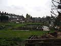 Looking south from Wards Road along the former alignment. Allotments now occupy the route as far as Benton Road just visible in the distance.
 -
 Looking west towards the bridge on Benton Road, similar to that on Wards Road but with pavements on both sides. The former route here was in a cutting.
 -
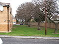 Looking north from the new Friars Close towards Benton Road, St Aidan's School lying just beyond the fence. Most, but not all, of the residential buildings lie just off the old alignment, marked by these trees.
 -
 Looking south from Vicarage Lane towards the flats of the eastern half of the Piper Way development, new in 2008. The block of flats nearest the camera occupies the site of the old Newbury Park Junction. In the distance on the extreme left, part of Ilford Car Sheds is visible.
 -
 Looking north towards Vicarage Lane bridge from the blocks of flats on Piper Way, illustrating that the former route was still in a cutting this far south. The photo was taken on the site of the old Newbury Park Junction. Ilford Car Sheds lie directly to the south of this estate.


Ilford to Newbury Park: modern alternatives
The recent construction of residential blocks and the long-standing and ongoing use of the alignment for allotment gardens mean that there can be no re-instatement of the line between Ilford and Newbury Park. The Central line serves both Stratford and Liverpool Street, just as Fairlop Loop services did, and to travel by rail between Newbury Park and Ilford requires a change of trains at Stratford. Alternatively,
See also
References
Citations
- ^ "Cravens Heritage Trains - History". Archived from the original on 16 March 2013. Retrieved 19 March 2008.
- ^ a b c d e f g h i j k l m n o p q r Connor 2007, p. IV
- ^ "Electrifying London - The 1935-1940 New Works Programme". Archived from the original on 1 April 2008. Retrieved 14 March 2008.
- ^ a b Brennand 2006, p. 10
- ^ Connor 2007, p. 115
- ^ Connor 2007, p. 117
- ^ due to rebuilding associated with construction of the nearby depot. (Connor 2007, p. 101)
- ^ Jackson 1999, p. 395
- ^ Motorway Archive - M11 dates
- ISBN 978-0-7110-3137-1.
- ^ Connor 2007, p. 89
- ^ a b Connor 2007, p. 118
- ^ "Factory in an Uncompleted London Tube Tunnel". The Railway Magazine. Vol. 92, no. 563. Westminster: Railway Publishing Co. May–June 1946. p. 160.
- ^ "Central line facts". Transport for London. Archived from the original on 2 December 2010. Retrieved 7 November 2018.
- ^ a b Brennand 2006, p. IV
- ^ Newbury Park station Grade II Listing
- ^ Barkingside station Grade II Listing
- ^ Connor 2007, p. 94
- ^ Connor 2007, p. 114
- ^ Connor 2007, p. 99
- ^ Charles Holden station photo gallery Archived 31 March 2008 at the Wayback Machine
- ^ Clive's UndergrounD Line Guides - Central line services
- ^ Connor 2007, p. X
- ^ a b Bruce & Croome 2006, p. 69
- ISBN 0-7110-1460-4.
- ^ Jackson 1999, p. 396
- ^ London Bus Routes - List of routes
Bibliography
- Connor, J E (2007). Branch Line to Ongar. Middleton Press. ISBN 978-1-906008-05-5.
- Jackson, Alan A (1999). London's Local Railways. Capital Transport. ISBN 1-85414-209-7.
- Brennand, Dave (2006). Ilford to Shenfield. Middleton Press. ISBN 1-901706-97-4.
- Bruce, J Graeme; Croome, Desmond F (2006). The Central Line. Capital Transport. ISBN 1-85414-297-6.
External links
- Clive's UndergrounD Line Guides - Central line
- Electrifying London - The 1935-1940 New Works Programme
- Transport for London's London Underground website
- Cravens Heritage Trains - History of the GER/LNER branch lines in London
- The Great Eastern Railway Society
- The London & North Eastern Railway (LNER) Encyclopedia
- New Popular Edition Maps - view a 1946 map of the entire Fairlop Loop just prior to takeover by the Central line.
- Heritage Gateway - Online resources including searchable database of Listed Buildings Online