
Hallam Street
no junction |

Hallam Street is a road situated in the Parish of St
History
Hallam Street is situated within the boundaries of the ancient Manor of
Like the better known
Buildings and notable residents


The street has buildings of mainly five to eight storeys with a strong residential presence.
Number 50 Charlotte Street (later renamed 93 Hallam Street) was both the home and official residence from 1875 to 1910 of Jesse Claxton who was the Registrar of Births and Deaths for St Marylebone for 35 years.
Numbers 44 and 50 Hallam Street, originally the offices of the

Hallam Street contains a number of institutional buildings (including the
Recent developments
The redevelopment of Broadcasting House, whose modern rear elevation lies on Hallam Street, was completed in 2010. Its redevelopment is the BBC's single largest capital project ever, and has created a new centre for radio, news and world service in the heart of London.[15] The BBC's facilities, a majority of the street's office buildings and its two hotels lie at the southern end of the street.
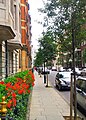
Trees were planted along the length of the street in 2009 and residential fibre-optic broadband infrastructure was also added to it in 2019.[16][17]
Notable buildings
There are a number of notable buildings on this Marylebone Street:
- Broadcasting House (BBC)
- 44 and 50 Hallam Street (Formerly the offices of the General Medical Council) - Conference venue and residential
- 47 Hallam Street (The Central London Synagogue) - Place of worship
- 49 Hallam Street - Residential mansion block
- 77 Hallam Street - Residential mansion block
- 84-94 Hallam Street (Weymouth House) - Residential mansion block
- 105 Hallam Street (Formerly Cunard White Star Line Lodge) - Residential mansion block
- 110 Hallam Street (Rossetti House) - Residential mansion block
Other buildings with elevations on Hallam Street
- 85 New Cavendish Street – De Walden Court - Residential mansion block & offices
- 1 Weymouth Street (Weymouth Court)- Residential mansion block
- 2 Weymouth Street (formerly YMCA Hostel) - Residential mansion block
- 9 Weymouth Street (Stone House) - Residential mansion block
- 10 Weymouth Street (Warpole House) - Residential mansion block - www.10weymouth.com
- 2 Devonshire Street (formerly YWCA Hostel) - Residential mansion block
- 54-57 Devonshire Street (Goodwood Court) - Residential mansion block
Gallery
-
 View of Hallam Street outside Weymouth House in Marylebone London W1
 -
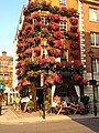 View of the Mason's Arms on Hallam Street in Marylebone London W1
 -
 View South on Hallam St, Marylebone London W1
 -
 Hallam Street before trees were planted
 -
 Lord Mayor Cllr Alan Bradley launches W1W Street Tree Planting campaign on Hallam Street W1
 -
 Air Raid Precautions Message regarding bombing incident at 44 Hallam Street on 3 June 1941
 -
 DANTE GABRIEL ROSSETTI 1828-1882 Poet & Painter was born at 110 Hallam Street


Transport
The nearest London Underground stations to Hallam Street are Oxford Circus, Great Portland Street, and Regent's Park tube stations. Buses numbered 88, 18, 27, 30, 205, 189, 3, 12 and 55 stop within a close distance (<5 minutes walk) from Hallam Street.[18]
See also
- List of eponymous roads in London
- UCL Survey of London Volumes on Hallam Street in South East Marylebone
References
- ^ "Harley Street Conservation Area Map September 2007" (PDF). Westminster City Council. Retrieved 21 May 2010.
- ^ "Marylebone District Map 1902". Gutenberg Project: Charles and Adam Black. Retrieved 20 May 2010.
- ^ Robertson, Edmund (1911). . In Chisholm, Hugh (ed.). Encyclopædia Britannica. Vol. 12 (11th ed.). Cambridge University Press. pp. 851–852.[verification needed]
- ^ "Harley Street Conservation Area Audit 2008" (PDF). Westminster City Council. Retrieved 21 May 2010.
- ^ "Horwood's Plan of the Cities of London and Westminster 1792-1799". Old London Maps Com. Retrieved 21 May 2010.
- ^ Image catalogue of Hallam St 2011 http://outdoors.webshots.com/album/577048690pTElbR
- ^ Gordon Mackenzie, Marylebone - Great City North of Oxford Street, Macmillan; 1st Edition (2 Nov 1972)
- ^ David Brandon and Alan Brook, Marylebone & Tyburn Past - An illustrated history of this wealthy suburb. Historical Publications, 2007
- ^ "WCC Conservation Area Audit June 2008". Westminster City Council. Archived from the original on 5 March 2010. Retrieved 21 May 2010.
- ^ "The Howard de Walden Estate from 1086 to present day". Howard de Walden Estate. Archived from the original on 22 March 2009. Retrieved 21 May 2010.
- ^ "History of Harley Street Area". Harley Street Guide. Retrieved 21 May 2010.
- ^ "History of Langham Estate". Langham Estate. Archived from the original on 23 March 2010. Retrieved 22 May 2010.
- ^ Revealed Samuel Tak Lee: the secretive tycoon who controls a huge swathe of the West End, Evening Standard, 13 June 2003, p.19
- ^ http://www.westendatwar.org.uk/page_id__117_path__0p2p.aspx West End at War web site, Bomb Damage File Nos. 105, 489, 491 & 549 of 1940-41, and Bomb Damage Maps, Westminster City Council Archive Centre, London, England
- ^ "New Broadcasting House". BBC British Broadcasting Corporation. Retrieved 23 May 2010.
- ^ w1wtrees (26 June 2009). "Trees Arrive on Hallam Street in Marylebone, London W1". The W1W Tree Planting Initiative for Marylebone. Retrieved 10 June 2019.
{{cite web}}: CS1 maint: numeric names: authors list (link) - ^ "Marylebone Association - Slow lane for Superfast Broadband rollout in (East) Marylebone". www.marylebone.org.
- ^ "Transport for London - Bus Routes May 2010". Transport for London. Retrieved 23 May 2010.
External links
- Marylebone Association website
- Hallam Street Facebook Community Page
- Hallam Street drawn into WCC Neighbourhood Forum Discussions
- Westminster City Council Conservation Area Audits
- BBC Broadcasting House Redevelopment Project web site
- The Howard de Walden Estate web site
- The Langham Estate web site
- Portland Village web site
- W1W Street Tree Initiative for Marylebone
- West End at War: Article on damage caused to Hallam Street by the bombing of 10-11 May 1941

