
Harburg, Bavaria
Harburg | |
|---|---|
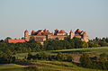
Wörnitz River and in the background St. Barbara and Herz Jesu, Harburg Castle , view from the castle on the town | |
_Flagge.svg) Flag _COA.svg) Coat of arms | |
Location of Harburg within Donau-Ries district | |
Donau-Ries | |
| Government | |
| • Mayor (2020–26) | Christoph Schmidt[1] (Ind.) |
| Area | |
| • Total | 73.17 km2 (28.25 sq mi) |
| Elevation | 413 m (1,355 ft) |
| Population (2022-12-31)[2] | |
| • Total | 5,612 |
| • Density | 77/km2 (200/sq mi) |
| Time zone | UTC+01:00 (CET) |
| • Summer (DST) | UTC+02:00 (CEST) |
| Postal codes | 86655 |
| Dialling codes | 09080 |
| Vehicle registration | DON |
| Website | www.stadt-harburg-schwaben.de |
Harburg (German:
The town is part of the scenic route called "Romantische Straße" (Romantic Road) with one of the most impressive remaining medieval castles in Germany.
History
Etymology
The name of the town is usually interpreted as deriving from the Middle High German term horo, meaning "Swamp or bog". Harburg Castle would be a castle above the swamp. However, the soil conditions in Harburg speak against this thesis. In the local dialect Harburg is still referred to as Hore. This could be the German word for horn, which indicates the shape of the castle hill. Harburg Castle would thus be a castle on a hill with a horn shape.
Middle Ages
Main sights
Harburg Castle
Old town
The village itself is quaint with his medieval old town, which blends picturesquely between the Wörnitz River and the castle hill.
The historic stone bridge from the 18th century is also worth seeing. The arched structure was built in 1729 after a devastating flood, consisting of stone blocks with seven bays and covered pillars. Suevit was also used as building material. In order to finance the maintenance of the bridge, the municipality has always had the right in the past to levy a bridge and pavement toll. At the end of World War II in 1945, two arches of the bridge were destroyed by explosions. The damage was completely repaired after the end of the war by a slight widening at this position.
Reached from the stony bridge you get to the old town and the market square with a bronze fountain, which tells a lot about the history of Harburg:
- The lower basin symbolizes with the guild signs of blacksmith, flaxbreaker, barrel-binder, fishermen and shoemaker the crafts that were formerly common in Harburg.
- The central basin shows different chapters from the city's history. There are also various figures from the mythical world of Harburg.
- The upper basin shows the silhouette of the castle and important historical data. The fountain closes with the “blood bell”, which is in the original on the roof of the town hall. By ringing the bell, the pronounced death sentence was announced in the past.
A further main sight would be the information point of the Geopark Ries, which is located since 2020 in the Donauwörher Street. This provides information about the formation of the giant
-
-
 Harburg Castle entrance
 -
 Harburg (view from Harburg Castle)
 -
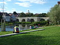 old stone bridge
 -
 fountain


_02.jpg)
Incorporated villages
Incorporated villages and districts are:[3]
- Brünsee
- Ebermergen
- Großsorheim
- Harburg (with Birkenhof, Bühlhof, Harthof, Kratzhof, Listhof, Salchhof, and Stadelhof)
- Heroldingen (with Brennhof and Tiefenmühle),
- Hoppingen
- Mauren (with Obere Reismühle and Spielberg)
- Mündling (with Mündling Bahnhof and Olachmühle)
- Ronheim (with Katzenstein and Sonderhof)
- Schrattenhofen
Mayors
| Name | Party | Term of office |
|---|---|---|
| Adolf Härtl | SPD | 1972–1976 |
| Hans Schneider | CSU | 1976–1984 |
| Anton Fischer | SPD | 1984–2002 |
| Wolfgang Kilian | CSU | 2002–2020 |
| Christoph Schmidt | independent | since 2020 |
Twin towns – sister cities
Harburg is twinned since 1998 with:[4]
 Gouville sur Mer, France
Economy
Important companies in Harburg are:
- Märker Group – cement fabric
- HPC AG – engineering company
Harburg has a station on the Augsburg–Nördlingen railway, which is served hourly on weekdays.
References
- Bayerisches Landesamt für Statistik, 15 July 2021.
- ^ Genesis Online-Datenbank des Bayerischen Landesamtes für Statistik Tabelle 12411-003r Fortschreibung des Bevölkerungsstandes: Gemeinden, Stichtag (Einwohnerzahlen auf Grundlage des Zensus 2011) (Hilfe dazu).
- ^ Stadt Harburg (Schwaben). "Stadt Harburg (Schwaben) - Stadtteile". www.stadt-harburg-schwaben.de (in German). Retrieved 2016-06-18.
- ^ "Partnerstadt Gouville sur Mer - Stadt Harburg". www.stadt-harburg-schwaben.de. Retrieved 2021-03-27.
- Wilhelm Volkert: Handbuch der bayerischen Ämter, Gemeinden und Gerichte 1799–1980. C.H. Beck’sche Verlagsbuchhandlung, München 1983, ISBN 3-406-09669-7
External links
- Tourist information with a lot of pictures
- The Harburg project
- Tourist information Archived 2008-05-15 at the Wayback Machine

| International | |
|---|---|
| National | |
| Geographic | |