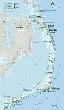
Hatteras Inlet
This article includes a list of general references, but it lacks sufficient corresponding inline citations. (July 2009) |

Hatteras Inlet is an
Ocracoke Island. It connects the Atlantic Ocean to the Pamlico Sound. Hatteras Inlet is located entirely within Hyde County
.
History
The first "Hatteras Inlet" was formed south of the current
forts guarding the inlet quickly fell.[1]
Hatteras Inlet today
The inlet today is approximately two miles across, but this distance changes daily because of the convection of
North Carolina State Highway 12 between the two islands.[2]
Further reading
Claiborne S. Young (2005). Cruising Guide to Coastal North Carolina. Winston-Salem, NC: John F. Blair. ISBN 0-89587-314-1.
Map
References
- ^ "History of Hatteras Inlet". Archived from the original on 2007-02-20. Retrieved 2007-02-12.
- ^ "Hatteras Inlet". OuterBanks.com. Retrieved 2022-08-23.
