
Cape Lookout National Seashore
| Cape Lookout National Seashore | |
|---|---|
IUCN category V (protected landscape/seascape) | |
 Cape Lookout Lighthouse | |
  | |
| Location | Outer Banks, Carteret County, North Carolina, United States |
| Nearest city | Harkers Island, NC |
| Coordinates | 34°36′19″N 76°32′11″W / 34.60528°N 76.53639°W |
| Area | 28,243 acres (114.30 km2)[1] |
| Established | March 10, 1966 |
| Visitors | 541,533 (in 2022)[2] |
| Governing body | National Park Service |
| Website | Cape Lookout National Seashore |
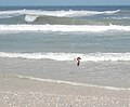
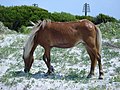
Cape Lookout National Seashore preserves a 56-mile (90-km) long section of the Southern Outer Banks, or Crystal Coast, of North Carolina, USA, running from Ocracoke Inlet on the northeast to Beaufort Inlet on the southwest. Three undeveloped barrier islands make up the seashore - North and South Core Banks and Shackleford Banks. The seashore includes two historic villages on Core Banks, Shackleford's wild horses, and the Cape Lookout Lighthouse, which has a black-and-white diamond pattern. A visitor center for the seashore is located on Harkers Island.
The National Park Service, as part of their Centennial Initiative celebrating its 100th anniversary in 2016, is planning to rehabilitate the Lighthouse and restore the Cape Lookout and Portsmouth Village Historic Districts.[3]
History
The
Laws
The
Map

Climate
According to the
| Climate data for Core Sound, Cape Lookout National Seashore, NC (1981-2010 Averages) | |||||||||||||
|---|---|---|---|---|---|---|---|---|---|---|---|---|---|
| Month | Jan | Feb | Mar | Apr | May | Jun | Jul | Aug | Sep | Oct | Nov | Dec | Year |
| Mean daily maximum °F (°C) | 52.9 (11.6) |
54.8 (12.7) |
60.4 (15.8) |
67.7 (19.8) |
74.8 (23.8) |
81.6 (27.6) |
84.7 (29.3) |
84.0 (28.9) |
80.4 (26.9) |
72.6 (22.6) |
64.9 (18.3) |
56.4 (13.6) |
69.7 (20.9) |
| Daily mean °F (°C) | 45.4 (7.4) |
47.4 (8.6) |
53.0 (11.7) |
60.6 (15.9) |
68.2 (20.1) |
75.8 (24.3) |
79.3 (26.3) |
78.4 (25.8) |
74.5 (23.6) |
65.5 (18.6) |
57.3 (14.1) |
48.9 (9.4) |
62.9 (17.2) |
| Mean daily minimum °F (°C) | 37.9 (3.3) |
39.9 (4.4) |
45.5 (7.5) |
53.5 (11.9) |
61.6 (16.4) |
70.0 (21.1) |
73.8 (23.2) |
72.8 (22.7) |
68.5 (20.3) |
58.4 (14.7) |
49.7 (9.8) |
41.3 (5.2) |
56.1 (13.4) |
| Average precipitation inches (mm) | 4.62 (117) |
3.60 (91) |
4.51 (115) |
3.42 (87) |
4.00 (102) |
4.20 (107) |
5.93 (151) |
7.30 (185) |
6.35 (161) |
4.62 (117) |
4.04 (103) |
4.06 (103) |
56.65 (1,439) |
| Average relative humidity (%)
|
71.7 | 71.6 | 69.5 | 70.9 | 73.2 | 77.1 | 79.2 | 78.6 | 77.0 | 74.0 | 74.6 | 73.2 | 74.2 |
| Average dew point °F (°C) | 36.8 (2.7) |
38.7 (3.7) |
43.3 (6.3) |
51.1 (10.6) |
59.3 (15.2) |
68.1 (20.1) |
72.3 (22.4) |
71.2 (21.8) |
66.8 (19.3) |
57.0 (13.9) |
49.3 (9.6) |
40.7 (4.8) |
54.6 (12.6) |
| Source: PRISM[6] | |||||||||||||
| Climate data for Cape Hatteras, NC Ocean Water Temperature (53 NE Core Sound) | |||||||||||||
|---|---|---|---|---|---|---|---|---|---|---|---|---|---|
| Month | Jan | Feb | Mar | Apr | May | Jun | Jul | Aug | Sep | Oct | Nov | Dec | Year |
| Daily mean °F (°C) | 49 (9) |
46 (8) |
52 (11) |
59 (15) |
68 (20) |
74 (23) |
78 (26) |
80 (27) |
77 (25) |
70 (21) |
58 (14) |
55 (13) |
64 (18) |
| Source: NOAA[7] | |||||||||||||
Ecology
According to the
Wildlife
-
 Common tern Sterna hirundo driving intruders away from the nest site.
 -
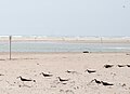 Core Banks
 -
 American oystercatcher Haematopus palliatus
 -
 Brown pelican Pelecanus occidentalis
 -
 Laughing gull Leucophaeus atricilla
 -
 Great egret Ardea alba
 -
 Small shark
 -
 Livelightning whelkSinistrofulgur perversum
 -
 Hermit crab, possiblyflat-clawed hermit crab Pagurus pollicaris in a shell of knobbed whelkBusycon carica
 -
 Shark eye moon snail Neverita duplicata in a shallow water on a sand bar
 -
 Fiddler crab
 -
 Carolina anoleAnolis carolinensis
 -


Bibliography
- The National Parks: Index 2001–2003. Washington: U.S. Department of the Interior.
- Timblin, Carol (September–October 2008). "A World Away: Getting to North Carolina's Cape Lookout National Seashore is getting away from it all". AAA World. side trips. Vol. 10, no. 5. AAA Midatlantic. p. 26. Archived from the original on 2008-10-07. Retrieved 2008-09-04.
Notes
- ^ "Listing of acreage – December 31, 2011" (XLSX). Land Resource Division, National Park Service. Retrieved 2012-12-26. (National Park Service Acreage Reports)
- ^ "NPS Annual Recreation Visits Report". National Park Service. Retrieved October 16, 2023.
- ^ Bomar, Mary A. (August 2007). "Summary of Park Centennial Strategies" (PDF). National Park Service. Retrieved 2008-02-15.
- ^ "H.R. 126 - Summary". United States Congress. Retrieved 5 June 2013.
- ^ "USDA Interactive Plant Hardiness Map". United States Department of Agriculture. Archived from the original on July 4, 2019. Retrieved August 6, 2019.
- ^ "PRISM Climate Group, Oregon State University". Retrieved August 6, 2019.
- ^ "Water Temperature Table of All Coastal Regions". Archived from the original on September 5, 2017. Retrieved August 6, 2019.
- ^ "U.S. Potential Natural Vegetation, Original Kuchler Types, v2.0 (Spatially Adjusted to Correct Geometric Distortions)". Retrieved August 6, 2019.
External links
- Official NPS website: Cape Lookout National Seashore
- Cape Lookout Studies Program
- An entry by the International Dark-Sky Association
| International | |
|---|---|
| National | |