
India–Pakistan border
| India–Pakistan border | |
|---|---|
Shimla Agreement (1972) | |
| Notes | The Line of Control divides Kashmir between India and Pakistan—it is not a part of the internationally recognized section of the border due to the Kashmir conflict |
The India–Pakistan border is the
Arising from the
Sections
.jpg)
The India-Pakistan border includes mutually-recognised International Border and several disputed sections,[6] listed from north to south:
- NJ 9842 and ending in the north on the Indira Ridge at the India-China-Pakistan LAC tripoint near Sia Kangri about 4 km (2.5 mi) northwest of Indira Col West, with peaks in excess of 7,000 m (23,000 ft) and temperatures ranging to around −55 °C (−67 °F).[11][12] India gained control of 1,000 square miles (2,600 km2) of disputed territory in 1984 because of its military operations in Siachen.[6][13]
- Indo-Pakistani War of 1971.[14]
- Working Boundary (WB) - separates the disputed section of Indian-administered Jammu and Kashmir from the Pakistani Punjab: It is referred to as a working boundary by the UN,[15] while India regards it as the international border.[14] Pakistani Punjab is internationally recognized as a part of Pakistan by both parties while Jammu and Kashmir is a disputed territory (claimed by Pakistan, controlled by India).[16][14][15]
- International Boundary (IB) or Radcliffe Line - runs from Punjab to Gujarat and Sindh: The demarcated line between the India and Pakistan is recognized by both nations.
- Sir Creek - separates southern Gujarat in India from southern Sindh in Pakistan:[17] The long-standing India-Pakistan Sir Creek border dispute stems from the demarcation "from the mouth of Sir Creek to the top of Sir Creek, and from the top of Sir Creek eastward to a point on the line designated on the Western Terminus".[17][18] From this point onward, the boundary is unambiguously fixed as defined by the Tribunal Award of 1968.[19]
Barrier
Out of total 3,323 kilometres (2,065 mi) length of border with Pakistan, Government of India has completely fenced 2,064 kilometres (1,283 mi) by 2024 and the remaining 916 kilometres (569 mi) is covered by physical and non-physical barriers as it is not feasible to fence the entire border due to densely forested rugged mountains, riverine and marshy areas. India has similar fence on borders with Bangladesh and Myanmar.[20]
In February 2025, India's Central Public Works Department (CPWD) started to construct a 1,450 km long border road along the border barrier across the Indian Punjab (354 km) and Rajsthan (1096 km). This will enable the swifter access, strengthen the anti-drug and anti-terrorism patrolling, and act as anti-tunnel mechanism.[21]
Border crossings
- Border crossings with designated immigration and customs facilities are:
- Attari and Wagah is the most famous and prominent, due to the Attari–Wagah border ceremony. The crossing is located 32 kilometres from Amritsar and 24 kilometers from Lahore.
- Electronic Travel Authorisation, it has designated immigration and customs facilities.
- Indo-Pakistani War of 1965. It reopened in 2006 but closed again in 2019.[22]
- Other crossings
- Ganda Singh Wala border, Kasur District (Pakistan side) / Hussainiwala border, Punjab (India side)
- Sulaimanki, Punjab (Pakistan side) / Fazilka border, Fazilka district, Punjab (India side)
- Longewala (closed)
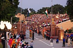
Border ceremonies

At the following border crossing sites and the beating retreat flag ceremonies are jointly held by the military of both nations every day at 6:30 pm, which are open to public as tourist attractions.[23][24] No special permit or ticket is needed. The ceremony sites are as follows (from north to south):
- Punjab, India – Punjab, Pakistan
- Eid and Hindu holiday of Diwali. It has been a peaceful gathering with the exception of the 2014 Wagah border suicide attack by Islamist terrorists in which 60 people were killed and over 110 people were left injured.[27]
- Sadiqui–Sulemanki border ceremony near Fazilka in Punjab.[28][29][30]
- Rajasthan – Sindh
- Munabao–Khokhrapar border ceremony in Barmer district in Rajasthan.[23][24]
Gallery
-
 "Baba Chamliyal Mela" traditional celebration at the India–Pakistan border near Ramgarh, 45 km (28 mi) from Jammu, where both Indians and Pakistanis take part in the festivities.
 -
 EveningWagah–Attari border ceremony, as seen from the Pakistan`s side.
 -
 The floodlit border zone between Pakistan and India seen from outer space.
 -
 Trucks on the former Indian National Highway 1, waiting to cross the border at Wagah–Attari.
 -
 Pakistani Ranger standing guard at the Wagah border crossing.
 -
 Female Indian Border Security Force personnel taking part in the ceremonial retreat at the India–Pakistan border crossing (Wagah–Attari), 2010.
 -
 Map of the India–Pakistan border along theSindh, Pakistan.
 -
 India-Pakistan border at Wagah, 2017
 -
 India gate in Wagah/Attari
 -


See also
- Borders of India
- Borders of Pakistan
- Partition of India
- India–Pakistan relations
- India–Pakistan border skirmishes
- India–Pakistan maritime trespassing
References
- ^ Khan, MH (5 March 2006). "Back on track". Dawn News archives. Retrieved 15 April 2013.
- ^ a b c PBS Release (26 July 2005). "Border Jumpers The World's Most Complex Borders: Pakistan/India". PBS. Retrieved 15 April 2013.
- ^ PHILIP WALKER (24 June 2011). "The World's Most Dangerous Borders". The Foreign Policy. Archived from the original on 24 March 2013. Retrieved 15 April 2013.
- ^ "India-Pakistan Borderlands at Night". India-Pakistan Border at Night. NASA. 23 September 2015. Retrieved 14 October 2015.
- ^ "Annotated image from NASA".
- ^ a b Desmond, Edward W. (31 July 1989). "The Himalayas War at the Top Of the World". Time. Kashmir. Archived from the original on 14 January 2009. Retrieved 11 October 2008.
- ^ The fight for Siachen
- ^ "The endless India-Pakistan sabre-rattling over Siachen glacier and the Line of Control can be resolved by turning the area into a peace park for glacial and weather studies, by B G Verghese, and more from Asian Conversations and Dancing Wolf Media". Archived from the original on 12 April 2015. Retrieved 7 April 2015.
- ^ They shall not pass
- ^ "Bullish on siachen". Archived from the original on 22 February 2014. Retrieved 17 February 2014.
- ^ "Revisiting Siachen after the Ladakh stand-off". 31 August 2020.
- ^ How India realised it was at risk of losing the Siachen glacier to Pakistan, The Print, 12 April 2018.
- ^ Desmond, Edward W. (31 July 1989). "The Himalayas War at the Top Of the World". Time. Archived from the original on 14 January 2009. Retrieved 11 October 2008.
- ^ a b c "Kashmir Fast Facts". CNN. 8 November 2013. Retrieved 20 April 2019.
- ^ a b "Deployment". United Nations Military Observer Group in India and Pakistan. 2 April 2022. Retrieved 2 April 2022.
- ^ "From Line of Control to Working Boundary". Daily Times. 3 March 2018. Retrieved 9 December 2020.
- ^ a b "The troubled waters of Sir Creek: Gujarat CM's demand for a freeze on the disputed creek complicates issue, dated 16 December 2012". India Today. 16 December 2012. Retrieved 29 December 2019.
- ^ "Pakistan security experts declare Sir Creek dispute 'technically resolved'". dna. 7 September 2013.
- ^ "Kargilisation of Sir Creek". The Tribune, Chandigarh. Retrieved 21 May 2006.
- ^ 1643 km Indo-Myanmar border to be fenced, a patrol track to be built: Amit Shah, Hindustan Times, 6 Feb 2024.
- ^ राजस्थान में पश्चिमी सीमा पर बन रहा कुछ ऐसा, जिससे पाकिस्तान के उड़ जाएंगे होश, BSF का काम होगा आसान, MSN.com, 9 Feb 2025.
- ^ hindustantimes.com, Retrieved 21 August 2020
- ^ a b c d 5 crossing points in India: All you need to know, India Today, 10 OCt 2016.
- ^ a b c d Beating Retreat Wagah India, CHanging Guards, accessed 8 July 2021.
- ISSN 0261-3077. Retrieved 19 April 2019.
- ^ a b c Clark, Tawny. "India and Pakistan's beautiful border ritual". www.bbc.com. Retrieved 20 April 2019.
- ^ "Pakistan border bombing kills dozens". 3 November 2014. Retrieved 20 April 2019.
- ^ Sadqi retreat ceremony, nic.in, accessed 8 July 2021.
- ^ Second Wagah: India, Pak agree to new ceremony, beating retreat on Punjab border, Hindustan Times, 201 April 2017.
- ^ At Sadiqi border, strained Indo-Pak ties dampen spirits, The Tribune, 17 April 2019.
External links
 Media related to India-Pakistan border at Wikimedia Commons
- "How this border transformed a subcontinent | India & Pakistan". Vox. 26 June 2019. Archived from the original on 14 December 2021.
- International Boundary Study No. 86 – 2 December 1968 India – Pakistan Boundary
- Last Village in India Pakistan border Whose walls are on the Zero Line