
Ismail County
Județul Ismail | |
|---|---|
County (Județ) | |
|
UTC+3 (EEST ) |
Ismail County was a county (
Geography
The county was located in the eastern part of Greater Romania, in the south of the historical region of Bessarabia, north of the Chilia branch of the Danube.
The county neighboured the counties of
Administration
The county comprised four districts (plăși):[2]
- Plasa Bolgrad, headquartered at Bolgrad
- Plasa Chilia Nouă, headquartered at Chilia Nouă
- Plasa Fântâna Zânelor, headquartered at Fântâna-Zânelor
- Plasa Reni, headquartered at Reni
There were five cities in the county:
Population
According to the Romanian census of 1930 the population of Ismail County was 225,509, of which 31.9% were ethnic Romanians, 29.7% Russians, 19.2% Bulgarians, 6.9% Gagauz, 4.7% Ukrainians, 2.8% Jews, as well as other minorities. From the religious point of view, the county population consisted of 87.9% Eastern Orthodox, 7.6% Old Rite Orthodox (Lipoveni), 2.9% Jewish, as well as other minorities.
Urban population
According to the Romanian census of 1930 the urban population of Ismail County was 75,860, of which 44.7% were ethnic Russians, 24.6% Romanians, 12.4% Bulgarians, 8.1% Jews, 5.0% Ukrainians, 0.7% Greeks, as well as other minorities. From the religious point of view, the urban population consisted of 80.7% Eastern Orthodox, 9.3% Old Rite Orthodox (Lipoveni), 8.2% Jewish, 0.7% Roman Catholic, as well as other minorities.
History
At the end of the
After the Union of Bessarabia with Romania in 1918, Ismail County returned to Romania, being formally re-established in 1925.
After the 1938 Administrative and Constitutional Reform, this county merged with the counties of
The county (and the whole of Bessarabia) was occupied by the Soviet Union in 1940 and became part of the Moldavian SSR and the Ukrainian SSR. The area returned to Romanian administration as the Bessarabia Governorate following the Axis invasion of the Soviet Union in July 1941. A military administration was established and the region's Jewish population was either executed on the spot or deported to Transnistria, where further numbers were killed.[3] As the Soviet Union's offensive pushed the Axis powers back, the area again was under Soviet control. On September 12, 1944, Romania signed the Moscow Armistice with the Allies. The Armistice, as well as the subsequent Paris Peace Treaty of 1947, confirmed the Soviet-Romanian border as it was on January 1, 1941.[4][5] The areas of the county, along with the rest of the Moldavian SSR and the Ukrainian SSR, became part of the independent countries of Moldova and Ukraine, respectively.
Gallery
-
 Ismail County as part of the Principality of Romania (1864–1878)
 -
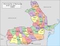
 Map of Ismail County as constituted in 1925
 -
 Map of Ismail County as of 1938
 -
 Ethnic map of Ismail County per the 1930 census

.jpg)


References
- ^ (in Romanian) Memoria.ro, Map of Ismail County, accessed on February 20, 2012
- ^ (in Romanian) Memoria.ro, Administrative Divisions of Ismail County, accessed on February 20, 2012
- ISBN 9780313274978.
- ^ "The Avalon Project: The Armistice Agreement with Rumania; September 12, 1944". avalon.law.yale.edu. Retrieved 17 March 2018.
- ^ United States Department of State. Foreign relations of the United States, 1946. Paris Peace Conference: documents Volume IV (1946)
External links
- (in Romanian) Ismail County on memoria.ro
