
Karkala
This article has multiple issues. Please help improve it or discuss these issues on the talk page. (Learn how and when to remove these template messages)
|
Karkala
Karla | |
|---|---|
Town | |
UTC+5:30 (IST) | |
| PIN | 574 104 |
| Telephone code | 91-(0)8258 |
| Vehicle registration | KA-20 |
| Sex ratio | 1.11 ♂/♀ |
| Website | www |
Karkala, also known as Karla in
.Etymology
Black granite is abundant in the area, and used widely in the local architecture. Hence, the name of the town is derived from kari-kal, meaning black stone. There is still a place called as Kariya Kall in the city which means 'Black Rock' in
History
This article needs additional citations for verification. (July 2023) |
Karkala dates back to the beginning of the 10th century.The town was called Pandya Nagari during the period of

The Alupas were the first to rule the region, and their rule was followed by the Santaras, who were the feudatories of Alupas for many years. The town attained political and cultural importance from the time of the Kalasa-Karkala kingdom that was established by King Bhairava between 13th and 16th centuries.
The royal family of Karkala rose to prominence from the time of the rule of the
King Veera Bhairava,constructed the
King Veera Pandya, at the insistence of his Guru Lalitakeerti, the pontiff of Karkala Jaina Math, installed a large statue of Bahubali on the rocky hill of Karkala. The date of the installation has been ascertained as 13 February 1432. He also installed the Brahmadeva Pillar in front of the statue in 1436. His successor, Abinava Pandya installed a carving of manastambha in front of the Neminatha
Abhinava Pandya's successor was Pandya VI, who is attributed to the construction of the Kere
There are 18
After the rule of the Pandyas, the region was annexed by
Landmarks
Karkala is an important pilgrimage location for Jains. There are several

Karla has famous educational institutions like NITTE College, Shri Bhuvenendra College, Christ king Educational institutions, and Jnanasuda Educational College.

ASI protected sites[1] in Karkala are
- Ananthapadmanabha Temple, Ananthashayana
- Chaturmukha Basadi
- Gommateshwara Statue
- Manasthamba
- Hiriyangadi
- Sri Venkataramana Temple, Karkala
- St. Lawrence Shrine
- Parashurama Theme Park, Karkala
Geography
Karla is located at 13°12′N 74°59′E / 13.2°N 74.98°E.[2] It has an average elevation of 81 metres (265 feet).

It has large number of picturesque lakes. such as Ramasamudra Lake, Kamala Kere, NagarBavi, Anekere, Sigadi Kere, Matadha Kere, Shivathi Kere and Jogina Kere. Situated at the foothills of the Western Ghats, Karkala has an undulating landscape, dotted with black granite outcrops, while the western part of the town is predominantly coastal plains that stretch about 25 km west towards the Arabian Sea.
Meteorological Details

| Climate data for Karkala, India (Karkala) | |||||||||||||
|---|---|---|---|---|---|---|---|---|---|---|---|---|---|
| Month | Jan | Feb | Mar | Apr | May | Jun | Jul | Aug | Sep | Oct | Nov | Dec | Year |
| Record high °C (°F) | 38 (100) |
38 (100) |
42 (108) |
41 (106) |
41 (106) |
37 (99) |
32 (90) |
33 (91) |
33 (91) |
36 (97) |
35 (95) |
35 (95) |
41 (106) |
| Mean daily maximum °C (°F) | 31 (88) |
33 (91) |
34 (93) |
34 (93) |
34 (93) |
30 (86) |
28 (82) |
28 (82) |
30 (86) |
30 (86) |
31 (88) |
30 (86) |
34 (93) |
| Mean daily minimum °C (°F) | 22 (72) |
24 (75) |
26 (79) |
28 (82) |
28 (82) |
27 (81) |
26 (79) |
25 (77) |
25 (77) |
25 (77) |
24 (75) |
22 (72) |
22 (72) |
| Record low °C (°F) | 17 (63) |
16 (61) |
19 (66) |
23 (73) |
23 (73) |
23 (73) |
23 (73) |
23 (73) |
20 (68) |
20 (68) |
18 (64) |
17 (63) |
16 (61) |
| Average rainfall mm (inches) | 9 (0.4) |
9 (0.4) |
19 (0.7) |
39 (1.5) |
99 (3.9) |
663 (26.1) |
629 (24.8) |
288 (11.3) |
153 (6.0) |
133 (5.2) |
57 (2.2) |
19 (0.7) |
2,117 (83.3) |
| Source: MSN Weather
| |||||||||||||
Demographics
As of 2001[update] India
Hinduism is the largest religion in Karkala, with
Culture and Tradition
The people of Karkala follow the
The most popular local sport is
Language
Karkala is a multilingual town.
Administration and Transportation
Being a part of Udupi district, Karkala is in the Udupi-Chikkamagalur Lok Sabha Constituency.The Karkala Town Municipal Council (ಕಾರ್ಕಳ ಪುರಸಭೆ) is the municipal corporation of the town, responsible for all public works and development.
Roadways are the main mode of transportation in Karkala. The town is well connected to Udupi, Moodabidri and Padubidri, and to Sringeri and Kalasa on the Western Ghats. The main roadways serving Karkala are: National Highway NH 169 (Solapur—Mangalore ) Karnataka State Highway SH 1 (Karkala-Padubidri) which connects to National Highway 66 at Padubidri Karnataka State Highway SH 37 (Karkala-Bailur-Manipal-Udupi) Karnataka State Highway SH 1 (Karkala-Hebri)
The nearest railhead is at Udupi while the airport closest to Karkala is at Bajpe in Mangalore. There is an extensive public transport system connecting Karkala to Udupi and Mangalore.
Photo Gallery
-
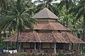
 Ananthapadmanabha Temple, Karla
 -
 Chaturmukha Basadi
 -
 Padmavati Basadi
 -
 Gururaya basadi, Karkala
 -
 Anekere Basadi at the center of pond in Karla
 -
 Veeramaruthi Temple, Karla
 -
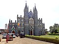 St lawrence Church, Karla
 -
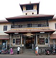 Venkataramana Temple, Karla
 -
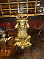 The Deepadhaari at Venkataramana Temple, Karla


.jpg)


See also
- Bedra
- Kere Basadi
- Mangalore
- Shravanabelagola
- Kukke Subramanya Temple
- Dharmasthala
- Siddakatte
- Horanadu
- Sringeri
- Udupi Krishna Temple
- Perdoor
- Mundkur
- Kanthavara
- Jain Bunt
References
- ^ ASI Bengaluru Circle - Udupi district
- ^ Falling Rain Genomics, Inc - Karkal
- ^ "Census of India 2001: Data from the 2001 Census, including cities, villages and towns (Provisional)". Census Commission of India. Archived from the original on 16 June 2004. Retrieved 1 November 2008.
- ^ South Kanara District Gazetteer 1973, p. 93
Works cited
- "People" (PDF). South Kanara District Gazetteer. Karnataka State Gazetteer. Vol. 12. Gazetteer Department (Government of Karnataka). 1973. pp. 86–125. Archived from the original (PDF) on 25 March 2009. Retrieved 26 October 2008.
External links
- About Karkala
- Mahamastakabhisheka
- All about The Mahamastakabhisheka of Lord Bahubali at Karkala, 21-31 January 2015
- All about Karkala
- Info about Padutirupathi
- News Topic about Karkala
- St. Lawrence Church, Attur, Karkala Archived 15 January 2012 at the Wayback Machine
- Shree Venkataramana Temple (Kannada Website) Archived 22 January 2019 at the Wayback Machine
- Shree Venkataramana Temple (English Website)
| International | |
|---|---|
| National | |