Kasai, Hyōgo
Kasai
加西市 | |
|---|---|
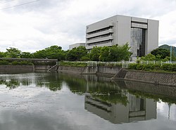
 Kasai City Hall | |
 Location of Kasai in Hyōgo Prefecture | |
 | |
| Coordinates: 34°56′N 134°50′E / 34.933°N 134.833°E | |
| Country | Japan |
| Region | Kansai |
| Prefecture | Hyōgo |
| Government | |
| • Mayor | Kazuhira Nishimura (since June 2011) |
| Area | |
• Total | 150.98 km2 (58.29 sq mi) |
| Population (April 30, 2022) | |
• Total | 42,494 |
| • Density | 280/km2 (730/sq mi) |
| Time zone | UTC+09:00 (JST) |
| City hall address | 1000 Yokoo, Hōjō-chō, Kasai-shi, Hyōgo-ken 675-2395 |
| Website | Official website |
| Symbols | |
| Flower | Salvia |
| Tree | Live oak |

Kasai (加西市, Kasai-shi) is a city located in Hyōgo Prefecture, Japan. As of 30 April 2022[update], the city had an estimated population of 42,494 in 18242 households and a population density of 72 persons per km2.[1] The total area of the city is 150.98 square kilometres (58.29 sq mi).
Geography
Kasai is located almost in the center of the Harima Plain, with forests in the north and low mountains in the south. The city measures approximately 12.4 kilometers east–west, and 19.8 kilometers north–south. The main rivers that flow here are the Manganji River, which is one of the tributaries of the Kako River, and the Fukkoji River, which is a tributary of the Manganji River.
Neighbouring municipalities
Hyōgo Prefecture
Climate
Kasai has a Humid subtropical climate (Köppen Cfa) characterized by warm summers and cool winters with light to no snowfall. The average annual temperature in Kasai is 14.9 °C. The average annual rainfall is 1606 mm with September as the wettest month. The temperatures are highest on average in August, at around 26.8 °C, and lowest in January, at around 3.5 °C.[2]
Demographics
Per Japanese census data,[3] the population of Kasai has remained relatively steady over the past 70 years.
| Year | Pop. | ±% |
|---|---|---|
| 1920 | 39,586 | — |
| 1930 | 39,061 | −1.3% |
| 1940 | 38,642 | −1.1% |
| 1950 | 49,474 | +28.0% |
| 1960 | 49,234 | −0.5% |
| 1970 | 48,354 | −1.8% |
| 1980 | 51,051 | +5.6% |
| 1990 | 51,784 | +1.4% |
| 2000 | 51,104 | −1.3% |
| 2010 | 48,022 | −6.0% |
History
The area of the modern city of Kasai was within ancient
Government
Kasai has a
Economy
The economy of Kasai is centered around agriculture.
Education
Kasai has 11 public elementary schools and four public middle schools operated by the city government and two public high school operated by the Hyōgo Prefectural Department of Education. The prefecture also operates one special education school for the handicapped.
Transportation
Railway
![]() Hōjō Railway Company – Hōjō Line
Hōjō Railway Company – Hōjō Line
- Abiki - Tahara - Hokkeguchi - Harima-Shimosato - Osa - Harima-Yokota - Hōjōmachi
Highway
Public transport
Kasai is highly dependent on private vehicles as the main form of transportation. Public transport is an inter-prefecture highway bus, inter-city bus (Shinki bus), KIX airport limousine bus (Hakuro bus), domestic-bus (Kasai city community bus, Happy bus) and Taxi.
Sister cities
Local attractions
- National Treasure of Japan
- Hyōgo Prefectural Flower Center
- Maruyama Park, where one can find the world's largest globe clock (Guinness certified) and reputedly the world's longest roller slide[citation needed]
- Rakan-ji, famous for its Gohyaku-Rakan statues (the 500 disciples of Buddha)
- Tamaoka Kofun Cluster, National Historic Site
Noted people from Kasai
- Kiichi Inoue, politician
- Shiro Miya, musician
References
- ^ "Kasai city official statistics" (in Japanese). Japan.
- ^ Kasai climate data
- ^ Kasai population statistics
External links
 Media related to Kasai, Hyōgo at Wikimedia Commons
- Kasai City official website (in Japanese)
 Geographic data related to Kasai, Hyōgo at OpenStreetMap


