
Kattegat
| Kattegat | |
|---|---|
| Kattegatt | |
 Map of the Kattegat and Skagerrak | |
 Kattegat | |
| Coordinates | 56°30′N 11°30′E / 56.500°N 11.500°E |
| Etymology | lit. '"cat's gate"' |
| Basin countries | Denmark, Sweden |
| Surface area | 30,000 km2 (12,000 sq mi) |
The Kattegat (Danish:
The Kattegat is a rather shallow sea and can be very difficult and dangerous to navigate because of the many sandy and stony reefs and tricky currents, which often shift. In modern times, artificial seabed channels have been dug, many reefs have been dredged by either sand pumping or stone fishing,[clarification needed] and a well-developed light signaling network has been installed to safeguard the very heavy international traffic on this small sea.
There are several large cities and major ports on the Kattegat, including, in descending size, Gothenburg, Aarhus, Aalborg, Halmstad, and Frederikshavn.
Geography
According to the definition established in a 1932 convention signed by Denmark,
Major
The main islands of the Kattegat are Samsø, Læsø and Anholt; the latter two are, due to their relatively dry climate, perceived as belonging to "the Danish desert belt".
A number of noteworthy coastal areas abut the Kattegat, including the
Since the 1950s, a bridge project usually referred to as Kattegatbroen (the
Extent
The International Hydrographic Organization defines the limits of the "Kattegat, Sound and Belts" (that is, the Kattegat, Øresund, Great Belt, and Little Belt) as follows:[4]
On the North: A line joining Skagen (The Skaw, northernmost point of Denmark) and Paternoster Skær (57°54′N 11°27′E / 57.900°N 11.450°E) and thence northeastward through the shoals to Tjörn Island.
On the South: The limits of the Baltic Sea in the Belts and Sound:
- In the Little Belt: A line joining Falshöft (54°47′N 9°57.5′E / 54.783°N 9.9583°E) and Vejsnæs Nakke (Ærö: 54°49′N 10°26′E / 54.817°N 10.433°E).
- In the Great Belt: A line joining Gulstav (Southernmost extremity of Langeland Island, 54°43′36″N 10°42′42″E / 54.72667°N 10.71167°E) and Kappel Kirke (54°46′N 11°01′E / 54.767°N 11.017°E) on the island of Laaland.
- In the Guldborg Sund : A line joining Flinthorne-Rev (54°38′30″N 11°49′16″E / 54.64167°N 11.82111°E) and Skelby (54°38′00″N 11°53′14″E / 54.63333°N 11.88722°E) ;
- In the Sound: A line joining Stevns Lighthouse (55°17′N 12°27′E / 55.283°N 12.450°E) and Falsterbo Point (55°23′N 12°49′E / 55.383°N 12.817°E).
Etymology
According to
An archaic name for both the
History
Control of the Kattegat, and access to it, have been important throughout the history of international seafaring. Until the completion of the Eider Canal in 1784, the Kattegat was the only sea route into and out of the Baltic region.[8]
Beginning in 1429 in the
Biology
In the Kattegat, the
Ecological collapse
The Kattegat, characterised by widespread
Protections and regulation


Due to the very heavy sea traffic and many large coastal settlements, the Kattegat has been designated as a
Several larger areas of the Kattegat are designated as Natura 2000 and under various bird protections such as the Ramsar Convention. The remaining larger shallow reefs are among the protections, as they are important spawning and feeding grounds for fish and marine mammals and they support a thriving but threatened biodiversity. Protected areas includes:
Denmark[21]
- Grenen
- The Bay of Aalborg, comprising a 1,774 km2 (685 sq mi) shallow sea area.
- Beach meadows on Læsø and the stony reefs south of the island
- Anholt and the sea north of the island.
Sweden[22]
- The Nordre älv estuarynorth of Gothenburg. An important spot for migratory birds and fish.
- The Archipelago of Gothenburg. An important reproduction area for seabirds and seals.
- Kungsbacka Fjord. A shallow water fjord between Gothenburg and Varberg, including important salt marshes.
- Hovs Hallar
- Kullaberg Nature Reserve
Gallery
-
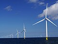 There are several offshorewindfarmsin the Kattegat.
 -
 Some of the world's busiest shipping lanes pass through the Kattegat.
 -
 The larger shallow sand and stony reefs have been equipped with light signaling in modern times.
 -
 There are several small archipelagos near the mainland in the Swedish part of the Kattegat.
 -
 The Swedish coasts in the Kattegat are rocky shores, like this one in Kullaberg, or sandy or gravel beaches.
 -
 All the Danish coasts in the Kattegat are sandy or gravel beaches with no exposed bedrock.

.2.ajb.jpg)


See also
References
- ^ Convention No 3210. League of Nations Treaty Series 139, 1933–1934. Retrieved 27 December 2012.
- ^ Rolf Ask Clausen (2 October 2007). "Ingeniøren 1955: Byg bro over Samsø [Build a bridge across Samsø]". Ingeniøren (in Danish). Retrieved 16 February 2016.
- ^ "En fast Kattegatforbindelse". kattegatforbindelse.dk (in Danish). Kattegatkomitéen. Retrieved 15 May 2017.
- ^ "Limits of Oceans and Seas" (PDF) (3rd ed.). International Hydrographic Organization. 1953. Archived from the original (PDF) on 8 October 2011. Retrieved 28 December 2020.
- ^ Den Store Danske Encyklopædi (2004), CD-ROM edition, Copenhagen: Gyldendal, entry Kattegat.
- ^ a b Nudansk Ordbog (1993), 15th edition, 2nd reprint, Copenhagen: Politikens Forlag, entry Kattegat.
- New International Encyclopedia(1st ed.). New York: Dodd, Mead.
- ^ "Kattegat | strait, Denmark-Sweden". Encyclopedia Britannica. Retrieved 16 May 2017.
- ^ Ærtebjerg, G., Andersen, J.H. and Schou Hansen (2003). "Hydrography". Nutrients and Eutrophication in Danish Seawaters. Danish Environmental Protection Agency and National Environmental Research Institute. Retrieved 30 January 2016.
{{cite web}}: CS1 maint: multiple names: authors list (link) - ISBN 9783540797036. Retrieved 30 January 2016.
- ^ .
- ^ a b c "Red List – Submarine structures made by leaking gases" (PDF). HELCOM. 2013. Retrieved 16 June 2017.
- ^ "Proposed measures for fisheries management in Natura 2000-sites in the Danish territorial area of the Kattegat and Samsø Belt" (PDF). Meeting at the AgriFish Agency, Copenhagen. Minister for Food, Agriculture and Fisheries (Denmark). 20 March 2012. Retrieved 16 June 2017.
- . Retrieved 10 August 2023.
- UNEP. 19 October 2006. Archived from the originalon 4 October 2009. Retrieved 30 January 2016.
- ISBN 978-1285402222.
- ISBN 978-0-87590-266-1.
- ^ Implementation of the Nitrates directive in Denmark Archived 3 December 2013 at the Wayback Machine Danish Ministry of the Environment
- ^ Jesper H. Andersen; Jacob Carstensen (25 October 2011). "Action Plans for the Aquatic Environment have been a success". Politiken (in Danish). Retrieved 24 November 2014.
- ^ "New sulphur regulations may lead to distortion of competition in the shipping industry". MT Online. 12 August 2014. Archived from the original on 26 January 2016. Retrieved 19 January 2016.
- ^ "Natura 2000" (in Danish). Danish Nature Agency. Archived from the original on 10 February 2016. Retrieved 19 January 2016.
- ^ "Natura 2000" (in Swedish). Swedish Environmental Protection Agency. Archived from the original on 26 January 2016. Retrieved 19 January 2016.
External links
- . Encyclopedia Americana. 1920.
- . Collier's New Encyclopedia. 1921.
| International | |
|---|---|
| National | |