
La Tremblade
La Tremblade | |
|---|---|
 The port of La Tremblade | |
 Coat of arms | |
Location of La Tremblade  | |
 La Tremblade  La Tremblade | |
| Coordinates: 45°46′10″N 1°08′30″W / 45.7694°N 1.1417°W | |
| Country | France |
| Region | Nouvelle-Aquitaine |
| Department | Charente-Maritime |
| Arrondissement | Rochefort |
| Canton | La Tremblade |
| Intercommunality | CA Royan Atlantique |
| Government | |
| • Mayor (2020–2026) | Laurence Osta Amigo[1] |
| Area 1 | 69.13 km2 (26.69 sq mi) |
| Population (2021)[2] | 4,436 |
| • Density | 64/km2 (170/sq mi) |
| Time zone | UTC+01:00 (CET) |
| • Summer (DST) | UTC+02:00 (CEST) |
| INSEE/Postal code | 17452 /17390 |
| Elevation | 0–56 m (0–184 ft) |
| 1 French Land Register data, which excludes lakes, ponds, glaciers > 1 km2 (0.386 sq mi or 247 acres) and river estuaries. | |
La Tremblade (French pronunciation: [la tʁɑ̃blad]) is a commune in the Charente-Maritime department and Nouvelle-Aquitaine region of southwestern France.
Toponymy
The name of the town probably derives from the presence of aspen trees (French: tremblers) in the forests of the region during the Middle Ages[3]
Environment

Perfumed by the smell of resin, the forest is in spring all fragrant with the scent of broom and gorse whose bright yellow form with green trees a symphony of colors. What a charming hiking, tasting long solitary walks than winning Ronce-les-Bains by La Coubre forest, Louis Desgraves, Saintonge.
La Tremblade consists of 78% forest and semi-natural areas (forest of La Coubre essentially), with the rest of the territory being divided between wetlands (9%), agricultural land (6%) and artificialized (6%).

Bastion of Protestantism
In the 16th century,
The authorities reacted inconsistently. There were periods of relative tolerance and successive waves of persecution. Philibert Hamelin was arrested in 1557, strangled and burned. During the
In the 17th century and 18th century, La Tremblade 's port was a hub for the provisioning of ships bound for
Oyster farming was established in 1650 by Charles and Blanche Chapeleine. Green oysters from the Isles of Arvert became a delicacy. Eaten raw or marinated, they were prized by King
An order in 1681 to close Protestant temples (churches) opened the way for further persecution of Protestants. Solemn processions were held in the presence of local officials (and the Intendant of Aunis, that same year). The faithful of the "RPR" (
Development
In the 18th century, due to a reversal of the demographic trend, the village, which was not even a full-fledged parish, had a larger population than the capital of the Barony on which it depended,
_LTB3.jpg)
During the 19th century, the city gained a church, temple, covered market and railway, and became an important economic centre of the department. The oyster revolutionised the local economy based on fishing, agriculture (production of wheat, maize and rye), wine (white wine production, brandy and vinegar) and it was also turning more and more towards tourism. In 1876, La Tremblade was classified as the fifth-largest port in France after La Rochelle, with an estimated traffic of 8300 tonnes (oysters, salt, fish products ).[6]

Many villas were built on the edge of the ocean, west of the town, in a grid pattern established by Joseph Edward Perraudeau of Beaufief, one of the first being the Villa "Stork", built in 1860, the genesis of the future seaside district of Ronce-les-Bains.[7] In 1862, a Parisian physician, Dr. Brochard, publishes a brochure entitled The sea baths in La Tremblade contributing to the development of the resort.
In 1940, the city was occupied by German troops. During their withdrawal in February 1945, they burned the city centre, before retreating to a redoubt in the forest of Coubre. The Allies (158th Infantry Regiment) landed at the Mus-de-loup on 14 April 1945 and liberated the city,


Lighthouse


Several temporary lighthouses were established during the 19th century, all undermined by the sea. An imperial decree of 12 May 1860 ordered the establishment of a lighthouse on the north bank of the Gironde estuary, because of the many shipwrecks, although it was not until 1895 that a stone lighthouse 57 metres high was erected. The building collapsed in May 1907 due to erosion by the sea.
The La Coubre Lighthouse, whose construction was decided in October 1904, was commissioned in 1905. Purposely built 1800 meters from the shore, the rapid erosion of the sandbanks in the estuary meant that by 2010 it was only 150 meters from the high-tide mark. It has many cracks and leaks.

It was decorated for the celebration of its centenary in 2005, and included a display tracing the history of lighthouses in the
-
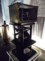
 La Coubre lighthouse museum.
 -

-

-


Economy
The geographical location of the municipality is responsible for the balance of two economic sectors, tourism (mostly coastal) and oyster farming.
Its coastline, its some twenty kilometres of beach, a protected forest area and its proximity to the beach resorts of La Côte de beauté (
The position of the town in the heart of the oyster basin of Marennes fact that production and refining oysters are an important part of the economy, agriculture and oyster gathering 17.7% of assets (more than average county, established at 15.2%).[9] In fact, La Tremblade is not only the first port of Marennes-Oléron basin, but also the whole of France. This privileged position explains a research center of the IFREMER (French Research Institute for Exploitation of the Sea) is located in the town: it is responsible for conducting research on the marine environment of bringing a track in the development of oysters, to preserve the health of livestock but also to work on genetic improvements.[10]
Sport

La Tremblade organise every year since 2001 the Supercross Tremblade , a test of the SX Tour, European competition motocross "freestyle" of international level. The municipality has also provided a framework for cutting multiglisse France in 2008, organized by the French Federation of Surf. Five disciplines were on the program of this national level competition (surfing, longboard, bodyboard, bodysurfing and stand up paddle). In May 2010, France Championships qualification surf casting took place on the beach of Embellie. The wild coast is home to several famous surfing spots, including here, at La Pointe de la Coubre.
On 25 and 26 April 2015, the spot 46 of the wild coast hosts the first step in surfing France cut (longboard categories and stand up paddle). Smaller surf competitions are organized occasionally, mainly at the spot of La Pointe de la Coubre.
Population
|
| ||||||||||||||||||||||||||||||||||||||||||||||||||||||
| Source: EHESS[11] and INSEE (1968-2017)[12] | |||||||||||||||||||||||||||||||||||||||||||||||||||||||
See also
References
- ^ "Répertoire national des élus: les maires" (in French). data.gouv.fr, Plateforme ouverte des données publiques françaises. 13 September 2022.
- ^ "Populations légales 2021". The National Institute of Statistics and Economic Studies. 28 December 2023.
- ^ Heritage of Commons of the Charente-Maritime, Flohr editions, p. 1148
- ^ History of the Reformed Churches of Pons, Gemozac and Mortagne in Saintonge, Alexandre Cesar Crottet, pp. 18–21
- ^ Museum Heritage royannais country
- ^ Tremblade-Ronce-les-Bains, historical Archived 2010-09-26 at the Wayback Machine
- ^ The common heritage of Charente-Maritime, Flohr editions, p.1148
- ^ casinos.org
- ^ Comparateur de territoire, Insee
- ^ Station Ifremer de La Tremblade
- ^ Des villages de Cassini aux communes d'aujourd'hui: Commune data sheet La Tremblade, EHESS (in French).
- ^ Population en historique depuis 1968, INSEE
External links
 Media related to La Tremblade at Wikimedia Commons
| International | |
|---|---|
| National | |