Saint-Rogatien
You can help expand this article with text translated from the corresponding article in French. (December 2008) Click [show] for important translation instructions.
|
Saint-Rogatien | |
|---|---|
 The town hall of Saint-Rogatien | |
| Coordinates: 46°09′08″N 1°04′15″W / 46.1522°N 1.0708°W | |
| Country | France |
| Region | Nouvelle-Aquitaine |
| Department | Charente-Maritime |
| Arrondissement | La Rochelle |
| Canton | La Jarrie |
| Intercommunality | CA La Rochelle |
| Government | |
| • Mayor (2020–2026) | Didier Larelle[1] |
| Area 1 | 5.19 km2 (2.00 sq mi) |
| Population (2021)[2] | 2,408 |
| • Density | 460/km2 (1,200/sq mi) |
| Time zone | UTC+01:00 (CET) |
| • Summer (DST) | UTC+02:00 (CEST) |
| INSEE/Postal code | 17391 /17220 |
| Elevation | 9–33 m (30–108 ft) (avg. 16 m or 52 ft) |
| 1 French Land Register data, which excludes lakes, ponds, glaciers > 1 km2 (0.386 sq mi or 247 acres) and river estuaries. | |
Saint-Rogatien (French pronunciation: [sɛ̃ ʁɔɡasjɛ̃]) is a commune in the Charente-Maritime department in the Nouvelle-Aquitaine region in southwestern France.[3]
Besides the town, the town includes the area of Casse-Mortier and part of the village Pommerou, shared with the town of Clavette.
Gallery
-
St Rogatien church
-
Eglise de Saint-Rogatien
-
Memorial stone
-
The Mairie in Saint-Rogatien
Église Saint-Rogatien-Saint-Donatien
medieval but retains its Romanesque portal and a Gothic trefoil recess. The choir stalls were rebuilt in large part to the late Middle Ages. A granite tithe measure from the fifteenth or sixteenth century, is used as the church font. In 1871, a bell tower
was installed. In 1884, a restoration project was planned but didn't eventuate till 1987, when the facade was restored, the west weakened by weathering.
Population
Its inhabitants are called Rogatiens and Rogatiennes in French.[4]
|
| |||||||||||||||||||||||||||||||||||||||||||||||||||||||||||||||||||||||||||||||||||||||||||||||||||||||||||||||
| Source: EHESS[5] and INSEE[6] | ||||||||||||||||||||||||||||||||||||||||||||||||||||||||||||||||||||||||||||||||||||||||||||||||||||||||||||||||
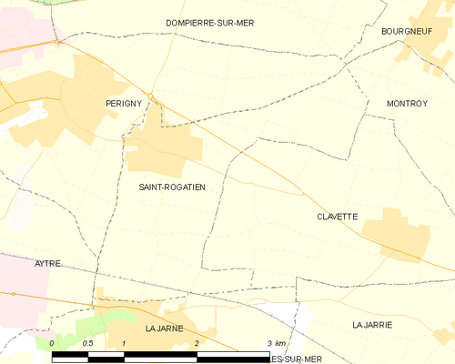
Map of the Commune

See also
- Communes of the Charente-Maritime département
References
- ^ "Répertoire national des élus: les maires" (in French). data.gouv.fr, Plateforme ouverte des données publiques françaises. 13 September 2022.
- ^ "Populations légales 2021". The National Institute of Statistics and Economic Studies. 28 December 2023.
- ^ Commune de Saint-Rogatien (17391), INSEE
- ^ Le nom des habitants du 17 - Charente-Maritime, habitants.fr
- ^ Des villages de Cassini aux communes d'aujourd'hui: Commune data sheet Saint-Rogatien, EHESS (in French).
- ^ Population en historique depuis 1968, INSEE
External links
 Media related to Saint-Rogatien at Wikimedia Commons


