
Lohsa
Lohsa/Łaz | |
|---|---|
 Coat of arms | |
Location of Lohsa/Łaz within Bautzen district 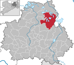 | |
 Lohsa/Łaz  Lohsa/Łaz | |
| Coordinates: 51°23′2″N 14°24′12″E / 51.38389°N 14.40333°E | |
| Country | Germany |
| State | Saxony |
| District | Bautzen |
| Government | |
| • Mayor (2023–30) | Thomas Leberecht[1] (CDU) |
| Area | |
| • Total | 134.36 km2 (51.88 sq mi) |
| Elevation | 114 m (374 ft) |
| Population (2022-12-31)[2] | |
| • Total | 5,145 |
| • Density | 38/km2 (99/sq mi) |
| Time zone | UTC+01:00 (CET) |
| • Summer (DST) | UTC+02:00 (CEST) |
| Postal codes | 02999 |
| Dialling codes | 035724/035726 |
| Vehicle registration | BZ, BIW, HY, KM |
| Website | Einheitsgemeinde Lohsa |
Lohsa (German) or Łaz (Upper Sorbian, pronounced [ˈwas]) is a municipality in the district of Bautzen, in Saxony, in eastern Germany.
The municipality is part of the recognized Sorbian settlement area in Saxony. Upper Sorbian has an official status next to German, all villages bear names in both languages.
Demographics
The Sorbian population of the village was 358 in 1840, 355 in 1860, and 400 in 1880.[3]
Villages
Several villages belong to the municipality (names given in German/Upper Sorbian):
- Dreiweibern/Tři Žony
- Driewitz/Drěwcy
- Friedersdorf/Bjedrichecy
- Groß Särchen/Wulke Ždźary
- Hermsdorf/Spree/Hermanecy
- Koblenz/Koblicy
- Lippen/Lipiny
- Litschen/Złyčin
- Lohsa/Łaz
- Mortka/Mortkow
- Riegel/Roholń
- Steinitz/Šćeńca
- Tiegling/Tyhelc
- Weißig/Wysoka
- Weißkollm/Běły Chołmc
Economy and Infrastructure
Education
The municipality of Lohsa has a primary school in Groß Särchen and a secondary school.
Traffic
To the east of the municipality runs the B 156, to the west the B 96, via which the B 97 to the northwest can be reached. Lohsa is connected to the Niesky-Hoyerswerda(-Falkenberg (Elster)-Roßlau (Elbe)) railway line by a demand stop. The RB 64 line (Hoyerswerda-Görlitz) operates here as Seenland-Neisse-Shuttle.
Notable people
- Handrij Zejler (1804–1872), Sorbian writer and activist, lived and died in Łaz[3]
- Martha Israel (1905–c. 1967), politician[4]
Gallery
-
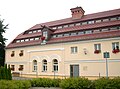 Municipal building
 -
 Church
 -
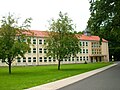 School
 -
 Castle in Weißig/Wysoka


See also
References
- Statistisches Landesamt des Freistaates Sachsen. Retrieved 6 July 2023.
- Statistisches Landesamt des Freistaates Sachsen. 2024.
- ^ a b Słownik geograficzny Królestwa Polskiego i innych krajów słowiańskich, Tom V (in Polish). Warszawa. 1884. p. 616.
{{cite book}}: CS1 maint: location missing publisher (link) - OCLC 277197894.
External links
 Media related to Lohsa at Wikimedia Commons

| International | |
|---|---|
| National | |
| Geographic | |
This Bautzen location article is a stub. You can help Wikipedia by expanding it. |