
Malcesine
This article needs additional citations for verification. (August 2013) |
Malcesine | |
|---|---|
| Comune di Malcesine | |
 | |
|
Coat of arms | |
Location of Malcesine  | |
UTC+2 (CEST) | |
| Postal code | 37018, frazioni 37010 |
| Dialing code | 045 |
| Website | Official website |
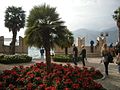
Malcesine is a comune (municipality) on the eastern shore of Lake Garda in the Province of Verona in the Italian region Veneto, located about 120 kilometres (75 miles) northwest of Venice and about 40 kilometres (25 miles) northwest of Verona. It is one of I Borghi più belli d'Italia ("The most beautiful villages of Italy").[3]
Geography and divisions
The comune of Malcesine consists of (from north to south) Navene, Campagnola, Malcesine proper, Val di Sogno and Cassone. It stretches along the Via Gardesana Orientale (Strada Statale 249) and is nestled between Lake Garda and the slopes of
Two of the largest islands of Lake Garda are located in Malcesine: The Isola di sogno and the Isola dell'olivo (or Isola degli olivi).
History
The first recorded inhabitants of the area were
Between the 5th and 6th centuries the Langobards built a castle on the rock where the Castello Scaligero stands today. It was destroyed in 590 by the
In 1797-98, the area was occupied by the forces of
Origins of the name
The first appearance of the toponym dates back to 9 September 844, when the term Manessicelles results in the testament of the Archdeacon Pacific with the meaning, according to Borsatti,[6] of the tombs of the dead: this meaning would be corroborated by the discovery of some Etruscan-style burials in the surroundings up area. Over the centuries there are many documentary variants: Manascicines (932), Malesicine (1023), Malesisicis (1154), Malesisinum (1159), Malasilice (1225), Malsexeno (1422), Malsesene (1611) to name but a few of the Maffezzoli.[7] The etymology of the toponym is however uncertain, revolving around the interpretation of Malae silices or Mala silex as "Stone hostile" or "Bad stone", probably referring to the morphology of the territory characterized by steep mountains rising on the lake, or as "Bad paved road" of Roman origin.[8]
Main sights

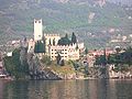
Castello Scaligero
Malcesine's most prominent landmark is the Castello Scaligero, which has 13th-century fortifications and an older medieval tower in white natural stone. Like the castle of
In September 1786,
Today, the castle contains a small museum on the natural history of Lake Garda (Museo del Garda) and Monte Baldo (Museo del Baldo). One room in the Austrian powder magazine is dedicated to Goethe and his visit.[11]
Palazzo dei Capitani
Located on the lake shore is the Palazzo dei Capitani. It was constructed by the Scala family between the 13th and 14th centuries on older
On 20 March 1854, the comune of Verona effectively ceded the property to the comune of Malcesine and in 1897, Malcesine became the sole owner. It has been a national monument since 1902.[12] Today, it is used for exhibitions and events and also houses the public library.
-
 Castello Scaligero, Malcesine.
 -
 Goethe Memorial, Malcesine.
 -
 Garden of the Palazzo dei Capitani, Malcesine.
 -
 Palazzo dei Capitani, Malcesine.


Monte Baldo
Behind Malcesine rises the 2,218 m (7,277 ft) high Monte Baldo. A two-stage cable car ride—the second leg using one with rotating cabins—takes passengers to 1,750 m (5,741 ft)

-
 Cablecar from Malcesine to Monte Baldo. Top Station, ca. 1700m
 -
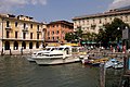 Malcesine harbour.
 -
 Painting of Malcesine harbour by Gustav Klimt, 1913. Destroyed by fire at Schloss Immendorf, 1945.
 -
 Malcesine from the south.


Churches
Pieve di S. Stefano (or parish church of St. Stephen), first mentioned in the 9th century. Today's baroque church dates to the early 18th century and contains several works of art including the altars of SS. Benigno e Caro (Saints Benigno and Caro, 1769) and of the Beata Vergine delle sette allegrezze (Virgin of the Seven Joys, 1771), as well as a tabernacle and the painting Deposizione attributed to Girolamo dai Libri.[14][15]
Santa Maria di Navene is yet another notable church in the town, dating back to the 17th century).[16]
Economy
Transport
Whilst Malcesine is not connected to the railway, the town is served by buses.[17] Moreover, there is public transportation by boat, including express hydrofoils, on the lake for passengers as well as a car ferry.[18][19]
Climate
| Climate data for Malcesine | |||||||||||||
|---|---|---|---|---|---|---|---|---|---|---|---|---|---|
| Month | Jan | Feb | Mar | Apr | May | Jun | Jul | Aug | Sep | Oct | Nov | Dec | Year |
| Mean maximum °C (°F) | 14.4 (57.9) |
15.2 (59.4) |
20.4 (68.7) |
23.0 (73.4) |
27.0 (80.6) |
29.8 (85.6) |
32.0 (89.6) |
31.8 (89.2) |
28.6 (83.5) |
25.4 (77.7) |
18.6 (65.5) |
15.4 (59.7) |
32.0 (89.6) |
| Mean daily maximum °C (°F) | 9.4 (48.9) |
10.8 (51.4) |
13.4 (56.1) |
16.7 (62.1) |
21.3 (70.3) |
24.8 (76.6) |
28.0 (82.4) |
27.5 (81.5) |
24.0 (75.2) |
19.4 (66.9) |
13.5 (56.3) |
10.0 (50.0) |
18.2 (64.8) |
| Daily mean °C (°F) | 6.7 (44.1) |
7.7 (45.9) |
10.0 (50.0) |
13.0 (55.4) |
17.3 (63.1) |
20.6 (69.1) |
23.7 (74.7) |
23.5 (74.3) |
20.4 (68.7) |
15.8 (60.4) |
10.8 (51.4) |
7.1 (44.8) |
14.7 (58.5) |
| Mean daily minimum °C (°F) | 3.9 (39.0) |
4.6 (40.3) |
6.6 (43.9) |
9.3 (48.7) |
13.3 (55.9) |
16.4 (61.5) |
19.4 (66.9) |
19.4 (66.9) |
16.8 (62.2) |
12.2 (54.0) |
8.0 (46.4) |
4.1 (39.4) |
11.2 (52.2) |
| Mean minimum °C (°F) | −1.0 (30.2) |
0.0 (32.0) |
2.2 (36.0) |
5.4 (41.7) |
9.4 (48.9) |
11.0 (51.8) |
15.0 (59.0) |
14.8 (58.6) |
11.4 (52.5) |
7.0 (44.6) |
2.4 (36.3) |
−0.4 (31.3) |
−1.0 (30.2) |
| Average precipitation mm (inches) | 43 (1.7) |
44 (1.7) |
45 (1.8) |
48 (1.9) |
62 (2.4) |
84 (3.3) |
56 (2.2) |
82 (3.2) |
39 (1.5) |
34 (1.3) |
86 (3.4) |
30 (1.2) |
653 (25.7) |
| Average precipitation days (≥ 1.0 mm) | 4 | 5 | 5 | 7 | 8 | 9 | 6 | 7 | 6 | 3 | 6 | 3 | 69 |
| Mean monthly sunshine hours | 68.2 | 93.2 | 120.9 | 150.0 | 186.0 | 204.0 | 248.0 | 207.7 | 162.0 | 142.6 | 78.0 | 86.8 | 1,747.4 |
| Mean daily sunshine hours | 2.2 | 3.3 | 3.9 | 5.0 | 6.0 | 6.8 | 8.0 | 6.7 | 5.4 | 4.6 | 2.6 | 2.8 | 4.8 |
| Source: Archivio climatico Enea-Casaccia[20] | |||||||||||||
References
- ^ "Superficie di Comuni Province e Regioni italiane al 9 ottobre 2011". Italian National Institute of Statistics. Retrieved 16 March 2019.
- ^ "Popolazione Residente al 1° Gennaio 2018". Italian National Institute of Statistics. Retrieved 16 March 2019.
- ^ "Veneto" (in Italian). Retrieved 31 July 2023.
- ^ a b c d e "History". Malcesine piu/Comune di Malcesine. Archived from the original on 20 August 2013. Retrieved 18 August 2013.
- ^ a b c d e "Castello Scaligero di Malcesine (Italian/German)" (PDF). Comune di Malcesine. Retrieved 18 August 2013.
- ^ D. G. Borsatti, "Malcesine", La Tipografica Veronese, 1929, p. 26.
- ^ N. Maffezzoli, "Asterischi malcesinesi", Comitato Museo Castelo Scaligero Malcesine, 1990, pp. 9-14.
- ^ G. Trimeloni, "Malcesine, Toponimi E Memorie", Tipografia Andreis, 1999, pp. 108-109.
- ^ Mentzel, Elisabeth (1908). "Auf Goethes Spuren in Malcesine (German/Italian)" (PDF). Comune di Malcesine. Retrieved 18 August 2013.
- ^ "Malcesine: Il castello e il Monte Baldo (Italian)" (PDF). Comune di Malcesine. Retrieved 18 August 2013.
- ^ "The castle of Malcesine". Comune di Malcesine. Archived from the original on 19 August 2013. Retrieved 18 August 2013.
- ^ a b "Il Palazzo dei Capitani (Italian)". Malcesine piu/Comune di Malcesine. Archived from the original on 10 June 2013. Retrieved 18 August 2013.
- ^ "Cableway Malcesine Monte Baldo". Funivia Malcesine Monte Baldo. Retrieved 18 August 2013.
- ^ "Mostra (Italian)" (PDF). Comune di Verona. Retrieved 18 August 2013.
- ^ "L'antica Pieve di S. Stefano di Malcesine (Italian)". Comune di Malcesine. Archived from the original on 4 October 2012. Retrieved 18 August 2013.
- ^ "Chiesa di S. Maria di Navene (Italian)". Comune di Malcesine. Archived from the original on 4 March 2016. Retrieved 18 August 2013.
- ^ "Means of transport (site uses frames)". Malcesine piu/Comune di Malcesine. Archived from the original on 18 July 2013. Retrieved 18 August 2013.
- ^ "Malcesine, Lake Garda, Italy". www.lakegardaholidays.co.uk. Retrieved 30 September 2016.
- ^ "Profilo climatico dell'Italia: Malcesine" (in Italian). Ente per la Nuove tecnologie, l'Energia e l'Ambiente. Retrieved 19 May 2015.
External links
- Town website
- Tourism website
- From Italienische Reise by J.W.Goethe, 13 September 1786 in Malcesine (German)
| Settlements |
|  |
|---|---|---|
| Islands |
| |
| Rivers | ||
| Wines | ||
| People | ||
| International | |
|---|---|
| National | |