Miami Valley

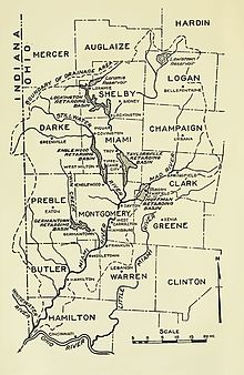
The Miami Valley is the land area surrounding the
Miami Indians.[1]
Commonly, however, it refers to the economic and cultural-social region centered on the
Miami Valley Hospital, Miami Valley Young Marines,[2] Miami Valley Council of the Boy Scouts of America
and Miami Valley Storytellers illustrate local usage.

History
During the mid-twentieth century, among the largest employers in the Valley were
National Cash Register in Dayton.[3]
Counties and cities
Local television stations
WRGT
include the following counties and cities in the cultural Miami Valley:
- Montgomery County (Dayton)
- Greene County (Xenia)
- Preble County (Eaton)
- Clark County (Springfield)
- Miami County (Troy)
- Darke County (Greenville)
- Champaign County (Urbana)
- Shelby County (Sidney)
- Logan County (Bellefontaine)
- Butler and Warren counties (Middletown)
- Wayne County, Indiana (Richmond)
- Mercer County (Celina)
- Auglaize County (Wapakoneta)
Additionally, WHIO includes the following locations in its news and weather coverage:
Transportation
Transit
- Butler County Regional Transit Authority - Primarily serves Hamilton, Middletown and Oxford
- Greater Dayton Regional Transit Authority
- Greene CATS Public Transit - Serves Xenia
- Rose View Transit- Serves Richmond, IN
- Springfield City Area Transit
Major highways
- Interstate 75 - Runs north to south along the valley and through downtown Dayton.
- Interstate 70 - Traverses the valley from east to west.
- Interstate 71 - Runs north to south along the eastern half of the Miami Valley.
- Interstate 675 - Bypasses Dayton from I-75 south of the city to I-70 east of it.
- U.S. Route 35 - Runs east to west through the Dayton metro area.
- U.S. Route 68 - Runs north to south through farmlands in the eastern Miami Valley.
- U.S. Route 127 - Runs north to south through several cities and rural communities in the western Miami Valley.
- Ohio State Route 129 - Connects Hamilton to I-75.
- Ohio State Route 49 - Forms a bypass west of Dayton and continues north into Darke County.
Demographics
As
US Census Bureau could begin reporting the Cincinnati and Dayton metropolitan areas as one by that time, though it would be up to the U.S. Office of Management and Budget to make the merger decision. The new Cincinnati–Dayton metropolitan area would be comparable in size to that of the Orlando–Deltona–Daytona Beach, FL CSA and place it within the top 20 most populous metros in the US, with a population of nearly 3.0 million.[4]
See also
References
- ^ Drury, Augustus Waldo (1909). History of the City of Dayton and Montgomery County, Ohio, Volume 1. S. J. Clarke Publishing Company. p. 57.
- ^ Marines, Miami Valley Young. "Miami Valley Young Marines". Miami Valley Young Marines. Retrieved 2022-07-23.
- ISBN 978-0-06-230054-6.
- ^ A combined Cincinnati-Dayton metropolitan comes closer to reality
Further reading
- Sealander, Judith. Grand Plans: Business Progressivism and Social Change in Ohio's Miami Valley, 1890-1929 (1988) excerpt
