
Minamichita
Minamichita
南知多町 | |
|---|---|
Town | |
 Minamichita Town Hall | |
|
Quercus phillyraeoides (species of Oak ) |
Minamichita (南知多町, Minamichita-chō) is a
Geography
Minamichita is located in the extreme southern tip of
Neighboring municipalities
- Aichi Prefecture
Demographics
Per Japanese census data,[2] the population of Minamichita had been declining steadily over the past 70 years.
| Year | Pop. | ±% |
|---|---|---|
| 1940 | 22,741 | — |
| 1950 | 30,379 | +33.6% |
| 1960 | 28,972 | −4.6% |
| 1970 | 27,705 | −4.4% |
| 1980 | 27,017 | −2.5% |
| 1990 | 25,954 | −3.9% |
| 2000 | 23,250 | −10.4% |
| 2010 | 20,550 | −11.6% |
Climate
The town has a climate characterized by hot and humid summers, and relatively mild winters (Köppen climate classification Cfa). The average annual temperature in Minamichita is 15.7 °C (60.3 °F). The average annual rainfall is 1,550.1 mm (61.03 in) with September as the wettest month. The temperatures are highest on average in August, at around 27.2 °C (81.0 °F), and lowest in January, at around 5.2 °C (41.4 °F).[3]
| Climate data for Minamichita (1991−2020 normals, extremes 1979−present) | |||||||||||||
|---|---|---|---|---|---|---|---|---|---|---|---|---|---|
| Month | Jan | Feb | Mar | Apr | May | Jun | Jul | Aug | Sep | Oct | Nov | Dec | Year |
| Record high °C (°F) | 17.0 (62.6) |
21.0 (69.8) |
24.4 (75.9) |
28.9 (84.0) |
32.7 (90.9) |
34.8 (94.6) |
37.6 (99.7) |
38.3 (100.9) |
36.1 (97.0) |
30.4 (86.7) |
25.6 (78.1) |
23.1 (73.6) |
38.3 (100.9) |
| Mean daily maximum °C (°F) | 9.1 (48.4) |
10.0 (50.0) |
13.5 (56.3) |
18.8 (65.8) |
23.2 (73.8) |
26.1 (79.0) |
30.0 (86.0) |
31.7 (89.1) |
28.0 (82.4) |
22.6 (72.7) |
16.9 (62.4) |
11.6 (52.9) |
20.1 (68.2) |
| Daily mean °C (°F) | 5.2 (41.4) |
5.6 (42.1) |
8.7 (47.7) |
13.7 (56.7) |
18.3 (64.9) |
21.9 (71.4) |
25.8 (78.4) |
27.2 (81.0) |
23.8 (74.8) |
18.3 (64.9) |
12.6 (54.7) |
7.6 (45.7) |
15.7 (60.3) |
| Mean daily minimum °C (°F) | 1.3 (34.3) |
1.4 (34.5) |
4.1 (39.4) |
8.9 (48.0) |
13.9 (57.0) |
18.5 (65.3) |
22.7 (72.9) |
23.8 (74.8) |
20.5 (68.9) |
14.6 (58.3) |
8.5 (47.3) |
3.6 (38.5) |
11.8 (53.3) |
| Record low °C (°F) | −6.5 (20.3) |
−7.3 (18.9) |
−5.2 (22.6) |
−2.7 (27.1) |
2.9 (37.2) |
9.0 (48.2) |
14.6 (58.3) |
14.1 (57.4) |
8.8 (47.8) |
2.7 (36.9) |
−2.4 (27.7) |
−6.0 (21.2) |
−7.3 (18.9) |
| Average precipitation mm (inches) | 54.4 (2.14) |
59.3 (2.33) |
107.7 (4.24) |
122.2 (4.81) |
159.9 (6.30) |
187.7 (7.39) |
167.7 (6.60) |
106.8 (4.20) |
248.7 (9.79) |
201.2 (7.92) |
77.4 (3.05) |
57.2 (2.25) |
1,550.1 (61.03) |
| Average precipitation days (≥ 1.0 mm) | 5.4 | 6.1 | 9.2 | 9.5 | 10.1 | 12.3 | 10.9 | 7.3 | 10.5 | 10.0 | 6.6 | 5.9 | 103.8 |
| Mean monthly sunshine hours | 181.5 | 176.5 | 199.8 | 205.4 | 206.8 | 155.9 | 193.9 | 241.9 | 174.5 | 170.9 | 167.4 | 175.4 | 2,249.9 |
| Source: Japan Meteorological Agency[4][3] | |||||||||||||
History
The area of Minamichita was part of
The modern town of Minamichita was established on June 1, 1961, through the merger of the towns of Utsumi, Mihama, and Morozaki, and the villages of Shinojima and Himakajima, all within Chita District. During March 2006, discussions were held to
Economy
.jpg)
The
The Yamadera kiln (山寺窯) was located in Utsumi, today part of Minamichita. The kiln was active in the years Meiji 40 (1907) - Taishō 3 (1914). It produced Utsumi ware (内海焼).[6][7]
Education
Minamichita has six public elementary schools and five public junior high schools operated by the town government, and one high school operated by the Aichi Prefectural Board of Education.
Transportation
Railway
Highways
Seaports
- Morogizaki Port
Local attractions
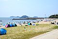
- Minamichita Onsen - hot spring resort
- Himakajima - island in Mikawa Bay
- Shinojima - island in Mikawa Bay
-
 Sightseeing farm Flower garden
 -
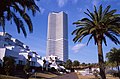 Citta Napoli
 -
 Himakajima
 -
 Shinojima
 -
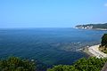 Cape Hazu


References
- ^ Minamichita Town official statistics (in Japanese)
- ^ Minamichita population statistics
- ^ a b 気象庁 / 平年値(年・月ごとの値). JMA. Retrieved April 13, 2022.
- ^ 観測史上1~10位の値(年間を通じての値). JMA. Retrieved April 13, 2022.
- ^ "美浜町の概要". Mihama official home page (in Japanese). Retrieved 28 December 2015.
- ^ "企画展「四代佐七と内海焼」 |TabiChita(タビチタ)|愛知県|知多半島観光圏協議会".
- ^ http://minamichita.ed.jp/kyoikucho/2018/07/16/no-%EF%BC%91%EF%BC%99%EF%BC%93%EF%BC%99%E3%80%80%E3%80%80%E5%86%85%E7%94%B0%E5%AE%B6%E4%BC%81%E7%94%BB%E5%B1%95%E3%80%80%E3%80%8C%E5%9B%9B%E4%BB%A3%E4%BD%90%E4%B8%83%E3%81%A8%E5%86%85%E6%B5%B7/
External links
| Nagoya |
| |||
|---|---|---|---|---|
| Core cities | ||||
| Special city | ||||
| Cities | ||||
| Districts | ||||
| Former Districts | ||||
| International | |
|---|---|
| National | |
| Geographic | |