
Tahara, Aichi
Tahara
田原市 | |
|---|---|
 Upper: Iragomisaki Lighthouse, Cape Iragomi Middle: Tahara Castle, Mt Zao Lookout Lower:Kazan Jinja, Akahane Beach | |
|
Cinnamomum camphora |
Tahara (田原市, Tahara-shi) is a city in Aichi Prefecture, Japan. As of 1 October 2019[update], the city had an estimated population of 60,206 in 22,576 households,[1] and a population density of 315 persons per km2. The total area of the city is 191.12 square kilometres (73.79 sq mi).
Geography

Tahara is situated in southern
Climate
The city has a climate characterized by hot and humid summers, and relatively mild winters (Köppen climate classification Cfa). The average annual temperature in Tahara is 16.4 °C (61.5 °F). The average annual rainfall is 1,642.1 mm (64.65 in) with September as the wettest month. The temperatures are highest on average in August, at around 27.4 °C (81.3 °F), and lowest in January, at around 6.0 °C (42.8 °F).[3]
| Climate data for Cape Irago, Tahara (1991−2020 normals, extremes 1947−present) | |||||||||||||
|---|---|---|---|---|---|---|---|---|---|---|---|---|---|
| Month | Jan | Feb | Mar | Apr | May | Jun | Jul | Aug | Sep | Oct | Nov | Dec | Year |
| Record high °C (°F) | 17.5 (63.5) |
21.4 (70.5) |
24.0 (75.2) |
28.2 (82.8) |
31.3 (88.3) |
36.3 (97.3) |
37.6 (99.7) |
38.4 (101.1) |
35.9 (96.6) |
30.3 (86.5) |
25.2 (77.4) |
23.4 (74.1) |
38.4 (101.1) |
| Mean daily maximum °C (°F) | 9.4 (48.9) |
10.2 (50.4) |
13.7 (56.7) |
18.8 (65.8) |
23.1 (73.6) |
26.0 (78.8) |
30.0 (86.0) |
31.6 (88.9) |
28.1 (82.6) |
22.7 (72.9) |
17.2 (63.0) |
11.9 (53.4) |
20.2 (68.4) |
| Daily mean °C (°F) | 6.0 (42.8) |
6.3 (43.3) |
9.4 (48.9) |
14.3 (57.7) |
18.8 (65.8) |
22.2 (72.0) |
26.1 (79.0) |
27.4 (81.3) |
24.4 (75.9) |
19.1 (66.4) |
13.6 (56.5) |
8.6 (47.5) |
16.3 (61.4) |
| Mean daily minimum °C (°F) | 2.9 (37.2) |
2.9 (37.2) |
5.4 (41.7) |
10.1 (50.2) |
15.0 (59.0) |
19.2 (66.6) |
23.3 (73.9) |
24.5 (76.1) |
21.5 (70.7) |
16.0 (60.8) |
10.1 (50.2) |
5.2 (41.4) |
13.0 (55.4) |
| Record low °C (°F) | −4.4 (24.1) |
−4.0 (24.8) |
−3.0 (26.6) |
1.2 (34.2) |
6.2 (43.2) |
12.1 (53.8) |
15.3 (59.5) |
16.8 (62.2) |
12.3 (54.1) |
6.4 (43.5) |
2.1 (35.8) |
−3.6 (25.5) |
−4.4 (24.1) |
| Average precipitation mm (inches) | 61.9 (2.44) |
68.3 (2.69) |
121.5 (4.78) |
138.8 (5.46) |
163.5 (6.44) |
179.6 (7.07) |
159.6 (6.28) |
115.5 (4.55) |
240.6 (9.47) |
223.9 (8.81) |
106.0 (4.17) |
63.1 (2.48) |
1,642.1 (64.65) |
| Average precipitation days (≥ 1.0 mm) | 5.4 | 5.9 | 8.5 | 9.4 | 9.7 | 11.6 | 9.8 | 6.7 | 10.6 | 10.1 | 6.4 | 5.6 | 99.7 |
| Average relative humidity (%)
|
63 | 63 | 65 | 68 | 73 | 80 | 82 | 79 | 77 | 72 | 69 | 66 | 71 |
| Mean monthly sunshine hours | 180.1 | 176.1 | 201.3 | 201.3 | 205.1 | 155.5 | 194.4 | 234.2 | 169.0 | 164.1 | 166.0 | 174.9 | 2,222 |
| Source: Japan Meteorological Agency[4][3] | |||||||||||||
Demographics
Per Japanese census data,[5] the population of Tahara has been relatively steady over the past 60 years.
| Year | Pop. | ±% |
|---|---|---|
| 1950 | 65,095 | — |
| 1960 | 59,120 | −9.2% |
| 1970 | 56,248 | −4.9% |
| 1980 | 60,581 | +7.7% |
| 1990 | 64,978 | +7.3% |
| 2000 | 65,534 | +0.9% |
| 2010 | 64,128 | −2.1% |
Neighboring municipalities
- Toyohashi
History
Origin
The area of present-day Tahara has been continuously occupied since prehistoric times. Archaeologists have found numerous remains from the Jōmon period and burial mounds from the Kofun period.
Ancient history
During the
Middle Ages
During the Kamakura period, the area was noted for production of a certain type of pottery. During the Sengoku period, the area was under the control of the Toda clan, who constructed Tahara Castle.
Early modern period
The Toda, who were allied with
Late modern period
At the start of the
Contemporary history
Fukue later changed its name to Atsumi Town on April 15, 1955. On November 11, 1958, the village of Akabane was raised to town status.
The city of Tahara was established on August 20, 2003, from the merger the former town of Tahara, absorbing the town of Akabane (both from Atsumi District) to elevate city status. On October 1, 2005, the town of Atsumi (also from Atsumi District) was merged into Tahara. Therefore, Atsumi District was dissolved as a result of this merger.
Government
.jpg)
Tahara has a
External relations
Twin towns – Sister cities
International
- Sister city
 Georgetown (Kentucky, United States of America)
- since April 20, 1990
- Princeton (Indiana, United States of America)
- since August 8, 2002
- Friendship city
 Kunshan (Jiangsu, China)
- since May 14, 1993[6]
- Dongjak-gu (Seoul, South Korea)
- since December 2006[6]
National
Friendship city
 Shitara (Aichi Prefecture, Chūbu region)
- since Marchi 24, 1999
- Miyata (Nagano Prefecture, Chūbu region)
- since November 9, 1999
Economy
Tahara is a regional commercial center with a mixed economy of manufacturing and agriculture. Due to its long coastline, Tahara has many ports for commercial fishing.
Secondary sector of the economy
Manufacturing
The main industrial employer is
models. The Toyota Celica was manufactured in Tahara from 1979 to 1999. Many Lexus models are manufactured within this plant, as are many Toyota models for domestic and international markets.Lifeline
Energy
Tahara has a
Education
Schools
Tahara has 18 public elementary schools, five public middle schools operated by the city government and three public high schools operated by the Aichi Prefectural Board of Education.
Transportation

Railways
Conventional lines
- Atsumi Line: - Yagumadai – Toshima – Kambe – Mikawa Tahara
Bus
Bus services
Toyotetsu buses and city-operated environmentally friendly public transport facilitate access throughout Tahara, even to the westernmost point at
Roads
Japan National Route
 National Route 259 is the main highway that runs the length of Atsumi Peninsula. An alternate reading of the kanji in this highway numeral designation is ji-go-ku. In Japanese, the word jigoku means Hell, and thus some locals refer to it as ji-go-ku-douro, or the "Highway to Hell". This term was encouraged by the perception of a higher fatality rate along the road, especially before it was widened and improved.
 National Route 42
Seaways
Seaports
From the Port of Irago, the
.Local attractions
- shell middenand National Historic Site
- Irago Tōdai-ji Tile Kiln ruins, Kamakura-period kiln ruins, a National Historic Site
- Ōarako Old Kiln ruins, a National Historic Site
- Site of Tahara Castle
- Kojigahama Beach, Cape Irago, the wave sounds of which were listed as one of the 100 Soundscapes of Japan by the Ministry of the Environment[10]
- Kazan Jinja
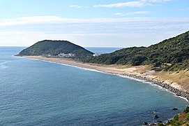
- Akabane Long Beach, also known as "Akabane Beach" or "Long Beach", is a very scenic area for locals and tourists. The Akabane Beach hosted the 2018 World Surfing Games, among other international surfing competitions over the years.
-
-
 View of Cape Irago from Irako View Hotel
 -
 Akabane Long Beach
 -
 Rape Blossoms
 -
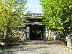 Tahara Castle
 -
 Nishinohama Wind Farm
 -
 Yoshigo Kaizuka


Notable people
- Watanabe Kazan, Edo period samurai and artist
- Noboru Ueda, motorcycle racer
- Kayoko Okubo, comedian
References
- ^ Tahara City official statistics (in Japanese)
- ^ "Tahara City Profile". Tahara Official Website. Retrieved November 11, 2011.
- ^ a b 気象庁 / 平年値(年・月ごとの値). JMA. Retrieved April 14, 2022.
- ^ 観測史上1~10位の値(年間を通じての値). JMA. Retrieved April 14, 2022.
- ^ Tahara population statistics
- ^ a b "International Exchange". List of Affiliation Partners within Prefectures. Council of Local Authorities for International Relations (CLAIR). Archived from the original on December 24, 2015. Retrieved November 21, 2015.
- ^ "Solar/Wind Electricity Generation Project in Tahara City". Toshiba Official Website. November 7, 2012. Retrieved November 7, 2012.
- ^ "News release details | News Release | MITSUI CHEMICALS, INC".
- ^ JERA official home page
- ^ "100 Soundscapes of Japan". Ministry of the Environment. Retrieved December 8, 2015.
External links
 Media related to Tahara, Aichi at Wikimedia Commons
 Tahara travel guide from Wikivoyage
 Geographic data related to Tahara, Aichi at OpenStreetMap
- Official website (in Japanese) (with link to English pages)
| Nagoya |
| |||
|---|---|---|---|---|
| Core cities | ||||
| Special city | ||||
| Cities | ||||
| Districts | ||||
| Former Districts | ||||
| International | |
|---|---|
| National | |
| Geographic | |
| Academics | |