
Tsushima, Aichi
Tsushima
津島市 | |
|---|---|
 Tsushima Tenno Festival | |
|
Japanese wisteria | |
| - Bird | Egret |
| Phone number | 0567-24-1111 |
| Address | 2-21 Tatekomi-chō, Tsushima-shi, Aichi-ken 496-8686 |
| Website | Official website |
Tsushima (津島市, Tsushima-shi) is a city located in Aichi Prefecture in the Chūbu region of Japan. As of October 1, 2019[update], the city had an estimated population of 61,647 in 26,559 households,[1] and a population density of 2,457 persons per km². The total area of the city is 25.09 square kilometres (9.69 sq mi).
Geography
Tsushima is located in far western Aichi Prefecture, on the alluvial plain of the Kiso Three Rivers.
Climate
The city has a climate characterized by hot and humid summers, and relatively mild winters (Köppen climate classification Cfa). The average annual temperature in Tsushima is 15.6 °C. The average annual rainfall is 1710 mm with September as the wettest month. The temperatures are highest on average in August, at around 27.9 °C with occasional typhoons , and lowest in January, at around 4.4 °C with occasional snow.[2] The East Asian rainy season occurs in June.
Demographics
Per Japanese census data,[3] the population of Tsushima has been relatively steady over the past 30 years.
| Year | Pop. | ±% |
|---|---|---|
| 1960 | 43,198 | — |
| 1970 | 51,441 | +19.1% |
| 1980 | 59,049 | +14.8% |
| 1990 | 59,343 | +0.5% |
| 2000 | 65,422 | +10.2% |
| 2010 | 65,237 | −0.3% |
Surrounding municipalities
- Aisai
- Kanie
- Ama
History
Middle Ages
Tsushima developed as a monzen-machi catering to the pilgrimage traffic to the well-known Shinto shrine of Tsushima Jinja from the Muromachi period.
Early modern period
During the
Late modern period
During the
Contemporary history
Tsushima was hit by the
Government
Tsushima has a
External relations
Twin towns – Sister cities
International
- Sister cities
- United States of America)
- since November 5, 1981
National
- Disaster Alliance city
 Kōnan (Aichi Prefecture, Chūbu region)
- since September 1, 2004
 Fujioka (Gunma Prefecture, Kantō region)
- since September 1, 2004
 Kasukabe (Saitama Prefecture, Kantō region)
- since September 1, 2004
Education
Schools
Tsushima has eight public elementary schools and four public junior high schools operated by the city government, and three public high schools operated by the Aichi Prefectural Board of Education. There are also one high school operated by the city government.
Transportation
Railways
Conventional lines
- Tsushima Line: - Tsushima – (Shobata) - (Fujinami) - Aotsuka -
- Bisai Line: - Tsushima -
Roads
Expressways
Japan National Route
Local attractions
- Tsushima Shrine
- The Japan Mosque of the Ahmadiyyas, largest mosque (by capacity) in Japan.
-
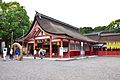 Tsushima Shrine
 -
 Tenno Matsuri
 -
 Wisteria Festival
 -
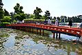 Tennōgawa Park
 -
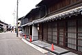 Temple town
 -
 Hottake House


Culture
Festival
- Tenno Matsuri, a festival with a history of over two hundred years. The highlight of this two-day event is the evening festival in which a dozen boats, each decorated with nearly 400 paper lanterns, float down the Tenno River.
Notable people from Tsushima
- Yone Noguchi (1875–1947), poet
- Mitsuharu Kaneko (1895–1975), poet
- Kiyoshi Takayama (b. 1947), yakuza tycoon
- Kanematsu Sugiura (1892-1979), cancer researcher
References
External links
- Official website (in Japanese)
| Nagoya |
| |||
|---|---|---|---|---|
| Core cities | ||||
| Special city | ||||
| Cities | ||||
| Districts | ||||
| Former Districts | ||||
| International | |
|---|---|
| National | |
| Geographic | |