
Moor Grange
| Moor Grange | |
|---|---|
West Yorkshire | |
| Ambulance | Yorkshire |
Leeds North West | |
Moor Grange Estate is a
For details on the original planning of the estate see the Leodis website.[1]
Education

On the junction of Spen Lane and Butcher Hill was West Park County Secondary (Girls) School. This building has now been demolished and a new housing estate is in the process of being built.
Abbey Grange School is located on Butcher Hill near to Hawksworth. Abbey Grange School was named after a former Kirkstall Abbey Mannor.[5] The School was opened on 11 October 1952 by the then Princess Royal Princess Mary, Countess of Harewood.[6]
For a picture of the now demolished Moor Grange County Secondary School see the Leodis Database [2]
Buildings
_005.jpg)
Moor Grange has three rows of shops which include newsagents, charity shop, and grocers. It does not have a church but close by on West Park is the West Park United Reformed Church. Another church was built in the late 1960s called St Andrews on the junction of Butcher Hill and Old Oak Drive which is technically on the Spen estate. Details on the St Andrews web site . The row of shops that has the Co-op is technically on the Spen Estate and used to contain a Milk delivery dairy and in the 70's a Fish and Chip Shop opened which was formerly a butcher shop.
Housing


There is a wide variety of council housing in Moor Grange built throughout the 1950s and 1960s. Most of the estate is made up of red brick
-
 Linton Croft Sheltered accommodation
 -
 Moor Grange Court
 -
 Semi-detached houses on Fillingfir Drive


Overview
Most Street names are preceded by Old Farm, Latchmere, Moor Grange and Fillingfir. It also benefits from three large grassed areas for recreation. Close by for fishing are Clayton Ponds which are located in Clayton Wood. Some old and recent pictures of the estate can be seen on the Leodis website which has a large collection of photos from Leeds and surrounding areas. It is circled by the West Park section of the Leeds Outer Ring Road (A6120), Spen Lane and Butcher Hill. There are three high rise blocks of flats: one on Butcher Hill called Moor Grange Court; the other two are Clayton Grange and Clayton Court at the bottom of Fillingfir Drive. At the corner of Old Farm Parade are three sets of maisonettes which have recently been renovated on the outside.[when?]
Proximity to the airport
Moor Grange is situated about 4 miles from
Odonyms
Old Farm Drive. Old Farm Close. Old Farm Garth. Old Farm Cross, Old Farm Walk. Old Farm Approach. Old Farm Parade. Latchmere Road, Latchmere Approach. Latchmere Green, Latchmere Cross. Latchmere View. Latchmere Drive. Latchmere Gardens. Latchmere Walk. Latchmere Crest. Latchmere Close. Fillingfir Drive. Fillingfir Road and Fillingfir Walk.
Moor Grange View, Moor Grange Rise, Moor Grange Drive and some of West Park Drive were built before the rest and probably around the same time as some of the houses on West Park. Technically they can be said to be part of the Moor Grange Estate.
Location
Transport
History
Moor Grange had a number of bus routes either passing through or terminating/starting on the estate. LCT bus route number 74 went from Moor Grange to
Current services
Bus services are now operated by
Pubs
Moor Grange has one pub called The Dalesman at the junction of Butcher Hill and Old Farm Approach. Its three rooms were once named
Trivia

Moor Grange was used as a backdrop for the TV series The Beiderbecke Affair which featured shots from Abbey Grange School, Butcher Hill playing fields and Clayton Grange Flats.[10]
Moor Grange is also used as one of the locations for the TV series Fat Friends. 'Midgleys' Fish and Chip Shop on Butcher Hill featured as 'Big and Battered Fish and Chip Shop'. on the series.[11]
Moor Grange is also the name of a row of houses in Yeadon situated on Victoria Road (A658).[12]
A bonfire used to be held every year on 5 November (Bonfire Night) on the field that is bordered by Old Farm Drive, although this has now been stopped due to health and safety restrictions.
Although Moor Grange was built on the site of an Old Farm there are more street names beginning with Latchmere than they are Old Farm and only three beginning with Moor Grange. Three roads also commence with the name Fillingfir and the 3 blocks of high rise flats are named .. Moor Grange Court, Clayton Grange and Clayton Court. Clayton maybe associated with nearby Clayton Ponds in Clayton Woods just across the ring road.
Moor Grange is also the name of a fictional Horse Stable and Country Estate set in Devon, UK in the books about "Kit Hunter Show Jumper" by Peter Grey. [13]
Moor Grange was also the name of a hall at the Leeds School of Medicine which in turn became the University of Leeds.
Moor Grange is also the name of a farm located on Scotland Lane, Horsforth, Leeds.
Gallery
Images of Moor Grange
-
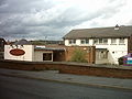
 Shops on Butcher Hill
 -
 The Dalesman public house on Butcher Hill
 -
 Public green on Old Farm Drive
 -
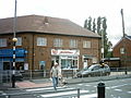 Shops on Butcher Hill/Spen Lane. Midgleys was used inYorkshire Television drama Fat Friends
 -
 Co-opon Butcher Hill/Spen Lane.
 -
 Shops on Butcher Hill/Spen Lane.
 -
 Butcher Hill
 -
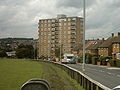 Moor Grange Court


References
- ^ "Leodis - a photographic archive of Leeds - Display". Archived from the original on 6 June 2011.
- ^ "Leodis - a photographic archive of Leeds - Display". Archived from the original on 6 June 2011.
- ^ "Leodis - a photographic archive of Leeds - Display". Archived from the original on 6 June 2011.
- ^ "Leodis - a photographic archive of Leeds - Display". Archived from the original on 6 June 2011.
- ^ "Leodis - a photographic archive of Leeds - Display". Archived from the original on 6 June 2011.
- ^ "Leodis - a photographic archive of Leeds - Display". Archived from the original on 6 June 2011.
- ^ "Aircraft over Moor Grange - 2007". YouTube.
- ^ "Archived copy" (PDF). www.wymetro.com. Archived from the original (PDF) on 17 November 2006. Retrieved 14 January 2022.
{{cite web}}: CS1 maint: archived copy as title (link) - ^ "First Bus | Bus Tickets, Timetables & Journey Planning" (PDF).
- user-generated source]
- ^ "Fat Friends (TV Series 2000–2005) - IMDb". IMDb.
- ^ "Google Maps".
- ^ "Kit Hunter Show Jumper".
External links
- Leodis.Org
- Horsforth.com
- Leeds City Council Web Site
- The ancient parish of Leeds: historical and genealogical information at GENUKI (The area now occupied by Moor Grange was in this parish).