
Mount Hayden (Arizona)
| Mount Hayden | |
|---|---|
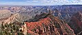
 Northwest aspect seen from Point Imperial | |
| Highest point | |
| Elevation | 8,362 ft (2,549 m)[1] |
| Prominence | 522 ft (159 m)[1] |
| Isolation | 2.44 mi (3.93 km)[2] |
| Coordinates | 36°16′21″N 111°58′09″W / 36.2725811°N 111.9691092°W[3] |
| Naming | |
| Etymology | Charles T. Hayden |
| Geography | |
 Mount Hayden  Mount Hayden | |
| Location | |
Mount Hayden is an 8,362-foot (2,549 m)-elevation summit located in the
Cold semi-arid climate zone.[5]
Geology
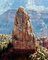
The summit spire of Mount Hayden is composed of cream-colored, cliff-forming, Permian Coconino Sandstone caprock.[6] This sandstone, which is the third-youngest of the strata in the Grand Canyon, was deposited 265 million years ago as sand dunes. Below this Coconino Sandstone is reddish, slope-forming, Permian Hermit Formation, which in turn overlays the Pennsylvanian-Permian Supai Group. Precipitation runoff from this feature drains east into the Colorado River via Nankoweap Creek.
Gallery
-
-
-

-
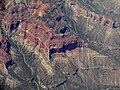
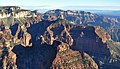 Aerial view looking northeast at Mt. Hayden
 -
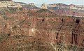 Aerial view of Mt. Hayden centered
 -
 Mt. Hayden from an airplane
 -
 Mt. Hayden (lower left) by Ansel Adams ca. 1942
.jpg)
.jpg)


See also
References
- ^ a b c "Mount Hayden, Arizona". Peakbagger.com. Retrieved 2020-12-16.
- ^ a b "Mount Hayden – 8,362' AZ". Lists of John. Retrieved December 16, 2020.
- ^ a b c d "Mount Hayden". Geographic Names Information System. United States Geological Survey, United States Department of the Interior. Retrieved 2020-12-16.
- ISBN 978-1934656006, page 198.
- ISSN 1027-5606.
- ISBN 9781934656013, page 54.
External links
Wikimedia Commons has media related to Mount Hayden.
- Weather forecast: National Weather Service
- Mount Hayden rock climbing: Mountainproject.com