
Mount Larrabee
| Mount Larrabee | |
|---|---|
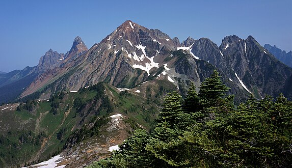
 Mount Larrabee and the Border Peaks seen from Winchester Mountain Lookout | |
| Highest point | |
| Elevation | 7,865 ft (2,397 m) NAVD 88[1] |
| Prominence | 981 ft (299 m)[1] |
| Parent peak | American Border Peak (7,994 ft) |
| Isolation | 1.34 mi (2.16 km)[1] |
| Coordinates | 48°58′45″N 121°38′53″W / 48.9791022°N 121.6481266°W[2] |
| Geography | |
 Mount Larrabee Location in Washington  Mount Larrabee Mount Larrabee (the United States) | |
| Country | United States |
| State | class 3 scramble |
Mount Larrabee is a 7,865-foot (2,397-metre)
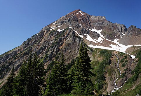
Mount Larrabee can be seen from the Mt. Baker Highway near Heather Meadows and Artist Point, as well as from points in the Fraser Valley in Canada. On Larrabee's east ridge are a series of jagged spires called The Pleiades. Larrabee's northwest ridge connects to American Border Peak. Precipitation runoff on the west side of the mountain drains into Tomyhoi Lake and Tomyhoi Creek, whereas the east side of the mountain drains to Silesia Creek, and both creeks flow north to the Chilliwack River in Canada. An unnamed glacier known colloquially as Larrabee Glacier lies below the steep north face. Downslope of that glacier is the Boundary Red Mountain Mine where gold was discovered in the early 1900s. The Gargett Mine was located on the southwest slope north of High Pass, but it didn't produce quality ore and was abandoned.
The summit offers views of Tomyhoi Peak, American Border Peak, Slesse Mountain, Mount Challenger, the Picket Range, Mount Shuksan, and Mount Baker. Normal access is via the Twin Lakes Road and High Pass Trail. The Winchester Mountain Lookout provides a nice vantage to photograph Larrabee, and shelter to sleep under a roof.
Climate
Mount Larrabee is located in the

Weather fronts originating in the Pacific Ocean travel northeast toward the Cascade Mountains. As fronts approach the North Cascades, they are forced upward by the peaks of the Cascade Range (orographic lift), causing them to drop their moisture in the form of rain or snowfall onto the Cascades. As a result, the west side of the North Cascades experiences high precipitation, especially during the winter months in the form of snowfall.[3] Because of maritime influence, snow tends to be wet and heavy, resulting in high avalanche danger.[3] Due to its temperate climate and proximity to the Pacific Ocean, areas west of the Cascade Crest very rarely experience temperatures below 0 °F (−18 °C) or above 80 °F (27 °C).[3] During winter months, weather is usually cloudy, but, due to high pressure systems over the Pacific Ocean that intensify during summer months, there is often little or no cloud cover during the summer.[3]
Geology

The North Cascades features some of the most rugged topography in the
The history of the formation of the Cascade Mountains dates back millions of years ago to the late
During the Pleistocene period dating back over two million years ago, glaciation advancing and retreating repeatedly scoured the landscape leaving deposits of rock debris.[4] The U-shaped cross section of the river valleys is a result of recent glaciation. Uplift and faulting in combination with glaciation have been the dominant processes which have created the tall peaks and deep valleys of the North Cascades area.
See also
Gallery
-
 from Winchester Mountain
 -
 from High Pass
 -
 Winter sunrise


References
- ^ a b c "Mount Larrabee, Washington". Peakbagger.com. Retrieved 2017-04-23.
- ^ a b c "Mount Larrabee". Geographic Names Information System. United States Geological Survey, United States Department of the Interior. Retrieved 2020-04-18.
- ^ ISBN 978-1-59485-136-0.
- ^ a b c d Kruckeberg, Arthur (1991). The Natural History of Puget Sound Country. University of Washington Press.
External links
- Mt. Baker Wilderness U.S. Forest Service
- Mt. Larrabee weather: Mountain Forecast
- Climbing Larrabee: YouTube
Places adjacent to Mount Larrabee | |
|---|---|