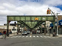
Myrtle Avenue
Forest Park | |
| East end | Jamaica Avenue in Richmond Hill |
|---|---|

Myrtle Avenue is a 8.1-mile-long (13.0 km) street that runs from Duffield Street in
.Route description
Brooklyn
In the neighborhoods of Fort Greene and Clinton Hill, the development of Myrtle Avenue was directly related to the Brooklyn Navy Yard, built in 1801. In 1847 Fort Greene Park, Brooklyn's first park, was built on the south side of western Myrtle Avenue. It was a busy thoroughfare since early on in its existence. During World War II, the Navy Yard employed more than 71,000 people, many of them African American shipbuilders. As a result, the demand for housing in the area increased, prompting the New York City Housing Authority to build the Walt Whitman and Raymond Ingersoll public housing on Myrtle Avenue in 1944.
In the 1970s, the decommissioning of Brooklyn Navy Yard and demolition of much of the Myrtle Avenue Elevated train line, along with an influx of poorer residents into the Bedford-Stuyvesant and Bushwick neighborhoods, led to a decline in the vitality of the avenue, with business closures and increased crime. At its nadir of decline, the street became jokingly known to many Brooklynites as "Murder Avenue".[2]
In the 1990s the western end of Myrtle Avenue was closed from Jay Street to Flatbush Avenue Extension to create the
In the 21st century the economic revitalization of Brooklyn and
Queens
Myrtle Avenue has been a major thoroughfare since the early 19th century, named after the myrtle trees that were plentiful in the area. Most likely, Myrtle Avenue began in Queens and was a plank road that charged a toll. The road eventually hosted the Knickerbocker Stage Coach Line, that ran stagecoach and omnibus services. After World War I, Myrtle Avenue in Glendale was a popular destination for picnickers. With a steam trolley running on the avenue, and its ample adjacent beer gardens and park space, people from as far as Eastern Brooklyn came to Myrtle. In the mid-1920s, the parks closed as a result of Prohibition. Ultimately, the parks became incorporated by the city into what is known today as Forest Park.[3]
Currently, Myrtle Avenue is one of the primary shopping strips of Ridgewood, along with Fresh Pond Road whose south end is at Myrtle Avenue. It is also the primary shopping strip in nearby Glendale, although this stretch of Myrtle Avenue is not as busy as the Ridgewood stretch. It was also home to the Ridgewood Theatre, which was the longest continuously operated theater in the United States, having operated for 91 years before its closure in March 2008.[4]
Myrtle Avenue is the starting point for several major thoroughfares in Queens that were built later. This includes
Transportation
The
Myrtle Avenue is currently served by the following subway stations, west to east:
- Myrtle–Willoughby Avenues (Gtrain)
- Z trains)
- Central Avenue (Mtrain)
- Knickerbocker Avenue (Mtrain)
- Myrtle–Wyckoff Avenues; a station complex consisting of:
Also,
Two bus routes primarily serve the avenue. The Queens stretch of Myrtle Avenue is served by the
In popular culture
There are references to Myrtle Avenue in
Other artists that mention Myrtle Avenue include:
- Nas refers to Willoughby and Myrtle Ave in the song "Virgo" with Ludacris and Doug E. Fresh.
- Prodigy from Mobb Deep references Myrtle in "Trife Life" on The Infamous album.
- Mos Def says he's from Myrtle and Broadway in the song "Champion Requiem" on The New Danger, and in the song "Mathematics" on Black on Both Sides.
- Talib Kweli references the street in the Black Eyed Peas' song "Like That" - "Like a caribou running down myrtle avenue".
- Digable Planets reference the avenue in the song "9th Wonder (Blackitolism)" when Butterfly rhymes - "Myrtle Ave A Train got the pick in my hair".
- Prince Paul references Myrtle Avenue in his song "People, Places & Things".
- Lord Jamar refers to Myrtle Avenue in the Brand Nubian song "Straight Off Tha Head"
- Henry Miller in Tropic of Capricorn wrote about the horrible conditions of Myrtle Avenue.
- Tory Lanez references Myrtle Avenue as the birthplace of a character in his song "Pieces" from his album Memories Don't Die.
References
- ^ a b Google (January 14, 2017). "Myrtle Avenue" (Map). Google Maps. Google. Retrieved January 14, 2017.
- ^ Deborah Kolben (March 27, 2004). "Myrtle Avenue the new hot strip". The Brooklyn Papers.
- ^ a b "History of Myrtle Avenue". Myrtle Avenue Brooklyn Partnership. Archived from the original on October 26, 2005. Retrieved August 31, 2006.
- ^ Austin Considine (March 27, 2008). "Ridgewood Theatre Closes Its Curtain After 91 Years". Queens Chronicle. Archived from the original on 2009-02-14. Retrieved 2008-07-25.
- ^ Joseph Brennan (2002). "Abandoned Stations:Myrtle Ave".
- ^ Courtney Reimer (July 18, 2005). "As "Adult-Oriented Store" Moves In, Neighbors Worried Crime May Follow". The New York Times.
External links
- Brooklyn Bites: Neighborhood Dining Guide for Myrtle Avenue in GO Brooklyn
- Robert Gerhard. Myrtle avenue. Street Shooters of May 2018
